Tornado Risk Upgraded in Southwest Oklahoma and Texas Panhandle as Storm Prediction Center Warns of Possible Significant Twisters
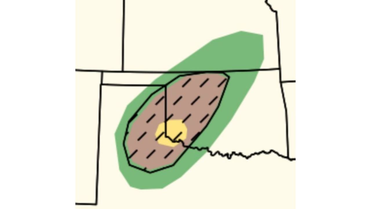
UNITED STATES — Forecasters with the Storm Prediction Center (SPC) have upgraded the tornado threat across parts of the southern Plains, highlighting extreme southwest Oklahoma and the southeast Texas Panhandle as areas that could experience dangerous severe storms capable of producing isolated significant tornadoes later today.
Meteorologists say the upgraded risk reflects increasing concern that storms forming along a developing weather boundary may become surface-based, allowing them to strengthen rapidly during the afternoon and evening hours.
Highest Tornado Risk Focused Near Oklahoma–Texas Border
Weather outlook maps show the core tornado threat centered near the Oklahoma–Texas border, particularly across:
- Southwest Oklahoma
- The southeastern Texas Panhandle
- Areas close to the western Oklahoma region
Within this corridor, atmospheric conditions may support strong rotating thunderstorms capable of producing tornadoes.
A smaller highlighted zone within the broader risk area suggests the potential for a more concentrated tornado threat, depending on where storms form relative to the boundary.
Storm Development Depends on Boundary Location
Meteorologists say the key factor determining storm strength will be the exact placement of a frontal boundary across the region.
Storms that develop along or south of this boundary could tap into warmer, unstable air near the surface. When thunderstorms become surface-based in this environment, they can more easily organize into supercells, the type of storm most often associated with significant tornadoes.
If storms remain elevated north of the boundary, the tornado threat would likely remain lower.
Significant Tornado Potential Exists
Forecasters caution that if the atmospheric setup aligns correctly, isolated significant tornadoes could develop, meaning storms capable of producing stronger tornadoes rather than brief weak spin-ups.
Such storms can form quickly and may intensify rapidly if wind shear and instability combine in the right way.
Because of this possibility, meteorologists are urging residents across the highlighted areas to remain alert throughout the day.
Residents Urged to Stay Weather Aware
Officials stress the importance of having multiple ways to receive weather warnings, especially as storms may develop quickly and intensify during the afternoon and evening hours.
Residents in southwest Oklahoma and the southeast Texas Panhandle are encouraged to monitor forecasts, keep weather alerts enabled on mobile devices, and be prepared to take shelter if warnings are issued.
Additional forecast updates are expected as meteorologists gain more clarity on storm development and the exact placement of the boundary driving the severe weather risk.
For continuing coverage of severe weather threats and major storm developments across the United States, follow updates from ChicagoMusicGuide.com.