Northern Oklahoma Sees Rare Dominant Supercell as Boundary Surges North, Creating Unexpected Tornado-Producing Storm
NORTHERN OKLAHOMA — Meteorologists are tracking a powerful dominant supercell across northern Oklahoma, a storm that developed after a key atmospheric boundary shifted significantly farther north than forecast models had predicted.
The unexpected boundary movement created a favorable environment for severe thunderstorms, allowing a single storm to become highly organized and repeatedly cycle, a behavior commonly associated with tornado-producing supercells.
Forecasters say the development highlights how rapidly severe weather setups can change when real-time atmospheric conditions differ from model projections.
Boundary Shift Created Ideal Conditions for Supercells
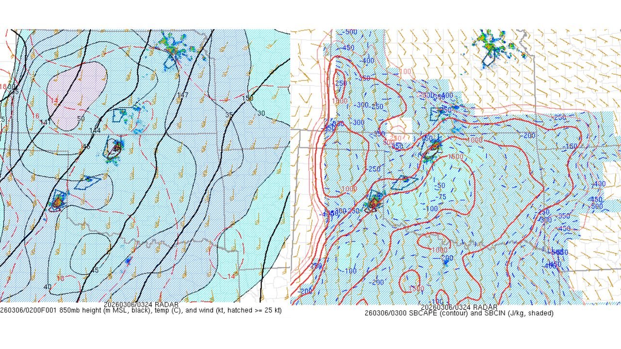
According to meteorological analysis, the main reason for the storm’s rapid intensification is that a frontal or outflow boundary lifted farther north than anticipated, placing northern Oklahoma directly within a zone of stronger wind shear and atmospheric instability.
Supercells often form along boundaries where temperature, moisture, and wind patterns sharply contrast, creating the rotation necessary for severe thunderstorms.
Because the storm formed along this boundary, it has been able to sustain itself and cycle multiple times, meaning it can repeatedly strengthen as new rotating updrafts develop.
Models Failed to Capture Boundary Movement
Forecast models earlier in the day did not indicate the boundary would move this far north, which allowed the environment across northern Oklahoma to become more favorable for severe weather than initially expected.
This kind of situation can lead to surprise severe storms, particularly when real-time observations reveal features that were not captured in model guidance.
Meteorologists often emphasize that boundaries such as these are one of the most important ingredients in severe weather forecasting, because storms interacting with them can intensify quickly.
Strong Wind Shear Helping Storm Maintain Strength
Atmospheric data from the region shows strong wind shear across multiple levels of the atmosphere, another key factor that allows supercell thunderstorms to organize and maintain rotation.
Wind shear refers to changes in wind speed and direction with height, which helps thunderstorms develop a tilted rotating updraft known as a mesocyclone.
This rotation allows the storm to persist for longer periods compared to typical thunderstorms.
Potential for Tornado Development
When a supercell forms along a boundary with strong wind shear, the risk of tornado development increases, particularly if the storm continues to cycle and strengthen.
Meteorologists monitoring the situation say the storm’s behavior is consistent with dominant supercell characteristics, meaning it could continue producing severe weather as it tracks across the region.
Forecasters Continue Monitoring Storm Evolution
Weather experts are continuing to analyze radar and atmospheric data as the storm evolves, watching for signs of further intensification or additional supercell development along the boundary.
Situations like this illustrate how severe weather can become more dangerous when atmospheric boundaries shift unexpectedly, creating conditions that favor strong rotating storms.
Residents across northern Oklahoma and nearby areas are encouraged to remain weather aware and monitor warnings as storms move through the region.
For continuing coverage of major weather developments across the United States, follow updates from ChicagoMusicGuide.com.