Backdoor Cold Front Disrupts East Coast Warmup as Temperatures Across Maryland, D.C., and Virginia Split by Nearly 30 Degrees
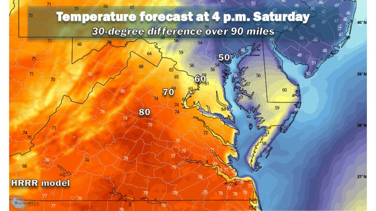
WASHINGTON, D.C. — A surprising backdoor cold front has disrupted what was expected to be a much warmer stretch across the Mid-Atlantic region, leaving temperatures far cooler than forecast across parts of Maryland, Washington D.C., and northern Virginia. Meteorologists say the unexpected front has created a dramatic temperature contrast across the region, with some areas struggling to reach 50 degrees while locations only 90 miles away could approach 80 degrees.
Just a week ago, many weather models projected high temperatures near 70 degrees, with some forecasts even suggesting readings above 70 for the weekend. Instead, temperatures on Friday failed to reach 60 degrees in several locations, and many areas may struggle to climb much higher on Saturday as cooler air continues to filter into the region.
Backdoor Cold Front Brings Cool Atlantic Air Into the Mid-Atlantic
Meteorologists say the sudden change is the result of a weak backdoor cold front that slipped south from the north and stalled near the Mid-Atlantic coastline. Unlike typical cold fronts that move from west to east, a backdoor front pushes cooler air southwestward from the Atlantic Ocean toward inland areas.
In this case, winds north of the boundary have shifted to the northeast, drawing in cool marine air from the Atlantic Ocean and Chesapeake Bay. This process allows cooler air to spread inland, dramatically reducing temperatures across parts of Maryland, Washington D.C., and nearby coastal regions.
These types of springtime weather boundaries are known for disrupting warming trends and surprising forecasters, particularly when cooler marine air spreads farther inland than initially expected.
Temperature Differences Could Reach 30 Degrees Across Short Distance
Weather model projections show that temperatures Saturday afternoon could vary dramatically across the Mid-Atlantic region. Forecast graphics indicate temperatures may reach near 80 degrees in parts of central and southern Virginia, while communities closer to the Chesapeake Bay and northern Maryland may remain stuck in the 50s or low 60s.
This sharp gradient means that temperatures could differ by nearly 30 degrees across just 90 miles, creating one of the most noticeable temperature contrasts of the early spring season.
Cities southwest of the Capital Beltway, including areas deeper into Virginia, are expected to have the best chance of approaching 70 degrees or higher during the weekend. Meanwhile, areas northeast of Washington D.C., including parts of Maryland and the Chesapeake Bay region, may continue experiencing cooler conditions.
Warmer Temperatures Expected to Return Early Next Week
Despite the chilly interruption, meteorologists say the cooler air mass is expected to weaken by the start of next week. Forecast confidence is increasing that the cool wedge of marine air will break down by Monday, allowing warmer air to return to much of the Mid-Atlantic region.
Temperatures are expected to gradually climb back into the 70s by Monday through Wednesday, with some areas potentially approaching 80 degrees by midweek if warmer air fully pushes northward.
For now, forecasters say the unusual spring weather pattern highlights how quickly conditions can change across the Mid-Atlantic, especially when coastal weather boundaries influence inland temperatures.
As meteorologists continue tracking evolving weather patterns across the United States, readers can find ongoing updates on regional forecasts and developing weather trends at ChicagoMusicGuide.com.