Supercell Threat Targets Oklahoma, Arkansas, Kansas, and Missouri as Evening Storms Could Produce Isolated EF2+ Tornado
UNITED STATES — Meteorologists are monitoring a developing severe weather setup across the central United States, where atmospheric conditions may support rotating supercells capable of producing damaging winds, large hail, and even isolated tornadoes later today and tonight.
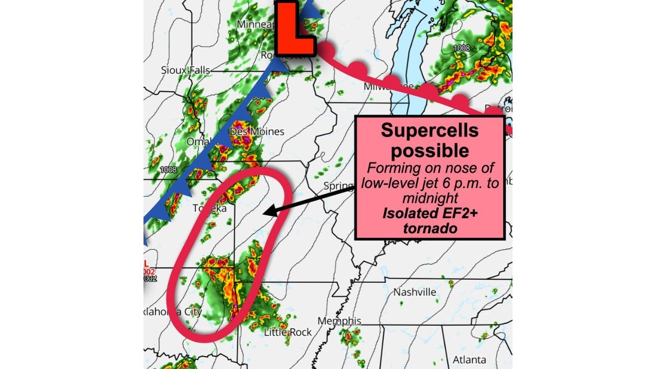
Forecast analysis shows the greatest risk zone stretching across northeast Oklahoma, northwest Arkansas, eastern Kansas, and western Missouri, where the environment may become favorable for organized severe storms as the evening progresses.
Forecasters say the timing of increasing wind energy in the atmosphere could play a crucial role in storm development.
Low-Level Jet Expected to Strengthen Storm Rotation
One of the most important ingredients in this setup is the strengthening low-level jet stream, which is expected to intensify around sunset and continue through midnight. This fast-moving ribbon of wind just above the ground can enhance wind shear, meaning winds change direction and speed with height.
That combination of instability and increasing wind shear can allow thunderstorms to organize into supercells — rotating storms capable of producing tornadoes.
Weather analysts note that the nose of the low-level jet, where the strongest wind energy feeds into storms, may overlap with developing thunderstorms across parts of Oklahoma and Kansas, creating the most favorable conditions for rotating storms.
Areas Near Oklahoma City and Eastern Kansas Could See Initial Storm Development
Radar model projections show storms developing along a cold front pushing southeastward through Kansas toward Oklahoma. As storms form and intensify, they are expected to move toward parts of northeast Oklahoma and northwest Arkansas during the evening hours.
Communities near Oklahoma City, Topeka, and surrounding areas in eastern Kansas may see the first round of storms forming along the advancing front. As the system evolves, storms could continue tracking east or southeast toward western Missouri and northwest Arkansas.
Meteorologists say clusters of strong thunderstorms could develop into rotating supercells, particularly where storms interact with favorable wind patterns.
Tornado Potential Includes Chance for Isolated Strong Tornado
While not every storm will produce a tornado, the overall atmospheric setup suggests that a few storms could become strong enough to generate tornadoes, especially in the most unstable pockets of the region.
Forecast guidance indicates the possibility of isolated EF2-strength tornadoes, though these would likely be limited to areas where storm rotation becomes strongest.
The greatest window for severe storms appears to be between 6 p.m. and midnight, when the low-level jet strengthens and storms are most likely to organize.
Damaging Winds and Hail Also Possible
Even outside of tornado development, severe thunderstorms in this pattern could still produce dangerous straight-line winds, heavy rainfall, and large hail.
Storm clusters forming along the front may also evolve into lines of strong thunderstorms capable of producing widespread gusty winds, particularly if storms merge later in the evening.
Meteorologists say residents across Oklahoma, Arkansas, Kansas, and Missouri should remain alert for rapidly changing weather conditions as the storm system develops tonight.
Monitoring Storm Evolution Across the Plains
Forecasters will continue analyzing radar trends and updated model guidance throughout the day as storms begin forming along the advancing front. The exact placement of the strongest storms and tornado risk will depend on where instability and wind shear overlap during the evening hours.
Residents in the affected states are encouraged to monitor local alerts and ensure they have a reliable way to receive warnings overnight, when severe weather can sometimes strike with little notice.
Stay with ChicagoMusicGuide.com for the latest severe weather updates and analysis as this developing Plains storm system continues to evolve.