Illinois Severe Storm Threat Tuesday as Tornado Risk Develops South of I-80 and Very Large Hail Threat Targets Northern Illinois
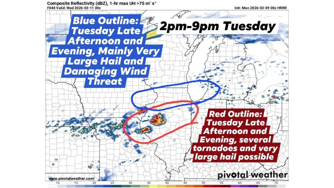
CHICAGO, ILLINOIS — Updated high-resolution forecast models are continuing to highlight a volatile severe weather setup across Illinois on Tuesday, with storms expected to develop during the late afternoon and evening hours between roughly 2 PM and 9 PM. Forecast guidance shows a stalling warm front near the Interstate 80 corridor, which may become the key dividing line between two different severe weather threats across the state.
South of the boundary, conditions may support multiple tornado-producing storms, while areas farther north could experience very large hail and damaging winds as the primary hazards.
Warm Front Near I-80 Could Define Illinois Severe Weather Zones
Forecast data consistently shows the warm front stalling near the I-80 corridor across northern Illinois, which is expected to act as the cutoff for the most intense tornado potential.
Areas along and south of the warm front could enter the most unstable portion of the storm environment during the late afternoon and evening. In this region, thunderstorms may strengthen into rotating supercells capable of producing several tornadoes, some of which could become strong if storms remain organized.
Cities potentially impacted within this southern corridor include Peoria, Bloomington, Champaign, and areas south of the Chicago metro region, where the environment may favor more intense storm development.
Very Large Hail and Damaging Winds Expected Across Northern Illinois
Farther north of the warm front, the severe weather setup appears different. While tornado potential decreases in this zone, the environment may still support powerful thunderstorms capable of producing very large hail and strong winds.
Forecast guidance suggests hail sizes could range from quarter size up to baseball size in the strongest storms, especially across northern Illinois including the Chicago metropolitan area, Rockford, and surrounding communities.
Storms developing north of the boundary may move rapidly through the region during the evening hours, bringing bursts of intense lightning, heavy rainfall, and damaging wind gusts.
Storm Development Expected Tuesday Afternoon and Evening
Weather models indicate that thunderstorms could begin developing late Tuesday afternoon across central Illinois, before spreading northeastward during the evening.
The most active time period for severe weather appears likely between 2 PM and 9 PM, when atmospheric instability and wind patterns align across the region.
Clusters of storms may form across central Illinois and track toward northern Illinois and the southern Great Lakes, potentially impacting major population centers including Chicago and nearby suburbs.
Forecast Details May Still Shift Before Storms Arrive
Although model trends continue to point toward a significant severe weather setup across Illinois, the exact position of the warm front will play a critical role in determining where the greatest tornado risk ultimately develops.
Even a small shift north or south in this boundary could move the highest tornado potential closer to the Chicago area or farther south into central Illinois.
Residents across Illinois, especially near and south of the I-80 corridor, are encouraged to monitor updated forecasts and remain alert for possible severe thunderstorm watches or tornado watches Tuesday afternoon and evening.
As the forecast continues to evolve, ChicagoMusicGuide.com will provide updated information on storm timing, tornado potential, and severe weather alerts affecting Chicago, northern Illinois, and surrounding Midwest communities.