Tennessee and Kentucky Severe Weather Risk Wednesday Night as Storm Prediction Center Issues Slight Risk for Damaging Winds and Possible Tornadoes
TENNESSEE, UNITED STATES — Forecast models have remained consistent over the past several days in signaling a potentially active severe weather setup Wednesday evening and overnight across parts of Tennessee and Kentucky. Meteorological guidance shows a moist and unstable air mass moving into the region ahead of an approaching storm system, creating conditions that could support organized severe thunderstorms later in the day.
The developing weather pattern is expected to include a strong low-level jet and an advancing cold front, which together may trigger a line of storms capable of producing damaging winds and isolated tornadoes as the system pushes eastward across the region.
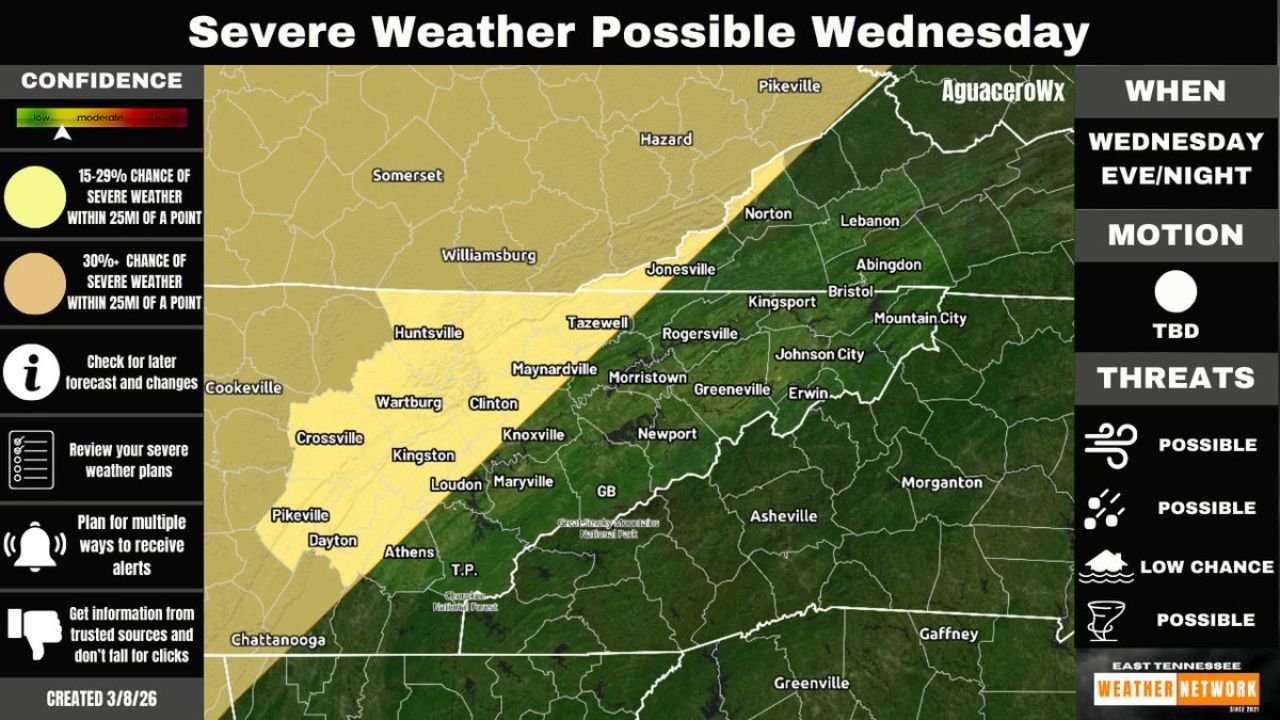
Slight Risk Issued for Parts of Tennessee and Kentucky
The Storm Prediction Center has already placed portions of eastern Tennessee and southeastern Kentucky under a Slight Risk for severe weather, which corresponds to Level 2 out of 5 on the national severe weather scale. While this level does not indicate an extreme outbreak, it does highlight a real and measurable threat of severe storms developing Wednesday evening and continuing overnight.
Areas included in the highlighted zone include Knoxville, Morristown, Crossville, Dayton, and parts of southeastern Kentucky near Somerset and Williamsburg. Communities across this region may see storms strengthening as they approach during the evening hours.
Meteorologists note that the exact timing and storm coverage remain uncertain, as forecast models still show some differences in how quickly the storm system organizes and moves through the region.
Damaging Winds Could Be the Primary Hazard
Weather setups involving a strong cold front and organized storm lines often produce damaging straight-line winds, which could become the primary severe weather hazard Wednesday night.
Storms may form into a squall line along the advancing front, allowing powerful wind gusts to spread across parts of Tennessee and Kentucky during the overnight hours. These winds can sometimes cause damage similar to weaker tornadoes, including downed trees, power outages, and structural damage.
While damaging winds appear to be the most likely threat at this stage, the atmospheric pattern could still allow isolated tornadoes to develop within the storm line, particularly if storms become more organized than currently expected.
Forecast Confidence Still Evolving Before Wednesday Evening
Meteorologists emphasize that forecast confidence will continue improving as new model data becomes available over the next 24 to 36 hours. Small shifts in the timing of the cold front or the strength of the low-level jet could change the intensity or coverage of severe storms.
Residents across eastern Tennessee and southeastern Kentucky are encouraged to review their severe weather safety plans and ensure they have multiple ways to receive weather alerts, especially if outdoor activities are planned for Wednesday evening.
Storm details, including the exact arrival time and potential storm strength, should become clearer as the weather system moves closer to the region.
For continued updates on severe weather developments across the United States and regional forecast coverage, readers can follow the latest reports and weather analysis on ChicagoMusicGuide.com.