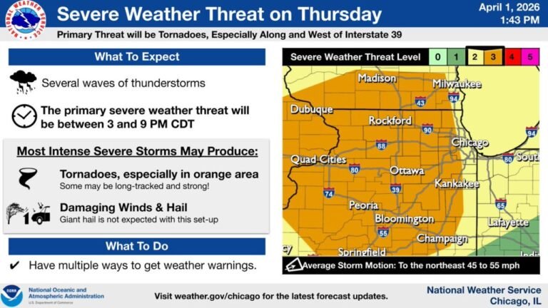
Illinois and Texas in Dual Hail Crosshairs Tuesday as Egg-Sized Stones Target Midwest and Tennis-Ball Hail Threatens Southern Plains
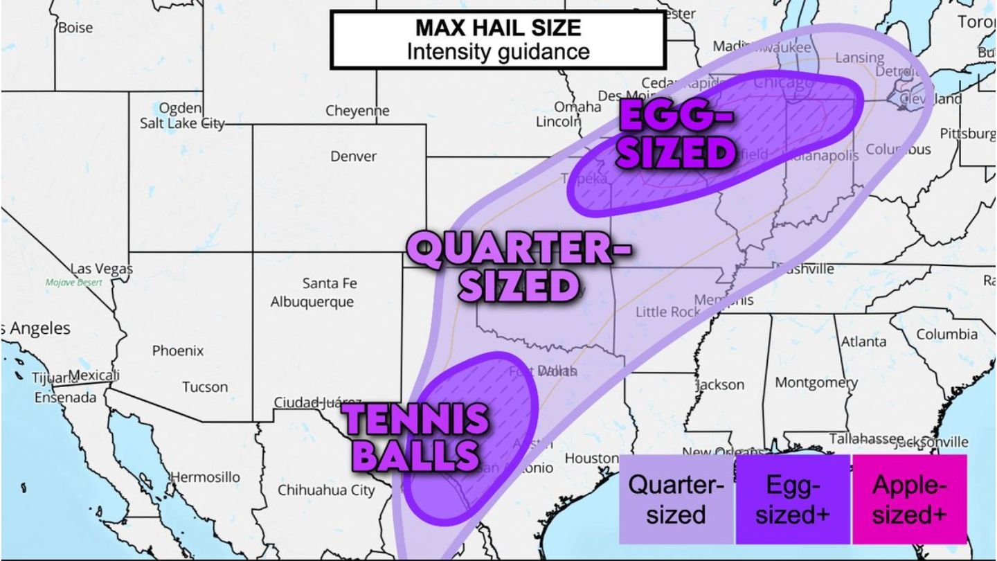
ILLINOIS — Severe weather concerns Tuesday are not limited to tornadoes. Updated hail intensity guidance shows two distinct hail corridors developing — one stretching across the Corn Belt and Midwest, including Illinois, and another across Texas and the Southern Plains. Forecast models indicate hail could reach egg-sized across parts of Illinois and neighboring Midwest states, while tennis-ball-sized hail may fall in sections of Texas.
The setup points to widespread strong updrafts capable of producing large and damaging hail during the afternoon and evening hours.
Egg-Sized Hail Targeting Illinois and the Midwest
The northern hail corridor extends from portions of Missouri and Iowa through Illinois, Indiana, and into parts of Michigan and Ohio. Within this zone, guidance suggests hail stones could grow to egg-sized or larger, particularly where supercells become established.
Cities in or near this projected corridor include:
- Chicago
- Rockford
- Peoria
- Indianapolis
- Detroit
The presence of strong instability and wind shear across the Midwest will allow storms to develop powerful rotating updrafts. These updrafts can suspend hailstones long enough for them to grow to significant sizes before falling.
Even areas outside the peak tornado risk could experience destructive hail capable of damaging vehicles, roofs, and crops.
Quarter-Sized to Large Hail Through the Central Corridor
A broader swath of the central United States — from Oklahoma and Arkansas through Missouri and Illinois — remains under a zone supportive of quarter-sized hail or larger. This region overlaps with ongoing severe weather concerns and could experience multiple rounds of storms.
While not every storm will produce significant hail, any sustained supercell within this instability axis has the potential to generate damaging hail events.
Residents across the Midwest and central Plains should be prepared for rapid storm intensification and sudden severe hail bursts.
Tennis-Ball Hail Threat Across Texas
The southern hail maximum appears across parts of central and eastern Texas, where guidance highlights the potential for tennis-ball-sized hail in stronger supercells.
Cities near the core of this threat include:
- Austin
- San Antonio
- Fort Worth
- Surrounding areas of central Texas
The southern Plains environment features strong instability and sufficient shear for robust rotating storms. While tornadoes remain possible in parts of Texas, hail may be the most widespread severe hazard in this zone.
Tennis-ball-sized hail can cause extensive structural damage and significant vehicle destruction within minutes.
Two Severe Zones, One High-Impact Evening
The presence of two separate hail corridors underscores the widespread nature of Tuesday’s severe weather pattern. From Texas through the Corn Belt and into the Great Lakes, atmospheric conditions favor intense thunderstorm development.
Across Illinois and surrounding Midwest states, egg-sized hail appears increasingly likely in stronger storms. Meanwhile, Texas faces the potential for even larger hailstones, especially in isolated supercells.
Timing for both regions centers on the late afternoon through late evening hours, when instability peaks and storms mature.
Preparation Essential Ahead of Storm Development
Large hail often strikes with little warning and can cause significant damage in a short period of time. Residents in both the Midwest and Texas should consider:
- Parking vehicles in covered areas
- Securing outdoor items
- Monitoring severe thunderstorm warnings closely
With dual severe zones developing Tuesday, the threat of damaging hail spans hundreds of miles.
For continued updates on Illinois hail risk, Texas severe storms, and Midwest weather developments, visit ChicagoMusicGuide.com for the latest forecast analysis and storm tracking.