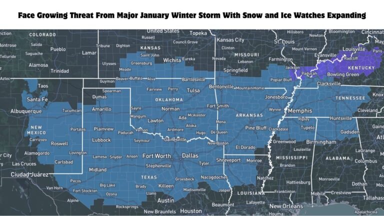
Deep Northwest Storm Cycle Slams Washington, Oregon, British Columbia, Idaho and Montana with Multi-Foot Snow Through March 14
SEATTLE, WASHINGTON — A powerful and persistent storm cycle is hammering the Northwestern United States and southwestern Canada, with heavy mountain snowfall continuing through Saturday, March 14, delivering multi-foot totals across key ranges in Washington, Oregon, Idaho, Montana, and British Columbia.
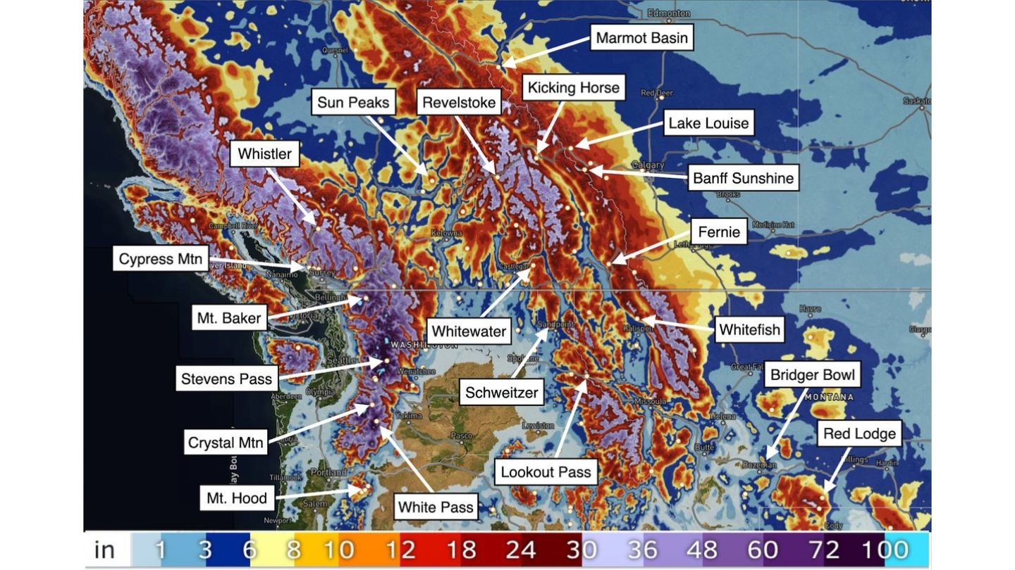
Forecast projections for March 8–13 show widespread double-digit snowfall totals, with some high-elevation resorts expected to measure two to four feet — and isolated locations pushing beyond that.
Washington and Oregon: Cascades Under Siege
The Washington Cascades are firmly in the crosshairs.
Resorts and passes including:
- Mt. Baker
- Stevens Pass
- Crystal Mountain
- White Pass
- Mt. Hood (Oregon)
are forecast to receive significant accumulations. Color-scale projections indicate widespread 12–24 inches, with pockets exceeding 30 inches in favored terrain.
Mt. Baker, historically one of the snowiest places in North America, stands out again with deep totals likely as moist Pacific flow slams into the Cascades.
British Columbia: Whistler to Revelstoke Buried
North of the border, snowfall intensifies along the Coast and Columbia Mountains.
Major ski destinations including:
- Whistler
- Sun Peaks
- Revelstoke
- Kicking Horse
- Marmot Basin
- Lake Louise
- Banff Sunshine
- Fernie
are positioned beneath heavy precipitation bands.
The snowfall gradient shows widespread 18–36 inches, with localized totals possibly exceeding 40 inches in higher elevations around Revelstoke and Kicking Horse — areas known for deep snowpacks during prolonged Pacific storm tracks.
Idaho and Western Montana: Snow Spreads Inland
As the storm energy pushes east, interior mountain zones also see major impacts.
Locations highlighted include:
- Whitewater
- Schweitzer
- Lookout Pass
- Whitefish
- Bridger Bowl
- Red Lodge
These areas show projected accumulations of 12–24 inches, with isolated higher terrain pushing toward 30 inches or more.
Western Montana, particularly around Whitefish and Bridger Bowl, appears primed for strong orographic enhancement as moist flow lifts over the Continental Divide.
Multi-Day Storm Pattern Through March 14
The key factor in this event is persistence. Rather than a single quick-moving system, the Northwest is locked into a deep, multi-day storm cycle.
Moist Pacific air continues funneling inland, producing:
- Repeated rounds of heavy mountain snow
- Difficult travel across high passes
- Avalanche concerns in steep terrain
- Rapid snowpack accumulation
Snowfall projections through March 13 already show widespread multi-foot totals — and with impacts extending into March 14, final amounts may climb even higher in favored mountain corridors.
Travel and Avalanche Concerns
Major mountain highways and passes including Stevens Pass, Lookout Pass, and White Pass could see hazardous conditions.
Rapid accumulation combined with strong winds in exposed terrain may increase avalanche risk across portions of the Cascades and northern Rockies.
Backcountry users and ski travelers should monitor local advisories closely.
A Classic Northwest Powder Cycle
For ski areas from Whistler and Mt. Baker to Whitefish and Red Lodge, this event represents a classic late-winter powder cycle — sustained Pacific moisture, cold enough air at elevation, and repeated storm impulses.
As the pattern continues through March 14, mountain communities across Washington, Oregon, British Columbia, Idaho, and Montana remain under significant snowfall influence.
ChicagoMusicGuide.com will continue monitoring developments as this deep Northwest storm cycle unfolds.