Pennsylvania, New Jersey, New York, and Maryland Could See Brief Heavy Snow Burst Along I-95 as Strong 700mb Frontogenesis Forces Rain-to-Snow Flip
PHILADELPHIA, PENNSYLVANIA — A sharp atmospheric setup developing along and northwest of the I-95 corridor could trigger a brief but intense burst of snow Thursday as rain rapidly flips to snow across parts of Pennsylvania, New Jersey, New York, and Maryland. Forecast guidance highlights a strong 700mb frontogenesis signature, a classic signal for narrow bands of heavy precipitation capable of producing short-lived snowfall rates that may briefly turn intense.
While accumulations are expected to remain limited due to warm ground temperatures and daytime sun angle, the window for heavy snow could create temporary travel impacts in major urban corridors.
Strong 700mb Frontogenesis Targeting I-95 Corridor
Model analysis shows a pronounced band of frontogenesis (FGEN) aligned from central Pennsylvania through New Jersey and into portions of southern New York and northern Maryland. Frontogenesis at the 700mb level enhances upward motion in the atmosphere, often leading to narrow but powerful precipitation bands.
This forcing mechanism appears positioned along and northwest of the I-95 corridor, placing cities such as:
- Philadelphia
- Trenton
- Newark
- New York City
- Portions of Baltimore
within range of the rain-to-snow transition zone.
As colder air filters in aloft, rain is expected to change to snow rapidly within this deformation band.
Heavy Snowfall Rates Possible — But Brief
Forecasters emphasize that while the event will likely be short-lived, snowfall rates could briefly become heavy when the band is overhead. Strong vertical motion within the frontogenetic zone can support bursts of moderate to heavy snow.
However, the timing during daylight hours and recent mild temperatures mean surface conditions are not favorable for widespread accumulation. Warm pavement and ground temperatures will likely limit snow buildup on roads, especially in urban areas.
Grassy and elevated surfaces may see minor coatings, but most paved surfaces should remain mainly wet except during peak intensity.
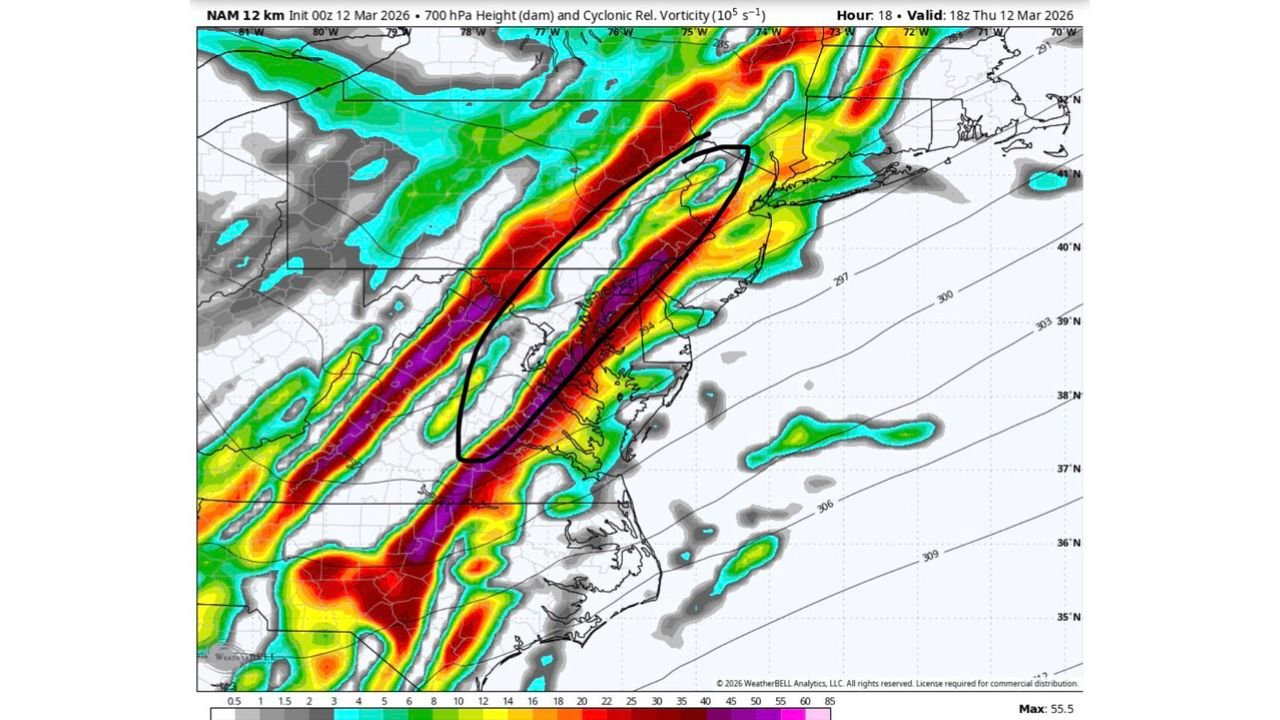
Dynamic Forcing Visible on Model Guidance
Additional forecast panels show enhanced cyclonic vorticity and strong lift aligned through eastern Pennsylvania, central New Jersey, and toward the New York City metro area. This indicates a well-organized upper-level disturbance supporting the precipitation band.
The strongest lift appears concentrated northwest of the immediate coastline, reinforcing that the heaviest snow potential would favor areas just inland from the coastal plain.
Communities farther inland in central Pennsylvania may see more persistent snow, while coastal sections of New Jersey and southern New York could see a quicker return to lighter precipitation as the system exits.
Minimal Accumulation Expected Despite Intensity
Despite the impressive atmospheric setup, forecasters stress that little to no meaningful accumulation is anticipated in major metro areas along I-95.
Factors limiting impacts include:
- Warm ground temperatures
- Daytime solar radiation
- Brief duration of heavy banding
- Rapid system movement
Still, visibility reductions and slick spots cannot be ruled out during the heaviest burst, particularly on bridges and elevated roadways.
For commuters in Pennsylvania, New Jersey, New York, and Maryland, Thursday’s setup may feature a quick-hitting transition from rain to snow before precipitation tapers off.
As this dynamic system moves through the Northeast, residents should stay alert for rapidly changing conditions, especially along heavily traveled corridors.
For continued updates on developing snow bands, rain-to-snow transitions, and major weather impacts across the United States, visit ChicagoMusicGuide.com.