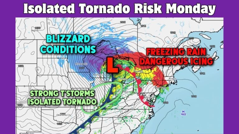
Powerful Sunday–Monday Severe Storm Threat Targets Chicago, St. Louis, Memphis and Charlotte as High Wind Risk and Isolated Tornadoes Loom Along Advancing Front
MEMPHIS, TENNESSEE — A dynamic spring storm system is poised to bring a multi-state severe weather threat from the Midwest to the Southeast, with Sunday focusing on the Mississippi River Valley and Monday shifting into the Carolinas and Mid-Atlantic.
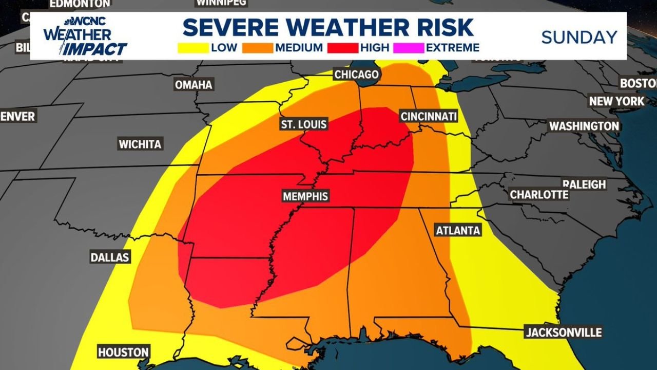
Forecast maps indicate a broad corridor of high-end severe potential centered on St. Louis, Memphis, and areas between southern Illinois and northern Mississippi, before the threat pushes east toward Charlotte, Raleigh, Norfolk, and Washington on Monday.
Forecasters caution that timing of the cold front and storm mode will determine how intense the impacts become.
Sunday Focused on the Mississippi River Valley
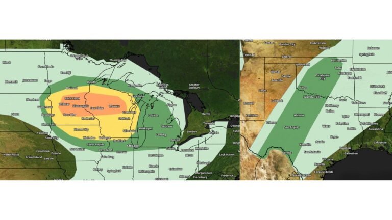
Sunday’s severe weather outlook shows a concentrated zone of higher-end risk stretching from:
- Southern Illinois near St. Louis
- Western Kentucky
- Western Tennessee including Memphis
- Northern Mississippi
- Eastern Arkansas
Chicago and Cincinnati lie on the northern edge of the broader severe corridor, while Atlanta and parts of Alabama remain within the wider risk zone.
The primary hazard appears to be strong straight-line winds, especially if storms consolidate into an organized squall line. Given the strength of the projected wind fields, gusts capable of producing tree damage and power outages are possible.
Isolated tornadoes cannot be ruled out, particularly where embedded rotations form within the line or where storms briefly become discrete ahead of the main boundary.
Memphis to St. Louis in the Bullseye
The most intense risk shading centers on the Mississippi River Valley corridor, placing Memphis and St. Louis in a particularly concerning position.
This region typically becomes vulnerable when strong upper-level wind energy overlaps with surface instability — a setup that appears increasingly likely Sunday afternoon and evening.
Communities along the I-55 and I-40 corridors should be especially alert.
Monday Shifts the Threat East
By Monday, the cold front is forecast to sweep through the Southeast and Mid-Atlantic.
Risk zones expand across:
- Charlotte, North Carolina
- Raleigh, North Carolina
- Charleston, South Carolina
- Norfolk, Virginia
- Washington, DC
Forecast simulations show a broken line of storms advancing through western North Carolina around midday Monday, then progressing east toward the coast through the afternoon and evening.
Again, damaging winds remain the dominant concern, though isolated tornadoes are possible depending on how storms organize ahead of the front.
Timing Will Be Critical
Meteorologists emphasize that subtle shifts in frontal timing could dramatically influence severity.
If the front arrives during peak daytime heating, instability could support stronger storms. If it pushes through earlier or encounters widespread cloud cover, intensity may be more limited.
This uncertainty is particularly relevant for the Carolinas and Virginia on Monday.
Preparedness Is Key
With two consecutive days of severe potential affecting a large portion of the eastern United States, officials urge residents to prepare in advance.
Have at least three reliable ways to receive warnings, especially overnight Sunday into early Monday when storms may impact parts of the Midwest and Ohio Valley after dark.
Review shelter plans and secure outdoor items that could become projectiles in strong winds.
This evolving system carries the potential for widespread impacts from Illinois and Missouri through Tennessee and Mississippi, then into North Carolina and Virginia to begin the new workweek.
Stay with ChicagoMusicGuide.com for continuing updates as this severe weather threat unfolds.