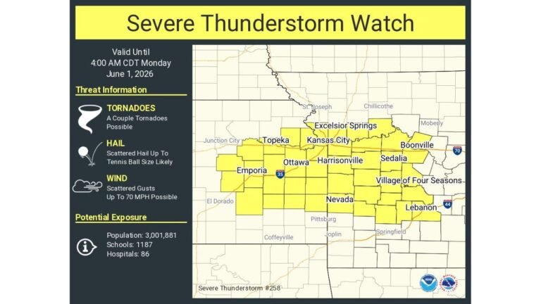
Significant Sunday Severe Weather Threat Intensifies Across Chicago, St. Louis, Memphis and Little Rock as 70+ MPH Winds and Strong EF2+ Tornadoes Become Possible
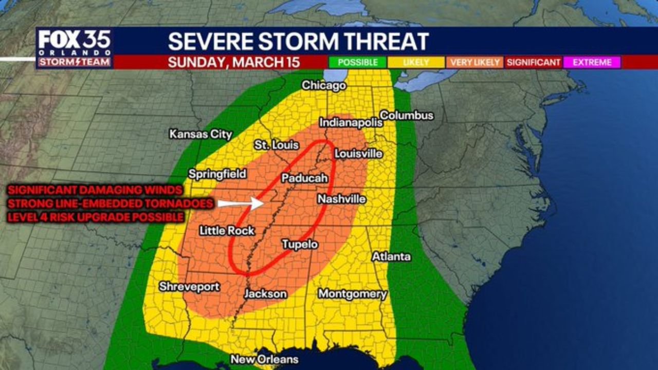
ST. LOUIS, MISSOURI — Sunday is shaping up to be a very significant severe weather day across the Midwest, Heartland, and Mid-South, with a large Level 3 (Enhanced) risk already in place and the possibility of further upgrades if current trends continue.
Forecast guidance shows a narrow, fast-moving, and intense squall line developing Sunday afternoon and racing northeast through the evening hours. The corridor of greatest concern stretches from Little Rock and Shreveport north through Memphis and St. Louis, into southern Illinois and toward Chicago and Indianapolis.
Forecasters warn that this is not a routine spring storm system.
Narrow but Fierce Squall Line Expected
By mid to late Sunday afternoon, a strongly forced band of thunderstorms is expected to organize rapidly along a sharp cold front. This line will likely intensify as it surges east-northeast.
Communities in the core threat zone include:
- Little Rock, Arkansas
- Memphis, Tennessee
- Jackson, Mississippi
- St. Louis, Missouri
- Springfield, Missouri
- Southern Illinois
- Western Kentucky
Significant damaging wind gusts of 70+ mph appear likely in spots. In areas where the line bows outward, localized gusts could exceed that threshold.
Given the speed of the system, impacts may occur quickly with limited time between warning issuance and storm arrival.
Strong Tornado Potential Within the Line
While large squall lines often produce brief and weaker tornadoes, forecasters note that this setup features unusually strong wind shear and dynamic forcing.
In select cases — particularly in environments with enhanced instability — squall lines can produce embedded briefly strong tornadoes (EF2 or higher). Current projections suggest that risk cannot be ruled out Sunday afternoon and evening.
Several tornadoes appear likely within the broader corridor, especially across eastern Arkansas, northern Mississippi, western Tennessee, and parts of southern Illinois.
Upgrade to Level 4 Risk Possible
With the Enhanced Risk already widespread, some meteorologists believe an upgrade to a Level 4 (Moderate) risk is possible if confidence continues to grow in the high-end wind and tornado potential.
The region highlighted for the greatest concern runs from Shreveport and Little Rock through Memphis and into southern Illinois, overlapping key population centers and major transportation corridors.
Snow Flurries Behind the Front
In a dramatic contrast, colder air rushing in behind the powerful front could bring snow flurries Sunday night into Monday morning across parts of Missouri and Illinois.
This sharp temperature drop underscores the strength of the system driving the severe weather threat.
Monday Shifts Threat to the East Coast
As the front sweeps east on Monday, the severe weather risk will spread into the Southeast and along the East Coast.
Areas at risk Monday include:
- Central Florida
- The Carolinas, including Charlotte and Raleigh
- Coastal South Carolina and Georgia
- Portions of Virginia
A tornado risk is possible in Florida Monday afternoon, extending northward through the Carolinas and into parts of Virginia as the system continues east.
Preparation Urged Across Multiple States
With impacts expected from Arkansas and Mississippi through Missouri and Illinois, and then shifting into the Southeast, residents should prepare now.
Ensure multiple ways to receive warnings, review shelter plans, and remain weather aware throughout Sunday and into Monday.
This system carries the potential for widespread damaging winds, embedded tornadoes, and rapid weather changes across a large portion of the eastern United States.
Stay with ChicagoMusicGuide.com for continuing updates as this high-impact severe weather event unfolds.