Illinois, Indiana, Kentucky and Tennessee Face High-Impact Overnight Storm Threat as Powerful Squall Line Targets Memphis, Nashville, Evansville and Indianapolis
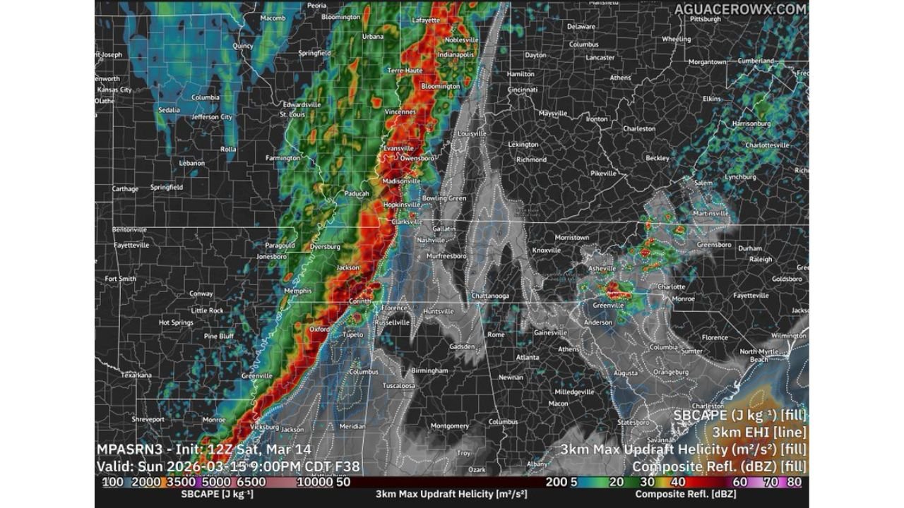
MEMPHIS, TENNESSEE — A dynamically driven severe weather setup is coming together for Sunday night across the Mississippi Valley, with Illinois, Indiana, Kentucky and Tennessee directly in the path of a fast-moving squall line capable of producing significant wind damage and embedded tornadoes.
Newer high-resolution guidance suggests that even in a lower-instability environment, the strength of the forcing and wind fields could compensate — creating a corridor of dangerous storms from Arkansas and Mississippi northward into the lower Ohio Valley.
Low Instability but Extreme Forcing
Forecasters analyzing advanced model guidance note that this is not a classic high-CAPE outbreak. Instead, it is a low-CAPE, high-shear environment.
That means:
- Instability may be modest in some areas
- Wind shear and upper-level dynamics are extremely strong
- Storm organization will rely heavily on large-scale forcing
Even a somewhat narrow or “anemic” squall line in this setup can produce significant wind gusts and embedded tornado circulations.
Line Forms in Arkansas and Mississippi
Model projections show the line consolidating across:
- Western Arkansas
- Northern Louisiana
- Central and western Mississippi
From there, it surges northeast through:
- Memphis, Tennessee
- Jackson, Tennessee
- Evansville, Indiana
- Southern Illinois
- Toward Indianapolis, Indiana
The timing suggests Memphis and northern Mississippi during the evening, Nashville and western Kentucky later at night, and southern Illinois and southern Indiana closer to or after midnight.
Wind Damage Likely the Primary Threat
The most widespread hazard will be damaging straight-line winds, with gust potential exceeding 60 mph and possibly higher in stronger segments.
Because of the powerful jet stream overhead, storms will efficiently transport momentum to the surface.
Communities at risk include:
- Memphis, Tennessee
- Nashville, Tennessee
- Paducah, Kentucky
- Evansville, Indiana
- Vincennes, Indiana
- Bloomington, Indiana
- Springfield, Illinois
This kind of setup can produce long swaths of wind damage along the leading edge of the line.
Tornado Risk Increases Where Instability Is Higher
While damaging wind is the main concern, embedded tornadoes remain possible along the squall line — particularly in zones where instability briefly increases.
Guidance indicates that:
- A few quick spin-ups are possible within the line
- Areas of slightly higher instability could support stronger tornadoes
- A couple of strong tornadoes cannot be ruled out
These tornadoes would likely form quickly and may be difficult to see at night.
Overnight Timing Adds Concern
Much of the highest-impact weather will occur after dark, especially from western Tennessee into Kentucky, southern Illinois and southern Indiana.
That includes heavily populated corridors such as:
- Memphis, Tennessee
- Nashville, Tennessee
- Evansville, Indiana
- Areas south of Indianapolis, Indiana
Nighttime severe weather increases danger because residents are less likely to receive warnings immediately.
Chicago Monitoring Northern Edge
Chicago, Illinois remains near the northern periphery of the stronger dynamics. While the most intense severe threat currently appears focused south of the city, strong storms and gusty winds remain possible as the system lifts northeast.
Residents across Illinois and Indiana should monitor updates carefully as subtle shifts in the instability axis could nudge higher risk areas northward.
Preparation Recommended
With a fast-moving, dynamically supported squall line expected, preparation should happen before sunset Sunday.
Recommended actions include:
- Ensuring weather alerts are enabled
- Charging phones and backup batteries
- Identifying an interior shelter location
- Staying alert for warnings overnight
This is shaping up to be a classic early-spring, high-shear severe event — one capable of producing damaging winds and embedded tornadoes across multiple states.
Stay with ChicagoMusicGuide.com for continuing updates as new model runs refine timing and impact zones heading into Sunday night.