Virginia, Maryland, New York and Pennsylvania Under Threat as Negatively Tilted Jet Stream Fuels 70+ MPH Wind Risk and Tornado Potential Monday
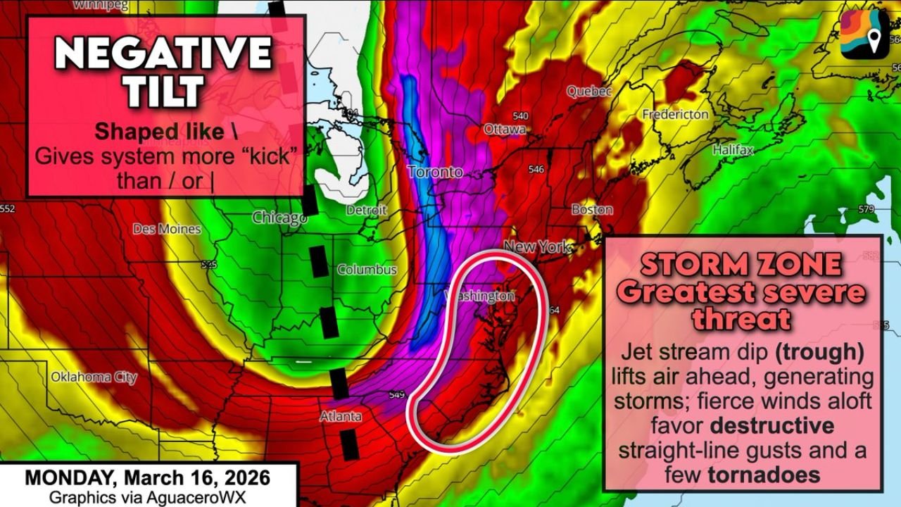
WASHINGTON, D.C., VIRGINIA — A powerful upper-level jet stream configuration is setting the stage for potentially dangerous severe weather across Virginia, Maryland, Pennsylvania and New York on Monday, March 16, as meteorologists monitor a rare and concerning negatively tilted trough swinging through the eastern United States.
Forecasters say the atmospheric setup has the kind of “kick” that can quickly intensify storms — increasing the risk for destructive straight-line winds and at least a few tornadoes across the Mid-Atlantic and Northeast.
What Makes This Setup Concerning
At the heart of the concern is a sharp dip in the jet stream taking on a negatively tilted orientation — meaning it angles from northwest to southeast rather than the more common southwest-to-northeast alignment.
This configuration is often associated with:
- Strong upward motion
- Enhanced wind shear
- Intensifying surface low pressure
- Increased tornado potential
The jet stream energy racing overhead is exceptionally strong, and any thunderstorms forming along the advancing cold front will be able to tap into that momentum and mix it down to the surface.
70+ MPH Wind Gusts Possible
With intense wind energy aloft, forecasters warn that thunderstorms may produce locally destructive wind gusts exceeding 70 mph across parts of:
- Eastern Virginia
- Maryland
- Washington, D.C.
- Eastern Pennsylvania
- New Jersey
- Southern New York
These winds would be capable of downing trees, causing scattered power outages and creating hazardous travel conditions.
Tornado Potential in the Storm Zone
The strongest severe weather corridor appears to arc from northern Georgia through the Carolinas and into:
- Virginia
- Maryland
- The Washington, D.C. metro
- Eastern Pennsylvania
- New Jersey
- New York City
As the negatively tilted trough lifts air ahead of the cold front, storms may rotate more efficiently due to enhanced wind shear. That rotation increases the chance for at least a few tornadoes embedded within the line of storms.
While damaging wind remains the primary threat, the combination of strong shear and sufficient low-level moisture means tornado risk cannot be dismissed.
Greatest Severe Threat Focused Along the Mid-Atlantic Coast
The most intense dynamics appear concentrated along the coastal Mid-Atlantic corridor, especially near:
- Richmond, Virginia
- Washington, D.C.
- Baltimore, Maryland
- Philadelphia, Pennsylvania
- New York City, New York
This zone lies directly beneath the strongest jet streak energy and the most favorable wind shear profile.
Why Negative Tilt Matters
Negatively tilted troughs are often the most volatile storm-producing systems because they:
- Strengthen surface low pressure rapidly
- Increase vertical wind shear
- Promote stronger storm organization
- Enhance severe wind potential
Think of it as an atmospheric follow-through — once the system starts swinging, it carries extra momentum.
Timing and Preparedness
Severe weather is expected to develop Monday as the cold front advances eastward.
Residents across Virginia, Maryland, Pennsylvania and New York should monitor updated forecasts and be prepared for rapidly changing weather conditions.
With the potential for destructive straight-line winds and a few tornadoes, this system demands close attention.
Stay with ChicagoMusicGuide.com for continuing updates as this powerful negatively tilted jet stream system moves through the Mid-Atlantic and Northeast.