Tennessee, Kentucky and Southern Illinois Face 75 to 90 MPH Destructive Wind Line From Memphis and Dyersburg to Carbondale and Mount Vernon
CARBONDALE, ILLINOIS — A dangerous and intensifying line of severe storms is charging northeast through west Tennessee, western Kentucky, and southern Illinois, prompting widespread Severe Thunderstorm Warnings and triggering Wireless Emergency Alerts on mobile phones across the region.
Forecasters warn this is not an ordinary squall line. Straight-line wind gusts between 75 and 90 mph are expected, with the potential for a few briefly strong EF2+ tornadoes embedded within the line. However, the primary concern remains widespread destructive wind damage.
Radar Shows a Violent, Continuous Wind Line
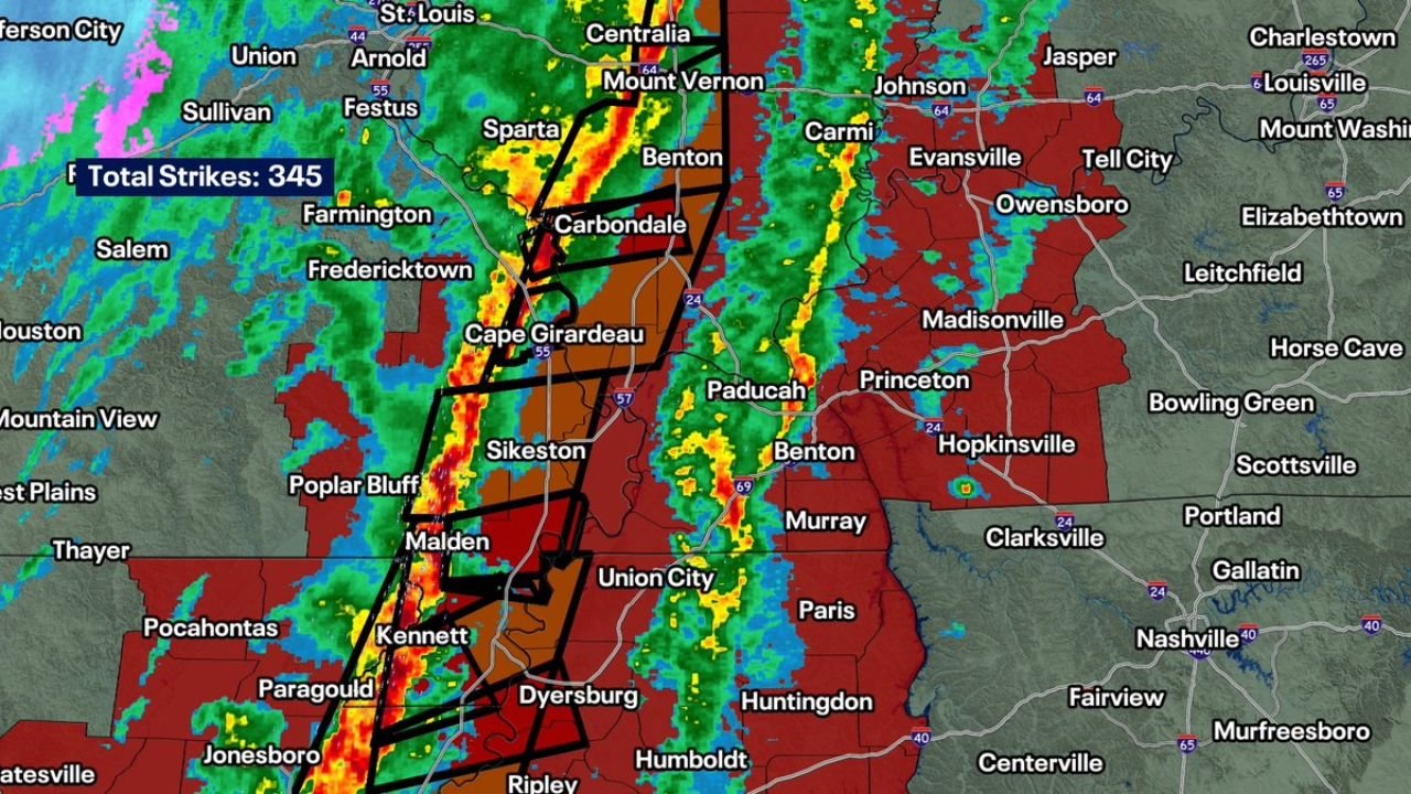
As of early evening, radar imagery shows a tightly organized, bowing line of storms stretching from near Jonesboro, Arkansas, through Dyersburg and Union City, Tennessee, and into Paducah, Kentucky, and Carbondale, Illinois.
Communities directly in the path include:
- Memphis and Dyersburg, Tennessee
- Union City and Paris, Tennessee
- Paducah and Madisonville, Kentucky
- Carbondale, Mount Vernon, and Centralia, Illinois
- Cape Girardeau, Missouri
Warning polygons blanket much of western Tennessee, western Kentucky, and southern Illinois, with red-shaded alerts indicating widespread severe thunderstorm warnings and embedded tornado warnings.
Lightning activity has surged into the thousands of strikes as the line continues organizing and accelerating northeast.
Straight Line Winds the Biggest Danger
While tornadoes are possible, this system is structured primarily as a linear wind event.
Forecasters emphasize residents should shelter as they would during a tornado warning, particularly in areas under destructive severe thunderstorm warnings.
Wind gusts of 75–90 mph are capable of:
- Snapping large trees
- Causing structural roof damage
- Toppling power poles
- Producing extended power outages
- Making travel extremely dangerous
In many cases, damage from these winds can resemble tornado damage, even if no tornado occurs.
Tornado Threat Secondary But Real
Although major, long-track EF4 tornadoes are not anticipated with this setup, a few briefly strong EF2+ tornadoes cannot be ruled out.
Embedded circulations within the line — especially near bowing segments and kinks in the storm structure — may quickly spin up tornadoes with little warning.
Locations near the Mississippi River corridor, including:
- Cape Girardeau, Missouri
- Carbondale, Illinois
- Paducah, Kentucky
- Dyersburg, Tennessee
should remain especially alert as the most intense segment pushes northeast.
Chicago Region Monitoring Southern Illinois Impact
While the core of the most destructive winds is focused across southern Illinois and points south, conditions in that region often influence broader Midwest weather patterns.
Emergency managers in Illinois are closely monitoring impacts in Mount Vernon, Centralia, and Carbondale, where infrastructure damage could disrupt travel corridors and power transmission.
What Residents Should Do Immediately
If you are in west Tennessee, western Kentucky, or southern Illinois:
- Move to an interior room on the lowest floor
- Stay away from windows
- Avoid mobile homes if possible
- Do not attempt to drive through the line
Even without a tornado, winds of this magnitude can be life-threatening.
The storm line will continue racing northeast through the evening hours, gradually weakening overnight — but not before delivering potentially widespread damage across parts of Tennessee, Kentucky, and Illinois.
Stay with ChicagoMusicGuide.com for continuing severe weather updates as this powerful wind event unfolds across the Mid-South and lower Midwest.