Illinois, Missouri and Indiana Transition From 80 MPH Severe Wind Line to Heavy Snow Near St Louis and Chicago as Storm Races East Toward Kentucky and Tennessee
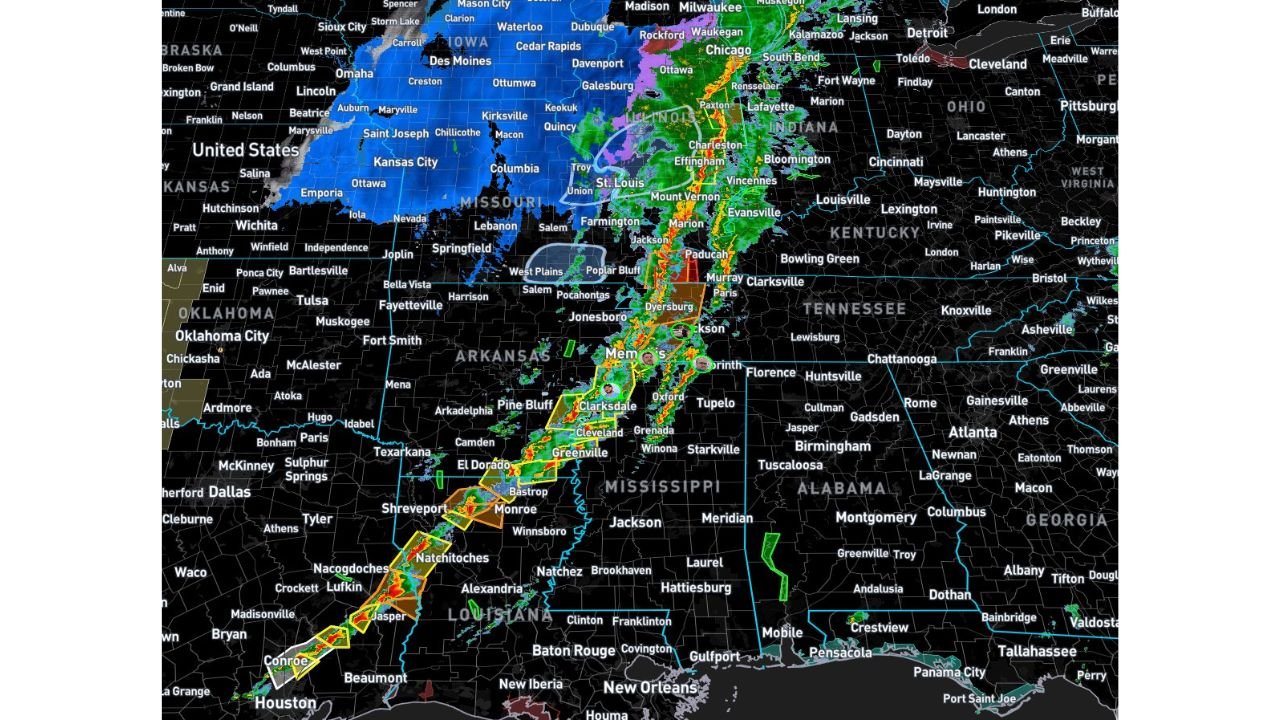
ST. LOUIS, MISSOURI — A sprawling and powerful storm system continues to surge eastward across the central United States tonight, bringing a dramatic mix of destructive winds, isolated tornadoes, and now heavy snow on its backside across parts of Missouri, Illinois, Indiana, Kentucky, Tennessee, Arkansas, Louisiana, and Iowa.
The main severe line — stretching from Louisiana through Mississippi and Arkansas into western Tennessee and western Kentucky — is producing wind gusts of 60 to 80 mph, with a few tornadoes possible through around midnight.
Destructive Wind Line From Louisiana to Kentucky
Radar imagery shows a solid, bowing line of severe storms extending from:
- Near Houston and Jasper, Texas
- Through Shreveport and Monroe, Louisiana
- Into Greenville and Clarksdale, Mississippi
- Across Memphis, Tennessee
- Through Paducah, Kentucky
Warnings continue along the corridor from Natchitoches, Louisiana, to Memphis, Tennessee, and up toward western Kentucky.
Straight-line wind damage remains the primary threat. Embedded circulations may still produce brief tornadoes, but the broader concern is widespread wind impacts capable of downing trees and causing power outages.
Memphis and Paducah in the Crosshairs
Cities including:
- Memphis, Tennessee
- Dyersburg, Tennessee
- Jonesboro, Arkansas
- Paducah, Kentucky
- Murray, Kentucky
remain in the path of the most intense segment of the line as it pushes northeast.
Forecasters indicate the pre-frontal supercell threat earlier in the evening did not fully organize as feared, limiting the potential for more intense long-track tornadoes. Instead, the event has evolved into a powerful wind-driven squall line.
Heavy Snow Replaces Storms Across Missouri and Iowa
Behind the severe line, colder air has surged southward and westward across:
- St. Louis, Missouri
- Columbia, Missouri
- Springfield, Missouri
- Kansas City, Missouri
- Des Moines, Iowa
Radar shows widespread snow, including pockets of heavier snowfall north and west of St. Louis and into central Missouri and southern Iowa.
Some areas that experienced severe weather earlier are now transitioning to accumulating snow as the cold air wraps in behind the system.
Illinois and Indiana See Both Sides of the System
In Illinois, locations such as:
- Mount Vernon
- Marion
- Effingham
- Centralia
remain near the dividing line between heavy rain and mixed precipitation.
Farther north toward Chicago and Rockford, rain and mixed precipitation continue, with colder air gradually filtering south.
In Indiana, communities including:
- Vincennes
- Bloomington
- Lafayette
are experiencing heavy rain and strong storms ahead of the snow shield to the northwest.
What Happens Next
The severe threat across Tennessee and Kentucky will continue into the late evening hours, with damaging winds remaining the top concern until around midnight.
Meanwhile, snow will expand and intensify across parts of Missouri and Iowa, creating rapidly deteriorating travel conditions overnight.
This system highlights a classic March transition storm — severe weather on the warm side, winter weather on the cold side — impacting multiple states simultaneously.
Residents across Illinois, Missouri, Indiana, Kentucky, Tennessee, Arkansas, Louisiana, and Iowa should remain alert for rapidly changing conditions as this powerful storm system continues its eastward march.
Stay with ChicagoMusicGuide.com for continued severe weather and winter storm updates across the Midwest and Mid-South.