Washington and Oregon Face Major Snowmelt Flood Threat as Atmospheric River Targets Seattle, Portland and Cascade Mountains With Several Inches of Rain
SEATTLE, WASHINGTON — After several days of heavy mountain snowfall across Washington and Oregon, a powerful atmospheric river is now poised to drench the Pacific Northwest with widespread rain — raising serious concerns about rapid snowmelt and potential flooding.
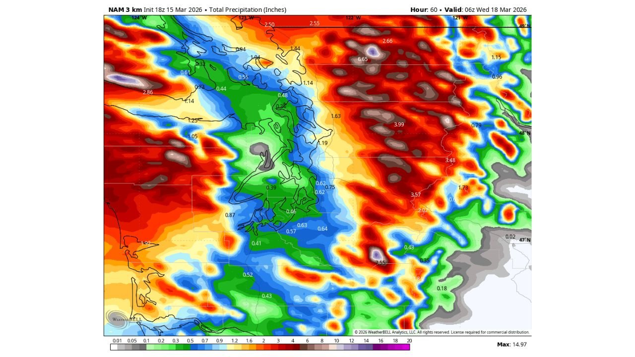
Forecast models show multiple inches of precipitation falling across western Washington and western Oregon, with much of it expected to fall as rain — even in areas that recently measured snowfall in feet.
From Snowfall to Rapid Melt
The Cascades and higher terrain across:
- The Washington Cascades
- The Oregon Cascades
- Parts of the Olympic Mountains
have accumulated substantial fresh snow over the past several days.
Now, warmer Pacific air associated with an atmospheric river is expected to surge inland, pushing snow levels higher and turning much of the incoming precipitation into rain.
That combination — heavy rain falling on fresh snowpack — significantly increases the risk of:
- Rapid snowmelt
- Elevated river levels
- Urban flooding
- Landslides in steep terrain
Several Inches of Rain Forecast
Precipitation projections show widespread totals exceeding:
- 2 to 4 inches across western Washington
- 2 to 5 inches across western Oregon
- Locally higher totals in mountainous areas
Heaviest rainfall appears focused along the coastal ranges and west-facing slopes of the Cascades, including areas near:
- Seattle, Washington
- Tacoma, Washington
- Portland, Oregon
- Eugene, Oregon
While some higher elevations may initially see mixed precipitation, most of the incoming moisture is expected to fall as rain.
Rivers and Lowlands on Alert
Rivers draining the Cascades — including systems feeding into the Puget Sound region and the Willamette Valley — could respond quickly.
Urban areas such as:
- Seattle
- Olympia
- Portland
- Salem
may experience localized flooding in poor drainage areas if rainfall rates intensify.
The timing of the heaviest rainfall aligns with the period of peak warming aloft, increasing the likelihood that snowpack below higher elevations will melt rapidly.
Why This Setup Is Concerning
Atmospheric rivers transport concentrated bands of Pacific moisture directly into the West Coast.
When paired with:
- Recently accumulated mountain snow
- Rising freezing levels
- Sustained rainfall
the risk shifts from winter storm impacts to flood impacts almost immediately.
The transition from feet of snow to heavy rain can strain waterways and increase runoff much faster than rain alone.
What Residents Should Watch For
Residents across Washington and Oregon should monitor:
- River forecasts
- Flood advisories
- Rapid rises in streams and creeks
- Travel conditions in mountain passes
Those in flood-prone areas should prepare for potential water accumulation, especially if heavier rainfall bands stall.
This developing atmospheric river event highlights how quickly the Pacific Northwest can pivot from winter storm conditions to flood threats.
Stay with ChicagoMusicGuide.com for continued updates as heavy rain moves into Washington and Oregon and snowmelt concerns increase across the Cascades.