New York Pennsylvania New Jersey Massachusetts and Connecticut Brace for Sharp Cold Snap as Powerful March Trough Ends Warm Spell
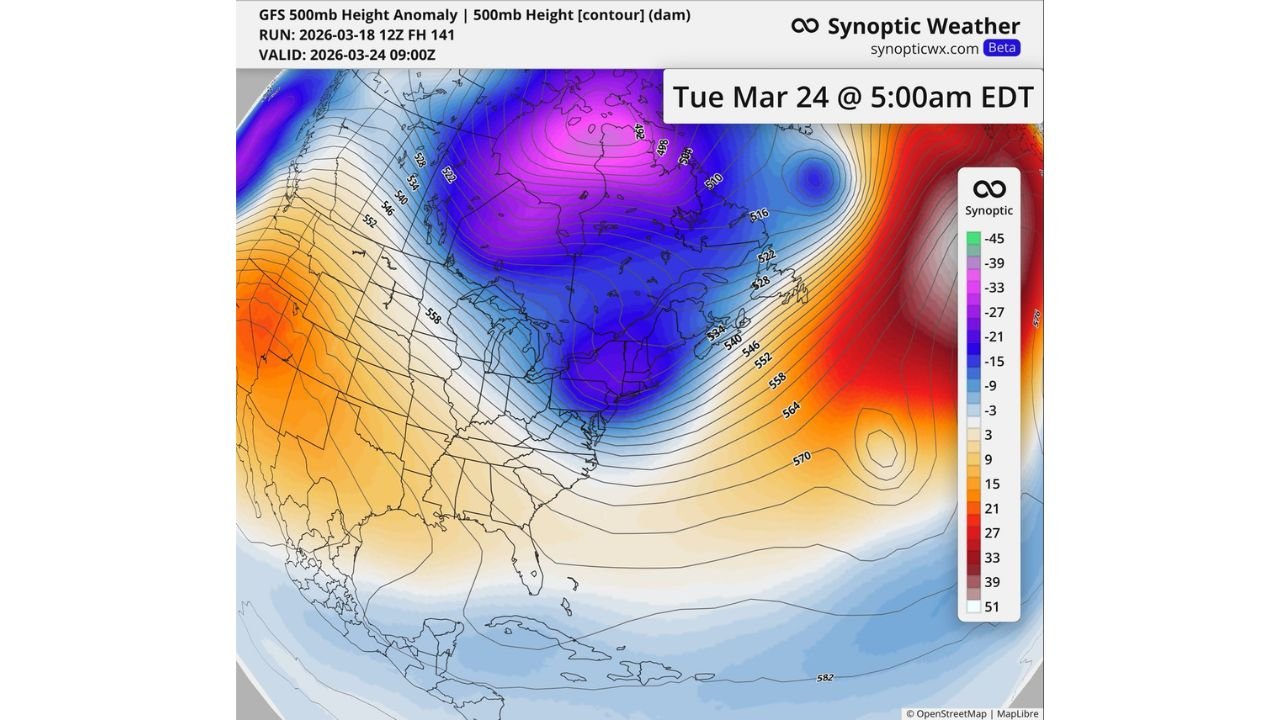
NORTHEAST UNITED STATES — After an extended stretch of unusual warmth across much of the eastern U.S., a strong upper-level trough is set to swing into the Northeast by Tuesday, March 24, bringing a noticeable return to seasonal temperatures—and possibly even below-normal conditions—for a brief period.
Forecast data shows a deep trough carving into the region, with cooler air spilling southward from Canada into the Great Lakes, Mid-Atlantic, and Northeast states, marking a sharp but short-lived pattern shift.
Powerful Trough Signals Sudden Pattern Change
Upper-level analysis indicates a pronounced dip in the jet stream, with strong negative height anomalies centered over eastern Canada and the northeastern U.S.
This setup allows colder air to surge into states including:
- New York
- Pennsylvania
- New Jersey
- Massachusetts
- Connecticut
- Vermont and New Hampshire
The arrival of this trough represents a classic late-winter pattern, temporarily reversing the recent trend of above-normal temperatures.
Temperatures Expected to Drop Back Toward Normal Levels
After days of mild to warm conditions, the incoming system is expected to bring temperatures back to near-normal levels for late March, with some areas potentially dipping slightly below average for a short window.
This shift may not be extreme in terms of absolute cold, but the contrast will be noticeable—especially following the recent warmth that has dominated much of the eastern half of the country.
Meteorologists note that such swings are typical during the transition from winter to spring, when competing air masses frequently clash.
Brief Cooldown Likely to Last Only a Few Days
Despite the strength of the trough, current projections suggest the cooldown will be temporary, lasting only one to two days before temperatures begin moderating again.
This type of quick “reset” in temperatures—often measured in heating degree days (HDDs)—is common late in the season and reflects the atmosphere attempting to rebalance after extended warmth.
Great Lakes and Mid-Atlantic Also Impacted
The cooling influence will extend beyond the Northeast, affecting a broader region that includes:
- Great Lakes states such as Michigan and Ohio
- Mid-Atlantic regions including Maryland and Virginia
These areas will also experience a return to more typical late-March conditions, though impacts will vary depending on local geography and timing.
Late-Season Reminder That Winter Isn’t Fully Gone
While spring is approaching, this pattern reinforces that winter-like influences can still briefly return, especially when strong upper-level systems move through.
The incoming trough serves as a reminder that seasonal transitions are rarely smooth, often featuring abrupt swings between warmth and cooler air.
What This Means Going Forward
Although the cooldown is not expected to persist, it could play a role in:
- Slowing early vegetation growth
- Temporarily increasing heating demand
- Reinforcing the variability of early spring weather patterns
As the system moves through, attention will turn to how quickly warmth rebounds and whether additional troughs follow.
For now, residents across the Northeast United States should prepare for a short-lived but noticeable return to cooler conditions early next week.
Stay with ChicagoMusicGuide.com for continued updates on shifting U.S. weather patterns.