Texas, Oklahoma, Kansas, Missouri and Illinois Could See Early-April Severe Weather Surge as Powerful Jet Stream Targets the Midwest and Mississippi Valley
TEXAS — Long-range ensemble guidance is signaling a potentially active pattern developing for the first week of April across the central and eastern United States, with the jet stream strengthening over the Plains and Midwest — a classic setup for severe thunderstorms and possible tornado outbreaks.
After a relatively quiet stretch in the near term, forecasters are closely watching signals that point toward a notable uptick in severe weather across Texas, Oklahoma, Kansas, Missouri, Arkansas, Illinois and surrounding states around April 1–5.
Strengthening Jet Stream Over the Plains and Midwest
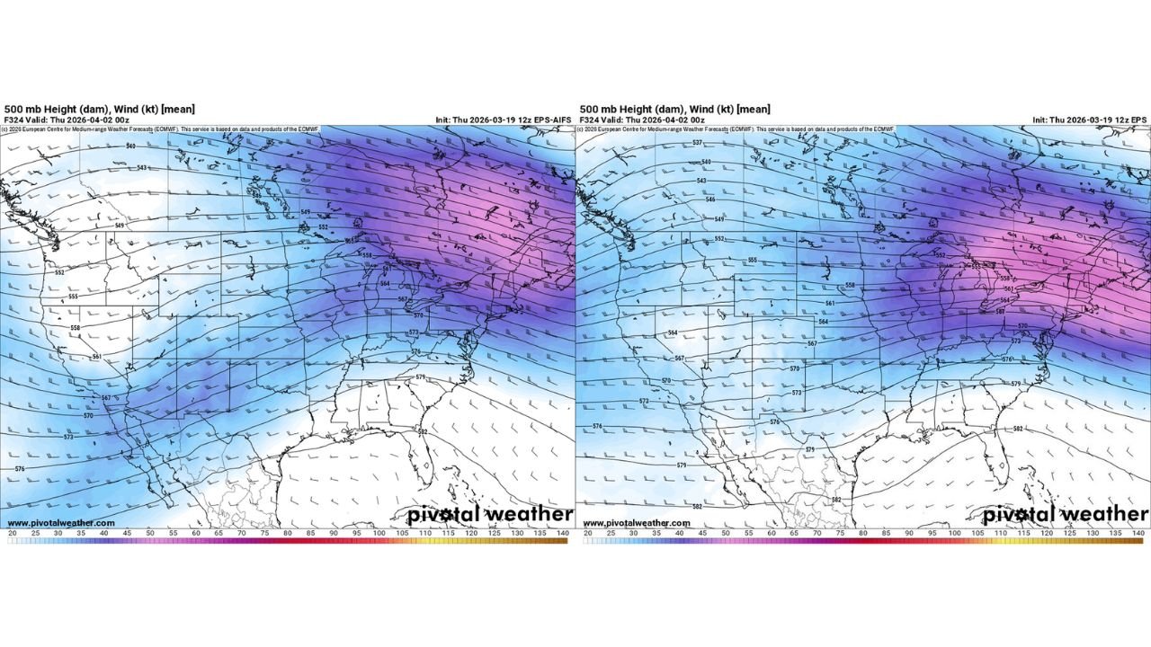
500mb height and wind projections show a broad trough carving into the western and central U.S., with increasing mid-level wind speeds extending from New Mexico and Texas northeastward into Kansas, Missouri, Illinois, Indiana and Ohio.
Stronger upper-level winds are a key ingredient for organized severe weather. When combined with Gulf moisture and surface instability, this pattern can support:
- Supercell thunderstorms
- Large hail
- Damaging winds
- Tornado potential
The ensemble mean wind fields show consistent southwest-to-northeast flow over the central U.S., a configuration often associated with spring severe weather events.
Texas to Illinois: Corridor of Concern Emerging
The most favorable overlap zone appears to stretch from:
- North and Central Texas
- Oklahoma
- Kansas
- Missouri
- Into Illinois and possibly Indiana
This corridor aligns with early-season climatology for severe weather and suggests the Midwest — including Chicago and much of Illinois — could be on the northern edge of organized thunderstorm activity if the pattern materializes as currently projected.
Mississippi Valley and Ohio Valley Also in Play
Guidance also shows enhanced upper-level flow reaching into:
- Arkansas
- Tennessee
- Kentucky
- Indiana
- Ohio
If sufficient instability builds northward from the Gulf of Mexico, severe storms could extend deeper into the Midwest and lower Great Lakes region.
While details such as timing, exact storm mode, and tornado probability remain uncertain at this range, the large-scale pattern supports increasing vigilance.
Why the Pattern Is Turning Active
The setup features:
- A western U.S. trough
- Broad southwest flow aloft
- Increasing mid-level wind speeds
- Potential Gulf moisture return
This combination is often a precursor to early-April severe weather episodes across the central U.S.
Additionally, model consistency across ensemble members increases confidence that the first week of April will be more active than the final week of March.
Chicago and Northern Illinois: Watching the Northern Fringe
For Chicago and northern Illinois, the primary question will be how far north instability can advance.
If moisture transport is robust and surface temperatures warm sufficiently, strong to severe thunderstorms could reach into the region. If instability remains suppressed farther south, Illinois may primarily experience heavy rain and gusty storms without widespread severe impacts.
Either way, the atmospheric pattern appears primed for increased thunderstorm development.
Quiet for Now — But Not for Long
Forecasters emphasize that the period between now and late March looks relatively calm. However, the shift into April could bring:
- Multiple storm systems
- Stronger wind fields
- Greater severe weather potential
From Texas and Oklahoma through Kansas, Missouri and Illinois, residents should prepare for a potentially more volatile start to April.
Stay with ChicagoMusicGuide.com for continued updates as forecast confidence increases and more precise severe weather outlooks become available for the Midwest and central United States.