Nebraska, South Dakota, Wyoming, and Colorado Under Critical Fire Weather Threat as High Plains Face Extreme Spread Risk Through Saturday
NORTH PLATTE, NEBRASKA — Elevated to critical fire weather conditions are in place across portions of the northern and central High Plains, with the most dangerous conditions centered on Nebraska, South Dakota, eastern Wyoming, and northeastern Colorado through Saturday. Forecasters warn that very low relative humidity, combined with strong downslope winds off the Rockies, could lead to extreme fire behavior and rapid wildfire spread.
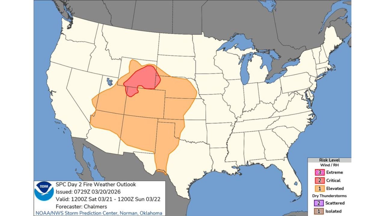
The latest Storm Prediction Center Fire Weather Outlook highlights a concentrated critical risk zone stretching across western and central Nebraska into southern South Dakota, with broader elevated conditions expanding across Wyoming, Colorado, Kansas, and parts of the central Plains.
Day 1: Critical Conditions Focused on Nebraska and South Dakota
For Friday into early Saturday, the most intense fire weather threat is centered over western and central Nebraska, extending northward into southern South Dakota and westward toward eastern Wyoming.
Meteorologists attribute the heightened risk to a combination of:
- Very low relative humidity values
- Strong, gusty winds
- Dry fuels and ongoing drought conditions
- Downsloping air off the Rocky Mountains
Downslope winds compress and warm as they descend, further drying the air mass. This process creates an environment where any ignition could spread quickly, particularly across open grasslands common to the High Plains.
Day 2: Elevated Risk Expands Across the Central High Plains
By Saturday into early Sunday, the broader elevated fire weather area expands significantly. The risk spreads across much of Nebraska, South Dakota, Wyoming, Colorado, western Kansas, and portions of New Mexico and Texas.
Although the core critical zone remains focused in parts of the northern High Plains, elevated conditions cover a much larger footprint. This indicates continued dry air and persistent winds, keeping fire danger high across the region.
Communities in Cheyenne, Rapid City, Scottsbluff, North Platte, and eastern Colorado towns should remain alert as conditions favor rapid fire growth.
What Is Driving the Extreme Fire Behavior Risk
The High Plains are experiencing a classic early-season fire weather setup. Strong pressure gradients are producing sustained winds, while relative humidity values are expected to drop to dangerously low levels during peak heating hours.
When paired with dry grasses and vegetation, this combination can lead to:
- Fast-moving grass fires
- Rapid directional shifts if winds change
- Difficulty in containment efforts
Forecasters stress that even small sparks — from machinery, vehicles, or outdoor burning — could escalate into dangerous fires under these atmospheric conditions.
Brief Improvement Sunday Before Conditions Deteriorate Again
Weather models indicate that conditions may briefly improve on Sunday, as winds relax and moisture modestly increases across parts of the High Plains. However, meteorologists caution that this improvement will likely be temporary.
Poor fire weather conditions are projected to return early next week, suggesting an extended period of elevated wildfire concern for the region.
Residents across Nebraska, South Dakota, Wyoming, and Colorado are urged to avoid outdoor burning and exercise extreme caution with any activity that could produce sparks.
As the High Plains navigate this period of critical fire danger, staying informed and prepared remains essential. For continued updates on fire weather alerts, severe weather outlooks, and national forecast analysis, visit ChicagoMusicGuide.com.