Austin, San Antonio and Central Texas Eye Wetter-Than-Normal Pattern as Climate Prediction Center Signals Early April Rain Surge
AUSTIN, TEXAS — A potential pattern shift may be on the horizon for Central Texas as the Climate Prediction Center (CPC) continues to highlight a wetter-than-normal trend developing in early April.
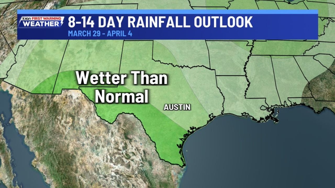
The latest 8–14 day rainfall outlook for March 29 through April 4 shows a broad swath of above-normal precipitation probabilities stretching across Central and South Texas, including Austin and surrounding communities.
CPC Outlook Signals Pattern Change
The CPC’s extended-range guidance suggests increasing confidence in a more active storm track emerging across Texas as March transitions into April.
While the outlook does not provide exact rainfall totals or specific storm timing, the green-shaded region across much of Texas indicates a higher likelihood of rainfall exceeding climatological averages during the period.
The core of the wetter signal appears centered over:
- Austin
- Much of Central Texas
- Portions of South Texas extending toward the Gulf Coast
Too Early for Specific Storm Details
Forecasters emphasize that this outlook remains broad in nature.
At this range, it is too far out to determine:
- Exact storm systems
- Precise rainfall amounts
- Severe weather potential
However, the persistence of the wetter-than-normal signal in consecutive outlooks suggests a meaningful shift in atmospheric patterns could be underway.
Implications for Central Texas
If the wetter pattern materializes, it could bring:
- Increased chances for multiple rounds of showers and thunderstorms
- Improved soil moisture in areas that have been dry
- Potential localized flooding concerns if heavier storms develop
Late March and early April often mark a transition toward more active spring weather across Texas, and this outlook aligns with that seasonal shift.
Watching for an Active Early April
While confidence in above-normal rainfall is growing, meteorologists will continue refining the forecast as the timeframe draws closer.
For residents in Austin, San Antonio, and across Central Texas, the takeaway is clear: the pattern may turn wetter heading into early April, though the specifics remain uncertain.
As updated model data and shorter-range forecasts come into focus, clearer details regarding timing and potential storm intensity will emerge.
For ongoing coverage of developing weather patterns across Texas and the United States, stay with ChicagoMusicGuide.com.