Michigan, Indiana and Ohio Stay Largely Quiet This Week as Storm Track Dips South Toward Kentucky and Tennessee, With Northern Michigan Watching for Possible Snow
MICHIGAN — No major severe weather or widespread winter storm is anticipated across Michigan this upcoming week, but forecasters are closely monitoring Thursday as models hint at developing instability just to the south.
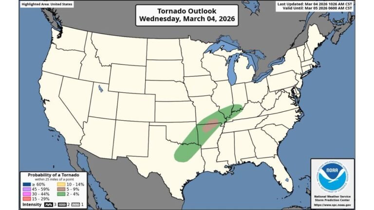
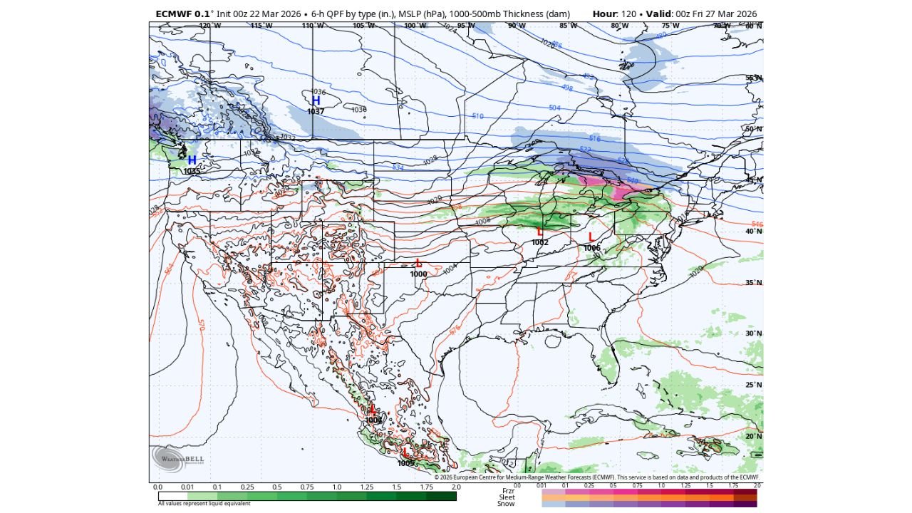
Current projections show the more active weather pattern focusing across Kentucky, Tennessee, southern Indiana and southern Ohio, while most of Michigan remains on the cooler and more stable side of the system — at least for now.
Storm System Tracks South of the State
Model guidance valid late this week shows a developing low-pressure system centered near the Ohio Valley, with rain and embedded instability stretching from Missouri through Kentucky and into parts of Tennessee and West Virginia.
The heaviest precipitation signals appear concentrated south of the Michigan border, with:
- Widespread rain across Kentucky and Tennessee
- Stronger dynamics near southern Indiana and southern Ohio
- Mixed precipitation north of the primary low track
For southern Michigan — including cities such as Detroit, Lansing and Grand Rapids — current projections keep the more robust instability and severe potential south of the state line.
Northern Michigan Watching for Snow Potential
While lower Michigan may avoid major impacts, colder air positioned across the Upper Midwest and Great Lakes raises the possibility of snow across northern portions of Michigan, especially closer to the Straits and eastern Upper Peninsula.
Temperature thickness lines and surface pressure patterns suggest:
- Colder air remains entrenched over northern Michigan and Wisconsin
- A rain-to-snow transition zone could set up near or just north of central Michigan
- Accumulation potential remains uncertain and dependent on the exact storm track
At this time, confidence in significant snowfall totals is low, but a wintry mix or light snow cannot be ruled out for northern counties.
No Major Severe Setup for Michigan — For Now
Although models show some atmospheric instability forming Thursday, the core ingredients for organized severe weather appear focused farther south.
States currently more favored for stronger storms include:
- Kentucky
- Tennessee
- Southern Indiana
- Southern Ohio
Michigan’s position north of the primary warm sector limits the severe threat unless the system trends farther north in upcoming model runs.
Pattern Remains Fluid
Because this system is still several days out, subtle shifts in the low-pressure track could adjust precipitation type and placement. A northward shift would increase rain chances and possibly elevate storm concerns for southern Michigan, while a southward trend would further reduce local impacts.
For now, the forecast favors:
- No major winter storm
- No widespread severe weather in Michigan
- A conditional snow chance in northern areas
- Stronger storm focus remaining south of the state
ChicagoMusicGuide.com will continue monitoring forecast updates and provide refinements as newer model data becomes available later this week.