Illinois, Indiana, Missouri, Arkansas and Texas Face Soaking Rains and Persistent Above-Normal Warmth as Wet and Stormy Pattern Rebuilds Across Central United States
UNITED STATES — After a relatively drier stretch this week in parts of the Midwest and Great Lakes, forecast models indicate that next week will ramp back up with increasing rainfall and continued above-normal warmth across much of the central United States.
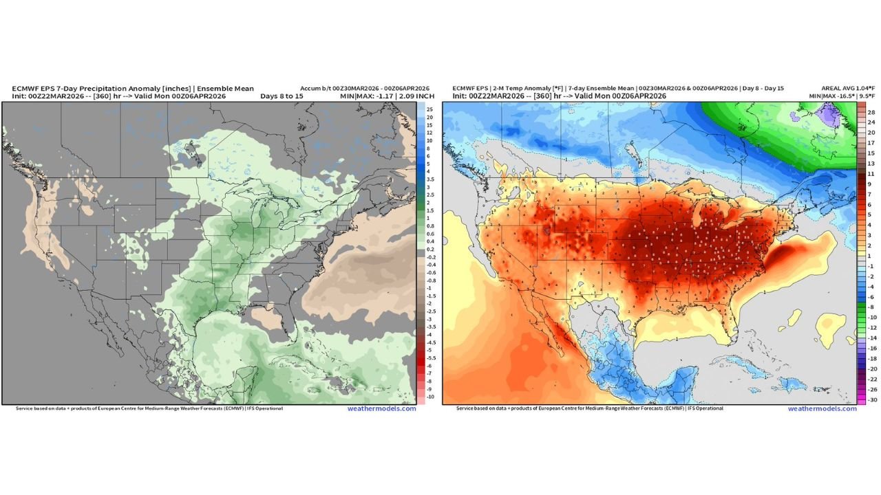
Ensemble guidance for the Day 8–15 period shows a broad zone of wetter-than-average conditions setting up from Texas and Arkansas north through Missouri, Illinois, Indiana and into the Great Lakes, while temperatures remain well above seasonal norms across a large portion of the country.
Widespread Warmth Expands Across the Midwest and Plains
Temperature anomaly projections highlight a substantial warm dome stretching across:
- Illinois
- Indiana
- Missouri
- Iowa
- Kansas
- Nebraska
- Arkansas
- Kentucky
- Tennessee
- Ohio
- Pennsylvania
- New York
Many of these areas are forecast to average 5 to 10 degrees above normal, with some pockets potentially exceeding that threshold during the period.
The warmest anomalies appear centered over the Midwest and Ohio Valley, where deep red shading on ensemble maps indicates persistent and widespread warmth.
Meanwhile, cooler-than-average conditions are projected to remain confined to parts of southern Canada and northern Mexico, keeping the core of the U.S. solidly in the warmer air mass.
Rainfall Increases Across the Central Corridor
Precipitation anomaly guidance shows above-average rainfall building across:
- Eastern Texas
- Arkansas
- Missouri
- Illinois
- Indiana
- Michigan
- Wisconsin
- Louisiana
- Mississippi
Green shading across the Mississippi Valley and into the Great Lakes signals a return to a more active storm track.
This suggests multiple systems may track from the Southern Plains into the Midwest, bringing rounds of rain and potentially embedded thunderstorms.
By contrast, portions of the Southeast Atlantic Coast and parts of the Southwest appear closer to neutral or slightly below-normal precipitation.
Pattern Transition: From Dry to Active
While parts of the Midwest are experiencing a brief lull in rainfall this week, the projected shift toward a wetter regime indicates the jet stream will likely reposition in a way that favors repeated disturbances moving through the central U.S.
This kind of setup often results in:
- Repeated rain events rather than a single storm
- Elevated river and stream levels over time
- Increased thunderstorm chances as warmth and moisture combine
The combination of sustained warmth and periodic rainfall can also promote rapid spring growth and volatile temperature swings between systems.
What This Means for the Great Lakes and Chicago Region
For the Great Lakes, including Illinois, Indiana and Michigan, the outlook favors:
- Continued above-normal temperatures
- Increasing cloud cover at times
- A more unsettled pattern heading into early April
While specific storm timing remains uncertain this far out, the overall signal is clear: the drier window is temporary, and a more active central U.S. pattern is poised to return.
ChicagoMusicGuide.com will continue tracking the developing warmth and rainfall pattern as higher-resolution guidance refines storm timing and intensity in the days ahead.