Utah, Nevada Rain Returns as Salt Lake City and St. George Dry Spell Ends With Incoming Storm Systems
UTAH — After weeks of dry conditions, Salt Lake City and St. George are finally expected to see measurable precipitation as an active weather pattern develops across Utah and parts of Nevada next week. The long-standing dry stretch—lasting nearly three weeks in Salt Lake City and over a month in St. George—may soon come to an end as multiple storm systems move through the region.
Forecasters indicate that rainfall and even mountain snow are likely between Tuesday, March 31, and Friday, April 3, bringing much-needed moisture to the state.
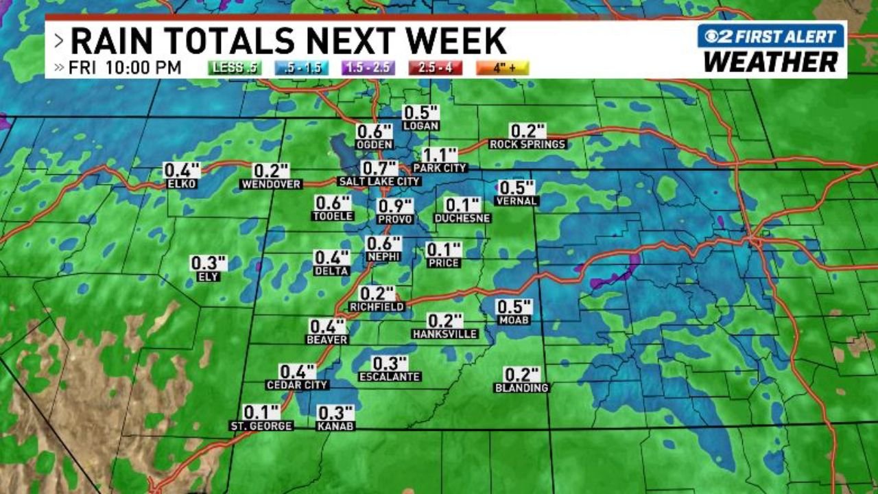
Rain Totals and Snowfall Expectations Across Utah
Forecast models show a widespread but generally moderate precipitation event across Utah, with varying totals depending on location. Areas along the Wasatch Front, including Salt Lake City, are expected to receive around 0.6 to 0.7 inches of rain, while nearby locations such as Provo could see close to 0.9 inches.
Higher elevations, particularly around Park City, may receive over 1 inch of precipitation, much of which could fall as snow in the mountains. Meanwhile, northern areas like Ogden and Logan are forecast to pick up between 0.5 and 0.6 inches.
In contrast, southern parts of the state—including St. George and Kanab—are expected to receive lighter totals, generally around 0.1 to 0.3 inches, though even these amounts will be significant given the prolonged dry period.
Two Storm Systems to Bring Much-Needed Moisture
The incoming pattern is expected to feature two separate storm systems moving across Utah and the surrounding region, creating an unsettled stretch of weather over several days. This multi-day setup increases the likelihood of consistent precipitation rather than a single brief event.
The first system is expected to initiate precipitation early in the week, followed by a second wave that reinforces moisture across the state. This type of pattern is particularly beneficial for easing dry conditions, as it allows for more widespread coverage and better soil absorption.
The inclusion of mountain snow is also critical, especially for water supply concerns, as snowpack plays a major role in long-term water availability across the western United States.
Dry Spell Finally Breaking Across Key Cities
The significance of this forecast lies in how long many parts of Utah have gone without measurable precipitation. Salt Lake City has experienced nearly three consecutive weeks without meaningful rainfall, while St. George has gone even longer, exceeding a full month.
This extended dry period has contributed to increasing concerns about early-season dryness, especially as spring approaches. The upcoming precipitation event could provide an important reset, helping to improve soil moisture levels and reduce short-term drought concerns.
While totals may not be extreme, the consistency and coverage of rainfall are expected to deliver noticeable relief across much of the state.
What This Means for the Region Moving Forward
Although this event is not expected to completely eliminate dry conditions, it represents a critical shift in the weather pattern. The transition from prolonged dryness to an active storm track suggests that additional opportunities for precipitation may follow in the coming weeks.
Residents across Utah and nearby Nevada should prepare for changing conditions, including cooler temperatures, periods of rain, and potential snow in higher elevations. Travel in mountainous areas could be impacted depending on snowfall intensity.
For now, the focus remains on the return of moisture—something many parts of the region have been waiting for after an extended dry stretch.
Stay updated on major weather changes, regional forecasts, and climate trends by visiting ChicagoMusicGuide.com for more in-depth coverage and updates.