Kansas, Oklahoma and Missouri Face a Potentially Significant Severe Weather Day on April 3 With All Hazards Including Tornadoes in Play as Model Agreement Grows Across the Central Plains
WICHITA, KS — The atmosphere is starting to make up its mind about April 3rd — and what it is pointing toward across the central Plains is a setup that demands full attention from anyone living between Kansas, Oklahoma and Missouri. Growing model agreement is now locking in on a shortwave energy ejection into the Plains on Friday, April 3rd, with all severe weather hazards on the table including damaging winds, large hail and tornadoes. This is the most significant severe weather day in the current early April stretch — and it is close enough now to start taking seriously.
Why April 3rd Is Standing Out Above Every Other Day This Week
Multiple severe weather days are expected both before and after April 3rd across the central United States. But of all the setups in this active stretch, Friday is the one that the current atmospheric data is flagging as the most favorable. Here is why.
A shortwave trough — think of it as a concentrated burst of energy moving through the upper atmosphere — is now showing growing agreement among models to eject into the Plains on April 3rd. When a shortwave moves in at the right angle and at the right speed, it acts like a trigger for the atmosphere below. It forces air upward rapidly, destabilizes the column and provides the lift needed to fire severe thunderstorms that can become organized and long-lived.
The timing of this shortwave ejection relative to surface low development across the Plains is what makes April 3rd particularly dangerous if the pattern holds. When upper-level energy and surface cyclogenesis arrive together, the result is a storm environment capable of supporting supercell thunderstorms — the type of storm responsible for the majority of significant tornadoes and giant hail reports across Tornado Alley every spring.
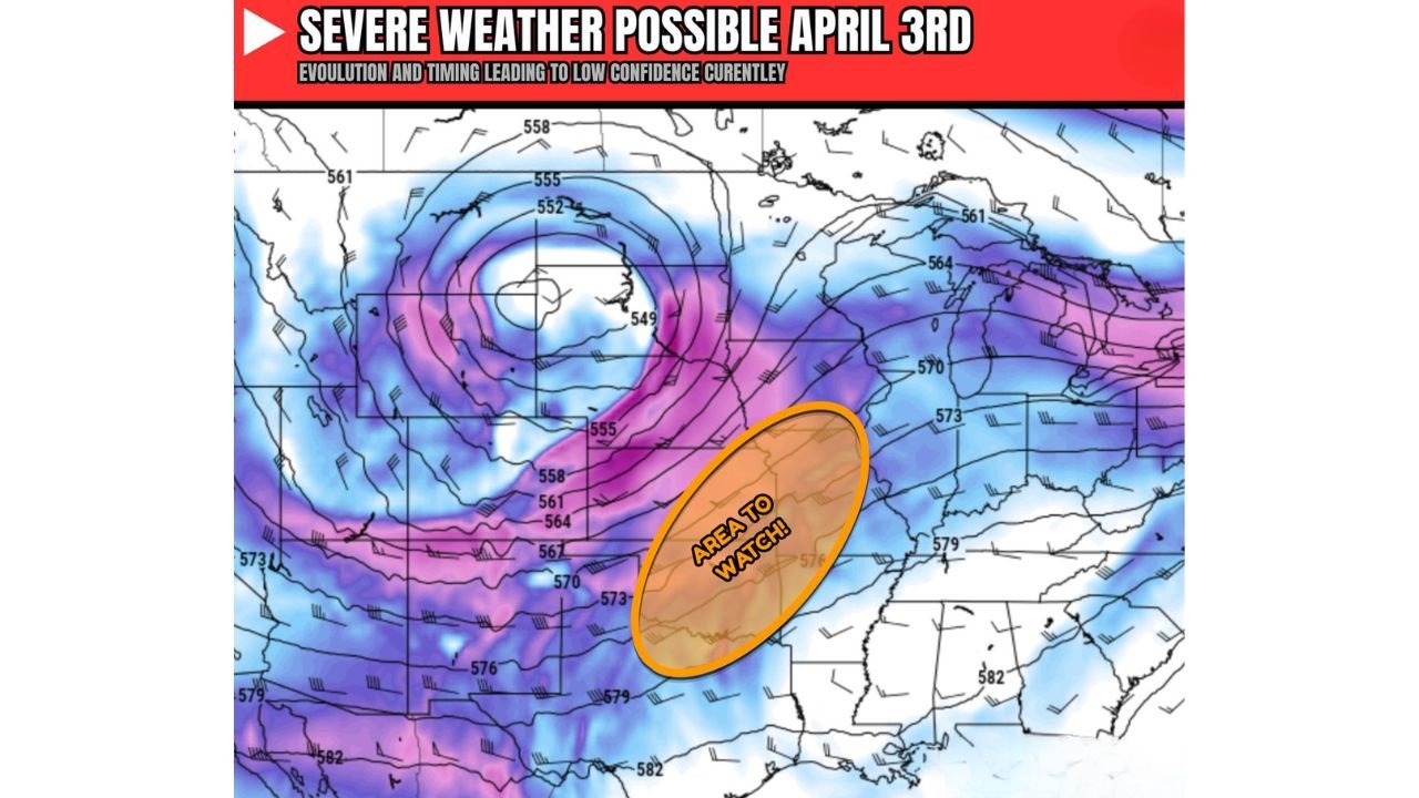
The Area to Watch: Kansas, Oklahoma and the Surrounding Corridor
The current atmospheric analysis is highlighting a broad watch area centered over Kansas and Oklahoma, extending into northern Texas and southwest Missouri. This is the zone where the shortwave energy, surface low development and Gulf moisture return are most likely to intersect on April 3rd.
The 500 mb upper-level pattern shown in the latest model data is displaying a deep, closed upper-level low positioned over the western United States, with a long trough axis extending southward into the southern Plains. The purple and magenta shading on the map indicates the area of strongest upper-level energy — and that energy is pointed directly at the Kansas-Oklahoma corridor as April 3rd approaches.
The orange highlighted watch zone on the map sits directly downstream of that upper-level energy axis, covering the area from central Kansas southward through Oklahoma — exactly where surface-based thunderstorm development would be expected once the shortwave arrives and surface boundaries become established.
What All Hazards in Play Actually Means for You
When meteorologists say all hazards are in play, it is not a phrase used casually. It means the atmospheric setup is capable of producing every category of severe weather simultaneously across the risk zone. For April 3rd, that means:
Tornadoes are a real threat. Supercell thunderstorms developing ahead of the shortwave in an environment with strong wind shear and sufficient low-level moisture have the potential to produce significant tornadoes. This is not a spin-up threat from a weak storm — this is a classic Plains tornado setup if the ingredients fully come together.
Large hail is likely with any supercell that fires in this environment. Baseball-sized or larger hail is possible in the strongest storms, particularly across central and western Kansas and the Oklahoma Panhandle where CAPE values and shear profiles will be most favorable.
Damaging straight-line winds will be the most widespread threat, especially as any organized convective line races northeast through the risk zone during the afternoon and evening hours on April 3rd.
Where the Uncertainty Still Lives
Here is the honest assessment of where this forecast stands right now. Considerable uncertainty remains in exactly how this trough evolves — specifically its placement and timing as it approaches the Plains on April 3rd. A trough that arrives slightly too early, too late or too far north or south can completely change which areas face the highest severe weather risk and which see little to nothing.
The growing model agreement on the shortwave ejection is an encouraging signal that this setup is becoming more real with each model run. But agreement on the existence of a setup and agreement on the precise details of that setup are two different things. The details will sharpen significantly over the next 48 to 72 hours.
April 3rd Severe Weather Confidence Table
| Parameter | Current Signal | Confidence | Key Uncertainty |
|---|---|---|---|
| Shortwave Ejection into Plains | 🔴 Growing Agreement | Moderate | Exact timing and placement |
| Surface Low Development | 🔴 Favorable | Moderate | Track and intensity |
| Tornado Threat | 🟠 All Hazards in Play | Low-Moderate | Moisture depth and shear |
| Large Hail Threat | 🔴 Likely with Supercells | Moderate | Storm mode evolution |
| Damaging Wind Threat | 🔴 Widespread | Moderate-High | Squall line timing |
| Overall Setup Confidence | 🟠 Growing But Not Locked | Low-Moderate | Evolving daily |
Where Each State Stands for April 3rd
🔴 Kansas — Wichita, Salina and the central Kansas corridor sit directly inside the primary watch area. If this setup comes together as currently indicated, Kansas faces the highest combined tornado, hail and wind threat of any state in the risk zone on April 3rd.
🔴 Oklahoma — Oklahoma City, Enid and the northern Oklahoma corridor fall within the highlighted watch area. Tornado-capable supercells are the primary concern for Oklahoma with this setup, particularly in the afternoon and early evening hours.
🟠 Missouri — Joplin through Springfield and Kansas City sit on the northeastern extension of the risk zone. As storms track northeast through the afternoon, Missouri faces damaging winds and large hail with isolated tornado potential.
🟠 Northern Texas — On the southern flank of the primary risk zone. Amarillo through the Texas Panhandle faces a hail and wind threat. Additional storm activity possible on April 4th as outflow boundaries become established across northern and central Texas.
🟡 Nebraska — Northern fringe of the watch area. Omaha and Lincoln could see the tail end of any squall line activity moving northeast out of the primary risk zone late April 3rd.
🟡 Iowa and Illinois — On the far northeastern edge of the pattern. Damaging wind potential late in the event as storms accelerate northeast.
What to Do Between Now and Friday
April 3rd is five days away. That is enough time to prepare but not enough time to be complacent. The most important thing you can do right now is make sure your weather alert notifications are active on every device in your household. The National Weather Service will issue watches and warnings as the event approaches — those alerts are your most critical tool.
Know your nearest shelter location. Know the difference between a Tornado Watch — the conditions are right, stay alert — and a Tornado Warning — a tornado has been confirmed or indicated, take shelter immediately. In a setup like this, the time between a watch and a warning can be very short.
Check back daily as model data continues to sharpen the April 3rd picture. The next 48 hours of model runs will be critical in determining exactly who faces the highest risk across the central Plains on Friday.
Data Sources: NOAA/NWS Storm Prediction Center | Upper-Level Atmospheric Analysis, April 3 2026 Pattern | Model Assessment current as of March 28, 2026
April 3rd Could Be One of the Most Significant Severe Weather Days Across Kansas and Oklahoma This Spring Season
The window to prepare is open right now and it will not stay open long. Stay informed at ChicagoMusicGuide.com — your source for daily severe weather updates, tornado outbreak tracking and storm coverage across Kansas, Oklahoma, Missouri and the entire United States.