Kansas and Oklahoma Are Now on a Collision Course With a Major Severe Weather Day Friday April 3 as Both Top Models Start Locking In on the Same Setup and a Broad Tornado Risk Area Is Expected From the Storm Prediction Center
WICHITA, KS — The forecast for Friday April 3rd just took a significant step forward — and the direction it stepped is one that residents across Kansas and Oklahoma need to take seriously right now. Model agreement on the April 3rd severe weather setup is slowly but clearly beginning to materialize, with both major global models now painting a strikingly similar picture of what the atmosphere looks like across the Central Plains on Friday. A broad 15% tornado contour from the Storm Prediction Center is expected to be issued later today — a milestone that officially puts April 3rd on the national severe weather radar as a significant threat day.
What Model Agreement Actually Means and Why It Matters Now
Earlier this week, the two primary forecast models were telling noticeably different stories about April 3rd. That disagreement is now narrowing — and in severe weather forecasting, the moment models start converging on the same solution is the moment the forecast becomes actionable.
When meteorologists track model agreement, they are watching whether independent modeling systems — each initialized with slightly different data and using different mathematical approaches — are arriving at the same conclusion about where and when atmospheric conditions will become most favorable for severe weather. Agreement between models increases confidence that a setup is real, not a modeling artifact.
As of the latest model runs, both the ECMWF and the GFS are now showing a consistent picture of Friday’s atmospheric setup across Kansas and Oklahoma — and what they are both showing is a classic Central Plains severe weather environment.
What the Surface Maps Are Showing for Friday April 3rd
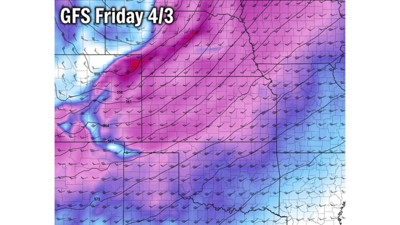
The surface analysis maps from both the ECMWF and GFS, valid for Friday April 3rd, show the same fundamental pattern: a strong moisture return pushing northward from the Gulf of Mexico into the Central Plains, overlapping with a deepening surface low pressure system tracking across the region.
Both maps display the sharp boundary between the warm, moist Gulf air — shown by the blue-green moisture shading pushing into Kansas and Oklahoma from the south and southeast — and the drier, cooler airmass to the west and northwest. This boundary is the dryline — the sharp moisture contrast boundary that is responsible for triggering some of the most explosive severe thunderstorm outbreaks in the history of Tornado Alley.
The GFS surface map is showing a somewhat deeper and better-organized surface low than the ECMWF for Friday — with pressure values dropping into the 998-1004 mb range across the Kansas-Oklahoma border region. A deeper surface low generates stronger wind shear and more robust moisture convergence along the dryline — both of which are favorable for tornado-producing supercell development.
The ECMWF surface map shows a slightly less aggressive surface low but agrees on the fundamental setup: moisture return into Kansas and Oklahoma, a sharp frontal boundary and dryline combination, and the surface pattern needed to support organized severe weather across the region.
What the Upper Level Maps Are Showing
The upper level maps — showing the wind flow pattern several miles above the surface — confirm what the surface maps are suggesting. Both models are showing a deep trough of low pressure positioned over the western United States on Friday, with strong jet stream energy rotating around its base and ejecting northeast into the Central Plains.
The GFS upper level map shows a particularly dramatic upper level pattern with intense jet stream winds indicated by the tight purple and magenta shading over Kansas and the surrounding region. The wind barbs on the map show strong and turning upper level flow — the kind of directional wind shear that organizes supercell thunderstorms and keeps them spinning long enough to produce significant tornadoes.
The ECMWF upper level map shows a similar but slightly less amplified version of the same pattern. The jet stream energy is present, the trough is positioned correctly, and the upper level support for severe weather development across Kansas and Oklahoma is clearly depicted.
Both models agree: the upper level pattern on Friday April 3rd supports explosive severe weather development across the Central Plains. The combination of Gulf moisture return at the surface and strong jet stream energy aloft is the textbook recipe for a significant severe weather outbreak in this region.
The SPC Outlook: What a 15% Tornado Contour Means
The Storm Prediction Center is expected to issue a Day 5 severe weather outlook including a broad 15% tornado probability contour for the April 3rd setup later today. For anyone unfamiliar with SPC tornado probability contours, here is what that number actually means in plain terms.
A 15% tornado probability from the SPC means that within 25 miles of any point inside the outlined area, there is a 15% or greater chance of at least one tornado occurring during the valid time period. At the Day 5 range — five days before the event — a 15% contour is a meaningful and significant signal. The SPC does not issue 15% tornado contours casually at extended ranges. When they appear at Day 5, they almost always verify with some level of tornado activity within the outlined area.
As the event approaches and confidence increases, these probability values can and often do increase into the 30%, 45% or higher range — particularly for setups that show the kind of model agreement now emerging for April 3rd.
Model Comparison Table: April 3rd Setup
| Parameter | ECMWF Solution | GFS Solution | Agreement Level |
|---|---|---|---|
| Surface Low Depth | Moderate — 1006-1010 mb | Deeper — 998-1004 mb | 🟠 Similar, GFS more aggressive |
| Moisture Return | Strong Gulf moisture into KS/OK | Strong Gulf moisture into KS/OK | 🔴 High Agreement |
| Upper Level Trough | Deep, well positioned | Deep, amplified | 🔴 High Agreement |
| Jet Stream Support | Strong over KS/OK | Very strong over KS/OK | 🔴 High Agreement |
| Dryline Position | Kansas-Oklahoma border | Kansas-Oklahoma border | 🔴 High Agreement |
| Overall Setup Confidence | Moderate-High | Moderate-High | 🔴 Converging |
Where Each State Stands for Friday April 3rd
🔴 Kansas — Wichita, Dodge City, Liberal, Salina — Sitting directly inside the expected SPC tornado probability contour. The surface low track, dryline position and upper level jet stream support all point toward central and western Kansas as the highest-risk zone for Friday’s event. All hazards are in play — tornadoes, large hail and damaging winds — with the tornado threat now the primary concern given the model agreement on the setup.
🔴 Oklahoma — Oklahoma City, Enid, Woodward, Ponca City — The northern Oklahoma corridor is directly in the path of the dryline and moisture return boundary on Friday. The OKC metro and the I-35 and I-40 corridors both fall within the expected tornado probability zone. This is a setup that Oklahoma residents have seen before — and one that demands respect.
🟠 Nebraska — South-central and southwestern counties — On the northern fringe of the expected risk area. Large hail and damaging winds are the primary threats for Nebraska communities near the Kansas border on Friday.
🟠 Missouri — Kansas City metro and western counties — As storms initiate across Kansas and track northeast, Kansas City faces a severe weather threat on Friday evening as the system moves through. Timing will depend on initiation location and storm motion.
🟡 Texas — Northern Panhandle — Southern extension of the risk area. Isolated severe weather possible across the Amarillo corridor if the dryline extends far enough south on Friday.
What Residents in Kansas and Oklahoma Should Be Doing Right Now
Friday is three days away. That is the preparation window — and it is the right time to start using it, not Wednesday night when the watches begin dropping.
Review your severe weather shelter plan today. If you live in a mobile home or manufactured housing anywhere in central Kansas or northern Oklahoma, identify a nearby sturdy building where you can take shelter on Friday. Mobile homes offer no protection from tornadoes regardless of their size or tie-down systems.
Confirm your wireless emergency alerts are enabled on every device in your household. As Friday approaches and watches are issued, those alerts are your fastest warning system — faster than television, faster than sirens and available even when you are away from home.
Watch for SPC outlook upgrades as the week progresses. The Day 5 15% contour expected today will likely be upgraded to higher probability values as April 3rd comes into the Day 3 and Day 2 outlook range — particularly if the GFS’s more aggressive surface low solution continues to hold in subsequent model runs.
Friday April 3rd Is Shaping Up to Be One of the Most Significant Severe Weather Days of the Spring Season Across Kansas and Oklahoma
The models are talking. The SPC is listening. Now it is time for residents across the Central Plains to start preparing. Stay informed at ChicagoMusicGuide.com — your source for daily model updates, SPC outlook tracking and severe weather coverage across Kansas, Oklahoma and the entire United States.