North Texas, Oklahoma and Southern Kansas Face a Potentially Significant Squall Line Wednesday Night April 1 With 60 to 70 mph Wind Gusts, Egg-Sized Hail and Quick-Hitting Tornadoes Threatening Oklahoma City, Wichita Falls and Enid
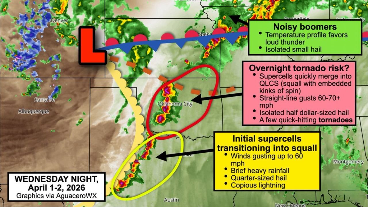
OKLAHOMA CITY, OK — Wednesday night is not going to be quiet across the southern Plains. A potentially significant squall line is expected to push through North Texas, Oklahoma and southern Kansas during the overnight hours of April 1 into early April 2 — and the detailed forecast for this event is now specific enough to name the cities at greatest risk, call the timing to the hour and identify exactly which threats will be highest at each stage of the storm’s evolution. If you are in Wichita Falls, Lawton, Oklahoma City, Enid or anywhere along the H.E. Bailey Turnpike corridor, Wednesday night demands your full attention before you go to sleep.
How This Storm Evolves: Hour by Hour
This is not a storm system that arrives all at once and moves through. It has a clear and well-defined evolution — from discrete supercells in the early evening to an organized squall line by late night — and each phase of that evolution carries its own specific threat profile.
6:00 to 7:00 PM — Storms Blossom Along the Dryline
The initial storm development is expected to begin around 6 or 7 PM Wednesday evening along a sharpening dryline. A dryline is the boundary between the warm, moist air sitting over the Plains and the hot, dry air pushing in from the west — and it is one of the most reliable storm triggers in the atmosphere across Oklahoma and North Texas during spring.
The storms that fire first along this boundary are expected to be supercells — the rotating, organized thunderstorms that are capable of producing the most dangerous weather. During this early supercell phase, the primary threats are large hail and damaging winds. Cells in southwest Oklahoma are specifically flagged for the potential to produce egg-sized hail — stones approximately 1.75 to 2 inches in diameter that cause serious damage to vehicles, roofs and anything left outdoors.
Egg-sized hail is large enough to shatter windshields, dent metal roofing and injure anyone caught outside without shelter. If you are in southwest Oklahoma Wednesday afternoon, get vehicles into covered parking before 6 PM.
7:00 to 9:00 PM — Supercells Transition and the Squall Line Builds
By approximately 9 PM, the individual supercell storms are expected to begin merging and consolidating into one or more organized squall lines or clusters. This transition from discrete supercells to an organized line is a critical phase of the storm’s evolution because it fundamentally changes the threat profile.
As the squall line builds and pushes eastward, the large hail threat begins to decrease — organized lines are less efficient at producing giant hail than discrete supercells. But what replaces the hail threat is, in many ways, more dangerous for the greatest number of people: straight-line wind gusts of 60 to 70 mph become the dominant threat as the squall line races east.
60 to 70 mph straight-line winds are capable of downing trees, collapsing fences, damaging roofs, flipping light trailers and causing widespread power outages across a broad corridor. Unlike a tornado, which affects a relatively narrow track, a squall line can produce these damaging wind gusts simultaneously across hundreds of miles of territory in a matter of minutes.
9:00 PM to 3:00 AM — The Overnight Danger Window
This is the most dangerous phase of Wednesday night’s event — and the one that requires the most serious preparation from anyone in the risk zone.
As the squall line pushes east and encounters greater low-level moisture across the Oklahoma City metro and surrounding region, a few quick-hitting spinup tornadoes become possible. These are not long-track, wedge tornadoes of the type associated with discrete supercells in classic outbreak setups. They are brief, rapidly forming tornadoes that can spin up along kinks or bowing segments within the squall line — often with very short warning lead times.
The OKC metro area is specifically called out as a location where spinup tornadoes may occur. For the millions of people living across Oklahoma City, Edmond, Moore, Norman and the surrounding communities — this is the overnight threat that cannot be dismissed even though it carries lower probability than a classic supercell tornado setup.
The overnight timing makes this threat particularly dangerous. Most people will be asleep when the squall line reaches the OKC metro area. Nighttime tornado warnings are statistically more deadly than daytime warnings for exactly this reason — warning reception is dramatically reduced when the population is indoors and asleep. Weather alerts must be active and audible on your phone before you go to sleep Wednesday night.
Storms are expected to gradually decrease in intensity during the predawn hours as they outrun the atmospheric boundaries that were fueling their development.
Specific Threats by Storm Phase
Initial Supercell Phase (6-9 PM):
- Southwest Oklahoma — Egg-sized hail up to 1.75-2 inches
- North Texas through Oklahoma — Wind gusts up to 60 mph
- H.E. Bailey Turnpike corridor — All threats in play during evening commute hours
- Copious lightning and brief heavy rainfall
Squall Line Phase (9 PM onward):
- Straight-line wind gusts of 60 to 70 mph — Primary widespread threat
- Quick-hitting spinup tornadoes — Particularly near OKC metro
- Isolated half dollar-sized hail — Possible in stronger line segments
- Loud thunder — Temperature profile specifically noted as favorable for loud thunder events
Wednesday Night Threat Timeline Table
| Time Window | Storm Mode | Primary Threats | Highest Risk Cities |
|---|---|---|---|
| 6 PM – 9 PM | Discrete Supercells | Egg hail, 60 mph winds, lightning | Altus, Lawton, Wichita Falls |
| 9 PM – Midnight | Squall Line Building | 60-70 mph winds, spinup tornadoes | OKC, Enid, Lawton |
| Midnight – 3 AM | Organized Squall Line | 60-70 mph winds, embedded tornadoes | OKC Metro, Wichita, Mulvane |
| Predawn | Weakening | Diminishing winds, residual lightning | Eastern Oklahoma, SE Kansas |
| Forecast Confidence | High for general timing | Moderate for exact locations | Moderate-High |
City-by-City Risk Assessment
🔴 Oklahoma City Metro — OKC, Edmond, Moore, Norman — The most critical overnight risk zone for Wednesday night. The squall line is specifically expected to find greater low-level moisture as it reaches the OKC corridor — the atmospheric ingredient that most commonly triggers spinup tornadoes within squall lines. This is the city to watch most closely from 9 PM onward. Residents across the metro should have weather alerts active and a shelter plan ready before the evening news ends.
🔴 Wichita Falls, TX — In the direct path of initial supercell development during the early evening hours. Large hail and damaging winds are the primary threats for the 6 to 9 PM window. The city sits near the southern end of the squall line’s expected track.
🔴 Lawton and Fort Sill, OK — Specifically named in the forecast for Wednesday night. Inside both the early supercell hail and wind threat and the later squall line wind and tornado threat as the system pushes east.
🔴 Enid, OK — Directly on the squall line’s expected track through the overnight hours. Damaging winds and spinup tornado potential are the primary concerns for the Enid area between approximately 9 PM and 1 AM.
🔴 H.E. Bailey Turnpike Corridor — This major southwestern Oklahoma travel corridor is specifically called out in the forecast. Anyone traveling this highway during Wednesday evening hours should monitor conditions very closely — the initial supercell phase is expected to be most active near this corridor during the 6 to 9 PM window.
🟠 Wichita and Mulvane, KS — The northern extent of the squall line’s expected track. These communities face the squall line wind and embedded tornado threat in the later overnight hours as the system pushes northeast out of Oklahoma.
🟠 Altus, OK — Inside the initial supercell threat zone for Wednesday evening. Egg-sized hail and 60 mph wind gusts are the primary concerns during the early storm phase.
What You Need to Do Before Wednesday Night
For southwest Oklahoma residents — Altus, Lawton, Wichita Falls: Vehicles in covered parking before 6 PM. Egg-sized hail causes severe and expensive damage. Do not wait until storms are showing on radar to move your vehicle.
For OKC metro residents: This is a go-to-sleep-with-your-phone-alerts-on event. The squall line arrives during the overnight hours. Set your phone to its loudest alert setting before you go to bed Wednesday night and place it where you can hear it clearly from your bedroom. The lead time on spinup tornadoes within squall lines is often measured in minutes — not the 10 to 15 minutes sometimes available with discrete supercell warnings.
For everyone in the risk zone: Know where your nearest shelter is. For those in mobile or manufactured homes across southwest Oklahoma, do not shelter in place during this event. Identify a nearby substantial building and have your plan to reach it ready before the evening begins.
Wednesday Night Is Just the Opening Act — Friday April 3rd Brings an Even More Significant Severe Weather Setup Across the Central Plains
The severe weather outbreak that begins Wednesday night continues building through the week. Stay informed at ChicagoMusicGuide.com — your source for hour-by-hour severe weather timing, squall line tracking and tornado alerts across Oklahoma, Texas, Kansas and the entire United States.