Kansas, Oklahoma, Missouri and Michigan Face a Four-Day Severe Weather Outbreak From Wednesday Through Saturday With Tornadoes, Large Hail and Damaging Winds Possible Each Day Across the Central United States
KANSAS CITY, MO — This is no longer a single-day severe weather event to watch. What is now taking shape across the central United States is a four-day, multi-system severe weather outbreak stretching from Wednesday through Saturday — and the corridor running from Oklahoma and Kansas northeastward through Missouri, Illinois, Indiana and into Michigan is going to be in the crosshairs repeatedly. All hazards are on the table for each individual day in this outbreak window — tornadoes, large hail and damaging winds — with no clean break between systems giving the affected region time to recover before the next round arrives.
The Four-Day Outbreak: How It Sets Up Day by Day
Wednesday — The Opening Round Across Kansas, Oklahoma, Missouri and Arkansas
Wednesday is where this outbreak begins — and it begins across the heart of Tornado Alley. The first system targets Kansas, Oklahoma, Missouri and Arkansas with a squall line expected to push through the region during the afternoon and overnight hours. Wednesday night’s setup across northern Texas and Oklahoma brings a particular overnight tornado threat as the squall line encounters increasing low-level moisture across the OKC metro and surrounding corridor.
This opening-day severe weather establishes the outflow boundaries and atmospheric conditioning that directly influences how the subsequent days play out.
Thursday — The Outbreak Expands Northeast Into Illinois, Indiana and Michigan
As Wednesday’s system tracks northeast and a new atmospheric trigger arrives, the severe weather zone expands significantly on Thursday. The risk area shifts toward Iowa, Illinois, Indiana, Missouri and southern Michigan — with the highest EHI values and strongest low-level wind shear concentrated across the northern portion of the risk zone. Thursday is the day that puts Chicago, Indianapolis and Detroit directly in the severe weather conversation.
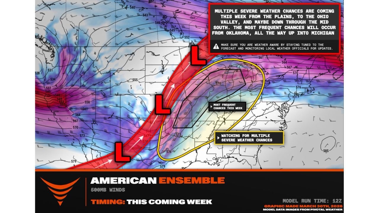
The American Ensemble data shows the most frequent severe weather chances of the entire week concentrated in the corridor running from Oklahoma northeastward all the way through Michigan — a nearly 1,000-mile swath of the country where residents will need to be weather-aware for multiple consecutive days.
Friday and Saturday — A New Trough Arrives and the Outbreak Continues
Just as Thursday’s system exits the region, a new trough arrives from the west on Friday — bringing a similar pattern and similar severe weather potential back to the central Plains and Midwest for a second round. The Friday-Saturday system essentially resets the severe weather clock for states that had already dealt with Wednesday and Thursday’s threats.
This second-system arrival is what elevates this event from a multi-day severe weather stretch to a full outbreak scenario — because it means the atmosphere does not have time to stabilize between rounds. Storm-produced outflow boundaries from Wednesday and Thursday remain in place to serve as triggers for Friday and Saturday’s storms, and the overall moisture and instability environment remains favorable through the weekend.
The Full Outbreak Corridor: Oklahoma to Michigan
The American Ensemble model map for this week’s outbreak clearly identifies two geographic zones of concern across the central United States.
The inner yellow oval — labeled “Most Frequent Chances This Week” — covers the core of the outbreak corridor running from Oklahoma and Kansas northeastward through Missouri, Illinois, Indiana and into Michigan. This is the zone that faces severe weather threats on the greatest number of days across the Wednesday through Saturday window. Residents inside this corridor should plan for at least two to three separate severe weather events before Saturday ends.
The outer yellow zone — labeled “Watching for Multiple Severe Weather Chances” — extends the potential outbreak footprint southward through Arkansas, Tennessee, Kentucky and the Ohio Valley as well as westward into Nebraska and the Texas Panhandle. These areas face fewer total severe weather days than the inner corridor but are clearly within the outbreak envelope for at least one to two of the four active days.
The three red “L” markers on the map — each representing a separate surface low pressure system tracking through the region — visually tell the story of why this outbreak spans four days. Three distinct storm systems arriving in sequence means three separate severe weather triggers for the same geographic corridor in less than 96 hours.
Four-Day Outbreak Summary Table
| Day | Primary Risk Zone | All Hazards | Tornado Potential | Confidence |
|---|---|---|---|---|
| Wednesday April 1 | KS, OK, MO, AR | 🔴 Yes | 🟠 Overnight threat — OKC area | Moderate-High |
| Thursday April 2 | IA, IL, IN, MI, MO | 🔴 Yes | 🟠 Northern risk zone highest | Moderate-High |
| Friday April 3 | KS, OK, NE, MO | 🔴 Yes | 🔴 Significant potential | Moderate-High |
| Saturday April 4 | IL, IN, OH, MI | 🔴 Yes | 🟠 Squall line spin-ups | Moderate |
| Overall Outbreak | OK through MI corridor | 🔴 All Hazards Each Day | 🔴 Tornadoes Possible Daily | 🔴 High |
State-by-State Outbreak Exposure
🔴 Oklahoma — Active on Wednesday and Friday with the highest tornado potential of any state in the outbreak. The OKC metro faces overnight severe weather Wednesday and returns to the risk zone Friday as the second trough arrives. Oklahoma is the most consistently impacted state across the full four-day window.
🔴 Kansas — Inside the severe weather risk zone on Wednesday, Thursday and Friday — three of the four outbreak days. Wichita, Topeka and the central Kansas corridor face repeated rounds of severe weather through the week. No clean break before Friday’s new trough arrives.
🔴 Missouri — Kansas City and St. Louis both face severe weather exposure on Wednesday through Friday. Missouri sits in the overlap zone between the opening-day southern Plains threat and the expanding Thursday Midwest threat. Three consecutive days of severe weather risk for Missouri communities.
🔴 Illinois — Chicago and the northern Illinois corridor are specifically called out in the outbreak data as part of the most frequent severe weather zone. Thursday is Illinois’s highest-risk day with the expanded northeast threat — but Friday also brings renewed severe weather potential as the second trough pushes through.
🔴 Michigan — Detroit, Lansing and the southern Lower Peninsula sit inside the “Most Frequent Chances” yellow oval. Thursday evening is Michigan’s primary severe weather window as storms track northeast out of Indiana and Illinois. Saturday brings a secondary threat as the Friday-Saturday system moves through.
🟠 Indiana — Indianapolis and the I-65 corridor face severe weather on Thursday and again on Saturday. Indiana sits in the direct path of the northeast-tracking storm systems on both days.
🟠 Iowa — Des Moines and Cedar Rapids are in the risk zone for Thursday’s expanded outbreak. Iowa sits on the northern edge of the most frequent severe weather corridor.
🟠 Arkansas and Tennessee — Inside the broader outer watching zone. Severe weather possible across both states particularly Wednesday and Thursday as the first system tracks through the mid-South.
🟠 Nebraska — Northern fringe of the Friday Plains setup. Omaha and Lincoln face severe weather potential as the second trough arrives Friday.
What Makes a Four-Day Outbreak More Dangerous Than a Single Event
A single severe weather day — even a significant one — allows communities to respond, recover and prepare for whatever comes next. A four-day outbreak removes that recovery time entirely.
Trees that were weakened or partially downed by Wednesday’s storms become hazards for Thursday’s winds. Soils already saturated from Wednesday’s rainfall produce faster runoff and more flash flooding with Thursday’s rain. Emergency management resources stretched thin by Wednesday’s tornado damage have less time to reposition before Friday’s threat arrives. Residents who stayed up late monitoring Wednesday’s overnight storms are more fatigued and less alert for Thursday’s afternoon threat.
This compounding effect is what makes multi-day outbreaks disproportionately dangerous compared to their individual-day components — and it is why preparing before Wednesday rather than reacting day by day is the most important thing any resident across this corridor can do right now.
What to Do Before Wednesday Arrives
Today and tomorrow are your preparation days. Once Wednesday’s storms begin firing, the four-day clock starts — and it does not pause between rounds.
Confirm your severe weather alerts are active on every device in your household right now. A tornado warning at 2 AM on a Wednesday night — the exact scenario possible for OKC metro residents — requires alerts that are loud enough to wake you from a sound sleep.
Know your shelter for each location where you spend time — home, workplace, school, gym. A four-day outbreak means multiple different times of day when severe weather could strike — not just the typical afternoon peak hours.
For mobile home residents across any state in the risk corridor — identify a nearby permanent structure before Wednesday morning. No mobile home offers adequate protection from tornadoes or 70 mph wind gusts regardless of its construction.
Wednesday Through Saturday Brings One of the Most Active Severe Weather Weeks of the Spring Season to the Central United States
Four days. Three separate storm systems. All hazards in play every day. Stay informed at ChicagoMusicGuide.com — your source for daily outbreak updates, tornado tracking and severe weather coverage across Oklahoma, Kansas, Missouri, Illinois, Indiana and Michigan throughout this entire multi-day event.