Central Illinois and Eastern Missouri Face Significant Tornado and Severe Storm Threat Thursday With Supercell Conditions Building Across the Springfield, Jacksonville and St. Louis Corridors
SPRINGFIELD, IL — The skies over central Illinois and eastern Missouri are about to get very dangerous — and the atmospheric data building ahead of Thursday’s storm system leaves little room for reassurance.
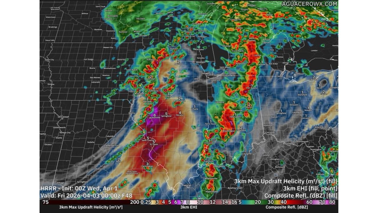
A severe weather outbreak is taking shape across the central United States, with conditions aligned to support rotating thunderstorms capable of producing significant tornadoes, destructive large hail, and damaging straight-line winds. The core of the highest-risk environment is locked onto a corridor stretching from Jacksonville and Springfield, Illinois southward through St. Charles and St. Louis, Missouri — a densely populated stretch where the ingredients for a violent weather event are stacking up fast.
Why This Setup Is Drawing Serious Attention
What makes Thursday’s threat stand out is not just one factor going in the wrong direction — it is every major ingredient pointing toward a high-end severe weather environment at the same time.
Latest model data shows CAPE (Convective Available Potential Energy) — the measure of raw fuel available for thunderstorm development, think of it as the explosive energy loaded into the atmosphere — sitting at 1,734 joules per kilogram at the surface. As Thursday afternoon heats up, that number is forecast to surge to 2,637 joules per kilogram. That is a significant jump, and it matters because stronger CAPE means updrafts inside storms become faster and more violent, giving rotating columns of air the energy they need to reach the ground as tornadoes.
Supporting that instability is an equally alarming wind shear profile:
- Surface-to-3km storm-relative helicity — the measure of how much wind rotates with altitude, which is what allows storms to spin — is modeled at 437 m²/s²
- Surface-to-1km helicity in the critical low-level layer measures 131 m²/s²
- Both values fall firmly within the range associated with tornadic supercell development
The Significant Tornado Parameter (STP), a composite index meteorologists use to gauge the overall threat of significant tornado production, is modeled at 3.8 for the primary risk zone. An STP value above 1.0 is considered elevated. At 3.8, the data is signaling the kind of environment historically associated with EF-2 or stronger tornadoes — storms with winds exceeding 111 mph capable of destroying well-built homes and sweeping vehicles off highways.
The Upper-Level Pattern That Raises the Stakes
Current analysis indicates that a powerful trough — a deep dip in the jet stream at around 18,000 feet — is driving the system into the region Thursday. The area of most concern is positioned within what meteorologists call the left-exit region of that trough, a zone where upper-level winds accelerate outward and act like a pressure valve, pulling storm updrafts upward and allowing them to grow taller, spin harder, and survive longer.
Storm track data suggests a triple-point boundary — where cold, warm, and moist air masses all intersect at the surface — may be positioned directly beneath this favorable upper-level zone. When surface boundaries and upper-level jet dynamics align like this, the probability of long-track supercells increases sharply.
The 3km Energy-Helicity Index, which combines instability and wind shear into a single supercell potential score, is modeled at 5 to 6 near the Jacksonville and Springfield corridor — an extreme reading that underscores how charged the environment will be Thursday.
Model and Data Summary
| Parameter | Modeled Value | What It Means |
|---|---|---|
| Surface CAPE | 1,734 J/kg | Strong atmospheric fuel for storms |
| Forecast CAPE (Peak) | 2,637 J/kg | Explosive updraft potential |
| SFC-3km Helicity | 437 m²/s² | Well within tornado-producing range |
| SFC-1km Helicity | 131 m²/s² | Low-level rotation support confirmed |
| Significant Tornado Parameter | 3.8 | Major tornado event threshold exceeded |
| 3km EHI (Springfield/Jacksonville) | 5 to 6 | Extreme supercell environment |
| 3km EHI (St. Louis/St. Charles) | 5 | High rotating storm potential |
| Upper-Level Jet Speed | 80 to 100+ knots | Strong ventilation for storm growth |
Where the Threat Is Greatest: State-by-State Breakdown
🔴 Illinois (Central) — Jacksonville, Springfield, Decatur, Peoria Corridor The highest-risk zone in this event. EHI values of 4 to 6 across this corridor represent an extreme supercell environment. Significant tornadoes, very large hail, and destructive winds are all in play Thursday afternoon and evening. Residents in these areas must have a shelter plan ready before storms arrive.
🔴 Missouri (Eastern) — St. Louis Metro and St. Charles Equally dangerous. EHI values near 5 extend into the St. Louis metropolitan area. Supercells moving out of Illinois into this region may still be organized and capable of producing significant tornadoes and damaging wind events. The high population density here makes preparedness critical.
🟠 Illinois (Northern Fringe) — Galesburg, Burlington, Davenport Border Area Elevated risk. EHI values of 2 to 4 indicate organized storm potential. Large hail and damaging winds are the primary threats, with isolated tornado development possible if supercells remain structured as they track northward.
🟠 Indiana (Western) — Vincennes and Evansville Vicinity Elevated risk. A secondary storm band pushes into western Indiana with EHI values of 1 to 2. Damaging wind gusts and large hail are expected with the most organized cells in this corridor.
🟡 Missouri (Southern) — Farmington and Surrounding Areas Marginal risk. The storm environment weakens south of the primary corridor, but isolated strong to severe thunderstorms remain possible Thursday evening.
🟡 Wisconsin and Iowa — Southern Fringe Marginal risk. The northern end of the squall line may produce gusty, potentially damaging winds as the system accelerates northward into Thursday night.
🟢 Michigan, Ohio, Kentucky Low risk. These states are outside the primary severe weather corridor for the Thursday event.
How Confident Is This Forecast
Forecast Confidence: Moderate to High. The large-scale atmospheric pattern is well-established and multiple high-resolution model runs are in strong agreement that a significant severe weather environment will exist across central Illinois and eastern Missouri on Thursday.
The primary uncertainty involves the timing of early-day convection — if thunderstorms fire prematurely before peak afternoon heating, they could destabilize the environment and reduce the threat from the organized supercell phase later in the day. The exact position of the upper-level shortwave could also shift the bullseye zone by 50 to 100 miles.
What is not uncertain is the ceiling on this event. If the atmosphere performs as modeled, long-track supercells capable of producing EF-2 or stronger tornadoes are possible across the Springfield and St. Louis corridors. All residents across central and southern Illinois, eastern Missouri, and western Indiana should monitor conditions closely, identify their nearest shelter before Thursday afternoon, and keep a weather radio or alert-capable device accessible throughout the day.
More severe storm and tornado coverage is always on the horizon. Stay informed at ChicagoMusicGuide.com — your source for supercell and tornado outbreak tracking across the Midwest and the entire United States.