Texas and the Southern Plains Are on Track for a Wetter and Cooler Summer Than Recent Years as Seasonal Rainfall Outlooks Show Above-Normal Precipitation Through August 2026
DALLAS, TX — After years of punishing heat and drought cycles, the atmospheric signals now lining up for Texas and the Southern Plains are painting a picture that forecasters rarely get to describe for this region: a summer that may actually bring meaningful, sustained rainfall and temperatures that stay below the brutal extremes residents have endured in recent seasons.
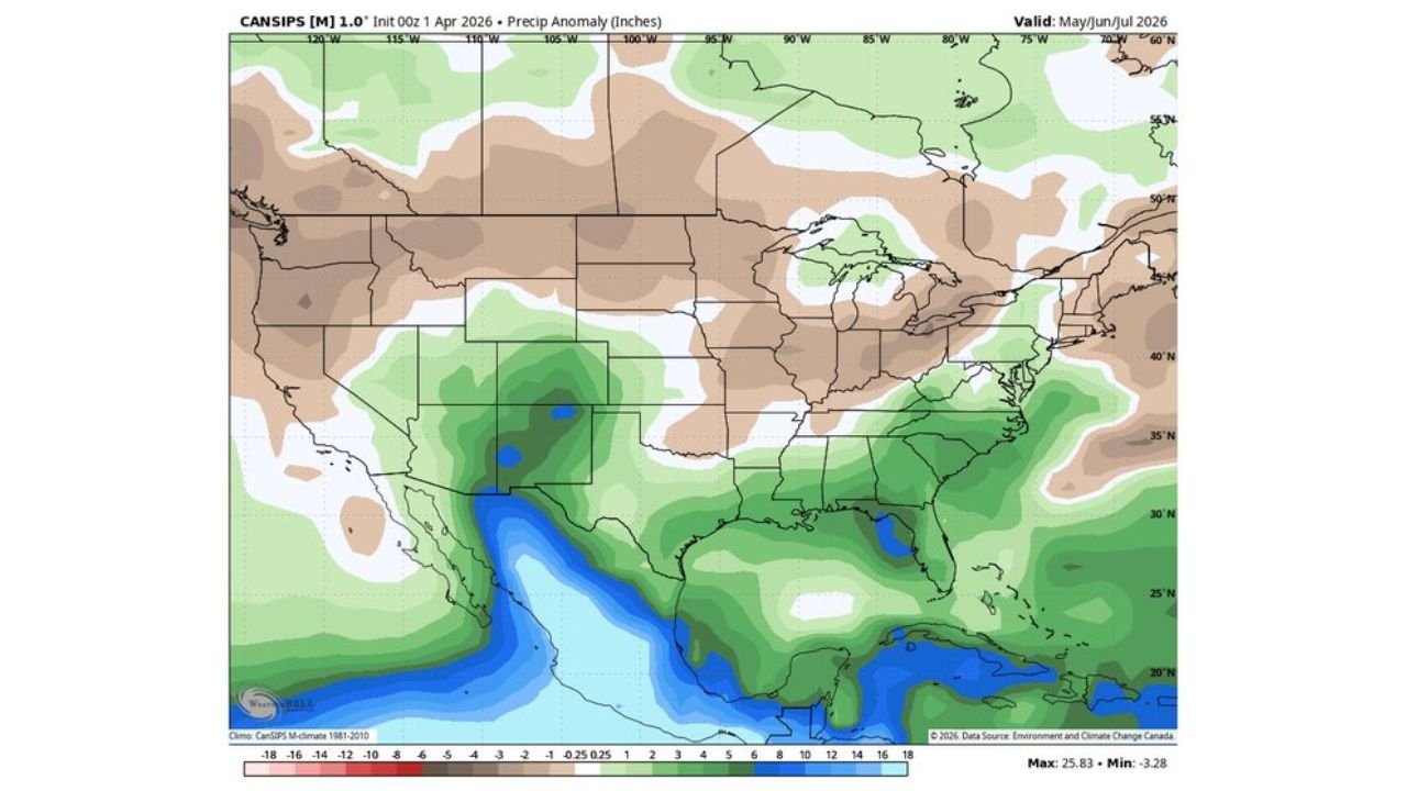
The latest long-range seasonal precipitation outlook, initialized April 1, 2026, shows a consistent and persistent pattern of above-normal rainfall across Texas, Oklahoma, and neighboring southern states stretching from the current spring season all the way through August 2026. If this pattern holds, it would mark a significant and welcome departure from the heat-dominated, drought-stressed summers that have defined the region in recent years.
What the Seasonal Data Is Actually Showing
Long-range seasonal outlooks measure precipitation anomaly — the difference in inches between what is expected to fall and what would be considered climatologically normal for a given period. Positive green values mean more rain than average is projected. Negative brown values signal drier-than-normal conditions are expected.
Across three consecutive seasonal periods analyzed — spring, early summer, and peak summer — the signal for Texas and the Southern Plains remains consistently and significantly in the green.
Spring Into Early Summer: March Through May 2026
Current analysis indicates Texas is already positioned inside a +2 to +6 inch above-normal precipitation anomaly zone for the March through May period. Oklahoma and Kansas show similar above-normal signals in the +1 to +4 inch range. Louisiana and Arkansas also fall within the above-normal corridor during this period.
The moisture signal intensifies south of the border into the Gulf of Mexico, with that enhanced moisture acting as a conveyor belt feeding the southern states with more frequent and heavier rainfall opportunities than climatology would typically deliver during spring.
Late Spring Into Early Summer: May Through July 2026
The above-normal rainfall signal not only holds through the May to July period — it strengthens across Texas. Latest model data shows precipitation anomalies of +4 to +10 inches above normal across central and west Texas during this window, with portions of the state potentially seeing some of the most significant above-normal rainfall totals in the entire outlook period.
Oklahoma and Arkansas maintain a +2 to +4 inch above-normal signal. The Southeast — including Florida, Georgia, and the Carolinas — also shows above-normal precipitation during this period, suggesting the wetter pattern is part of a broader atmospheric reorganization across the southern tier of the United States.
Peak Summer: June Through August 2026
Even as summer reaches its most intense phase, the data holds. The June through August outlook continues to show Texas and the Southern Plains in +2 to +6 inch above-normal territory. Oklahoma and portions of Missouri and Arkansas remain in the green. Coastal Southeast states including the Gulf Coast corridor through Louisiana, Mississippi, Alabama, and Florida stay above normal through the peak summer window.
This is the most critical finding in the entire three-period outlook: the above-normal signal does not fade as summer intensifies. It persists.
Seasonal Outlook Comparison: Three-Period Summary
| Period | Texas Anomaly | Oklahoma | Southern Plains | Northern Plains |
|---|---|---|---|---|
| Mar/Apr/May 2026 | +2 to +6 inches | +1 to +4 inches | Above Normal | Near Normal |
| May/Jun/Jul 2026 | +4 to +10 inches | +2 to +4 inches | Above Normal | Below Normal |
| Jun/Jul/Aug 2026 | +2 to +6 inches | +1 to +3 inches | Above Normal | Below Normal |
State-by-State Seasonal Outlook
🔵 Texas — The standout story of this entire outlook. All three seasonal periods show persistent and significant above-normal precipitation. Central and west Texas in particular are projected to see the largest positive anomalies, with the May through July window showing potential anomalies of +4 to +10 inches above normal. A wetter and cooler summer than recent years is the projected outcome if this pattern holds.
🟢 Oklahoma — Consistently above-normal rainfall signals across all three outlook periods. The +1 to +4 inch anomaly range holds through spring and early summer, with the signal persisting but moderating slightly into peak summer. This is a meaningful improvement over drought-prone recent summers.
🟢 Arkansas and Louisiana — Both states fall inside the above-normal corridor through spring and early summer. The Gulf Coast moisture feed sustains the wetter-than-normal signal through much of the outlook period.
🟢 Florida, Georgia and the Carolinas — The Southeast shows above-normal precipitation through the May to July and June to August windows, suggesting the enhanced moisture pattern extends well across the southern tier of the eastern United States.
🟡 Kansas and Missouri — Near-normal to slightly above-normal signals through spring, with the anomaly becoming more marginal by peak summer. These states are on the edge of the primary enhanced moisture corridor.
🟠 Northern Plains (North Dakota, South Dakota, Montana, Wyoming) — The outlook turns drier-than-normal across the Northern Plains and Rockies by the May through July and June through August periods. Brown anomaly values of -2 to -6 inches signal a below-normal precipitation pattern that could stress agriculture and increase wildfire risk heading into peak summer across the northern tier.
🔴 Pacific Northwest (Washington, Oregon, Northern California) — The most persistently dry signal in the entire outlook. All three periods show -6 to -18 inch below-normal anomalies across the Pacific Northwest, representing a significant and sustained dryness signal that could have serious wildfire and water supply implications through summer 2026.
How Confident Is This Outlook
Forecast Confidence: Low to Moderate. It is important to understand what seasonal outlooks are and are not. These are probabilistic projections based on large-scale atmospheric patterns — they do not predict specific storm events or guarantee rainfall on any given day. They represent the most likely departure from normal conditions over a multi-month period.
The consistent persistence of the above-normal signal across Texas and the Southern Plains through all three consecutive seasonal periods is noteworthy and adds confidence to the general direction of the outlook. When a signal appears in the same region across multiple independent seasonal windows, forecasters treat it as a meaningful signal rather than noise. However, seasonal outlooks at the three-to-six month range carry inherent uncertainty, and conditions can and do evolve as the season progresses.
What can be said with reasonable confidence is that the large-scale atmospheric pattern currently initialized is oriented favorably for Texas and the Southern Plains to experience a wetter and potentially cooler summer than the recent drought-dominated years — a meaningful shift that residents, farmers, and water resource managers across the region will be watching closely.
More long-range weather pattern coverage is always on the horizon. Stay informed at ChicagoMusicGuide.com — your source for seasonal outlooks and climate trend analysis across Texas, the Southern Plains, and the entire United States.