Western Oklahoma, Southern Kansas and Northwest Texas Face Enhanced Risk of Gorilla Hail and Evening Tornadoes as Supercells Target Wichita Falls, Oklahoma City and Wichita After 4 PM Wednesday
OKLAHOMA CITY, OK — The national severe weather outlook just got more serious. The Storm Prediction Center has officially upgraded western Oklahoma, southern Kansas, and northwest Texas to an Enhanced Risk — Level 3 on the five-tier national scale — with the primary driver being an extreme hail threat that forecasters are describing as gorilla hail, an informal term used when hailstones are expected to reach truly dangerous, destructive sizes well beyond what most people have ever experienced.
The upgrade is not just about hail. As the afternoon transitions to evening, the atmospheric setup shifts gears — and the tornado threat is expected to intensify sharply during the evening hours as low-level wind shear surges across the region.
Why the Upgrade Happened and What Changed
Current analysis indicates a dry line — the boundary between dry desert air pushing east from the Rockies and deep Gulf moisture streaming northward — is the ignition point for tomorrow’s storm development. Supercell thunderstorms are forecast to fire off this boundary after 4 PM across the Enhanced Risk corridor, with the most dangerous phase of the event arriving during the early evening hours.
The gorilla hail threat is what triggered the SPC upgrade. This term describes hailstones of exceptional size — stones large enough to cause catastrophic damage to vehicles, rooftops, agricultural crops, and anything left outdoors. Hail of this caliber does not just dent cars. It punches through windshields, destroys solar panels, and can cause serious injury to anyone caught outside without immediate shelter.
Beyond the hail, storm track data indicates that low-level wind shear — the change in wind speed and direction in the lowest one to two miles of the atmosphere, which is the key ingredient for tornado formation — is forecast to ramp up sharply during the evening hours. This is the critical timing detail in tomorrow’s setup. Supercells that develop off the dry line after 4 PM will be moving into an increasingly favorable environment for rotation as the sun sets, meaning the tornado threat grows as the evening progresses rather than diminishing.
Any storm that gains access to a clean, uncontaminated environment — meaning it does not run into the outflow of a neighboring storm — will have the full atmospheric toolkit available to produce a significant tornado.
Risk Zone Breakdown
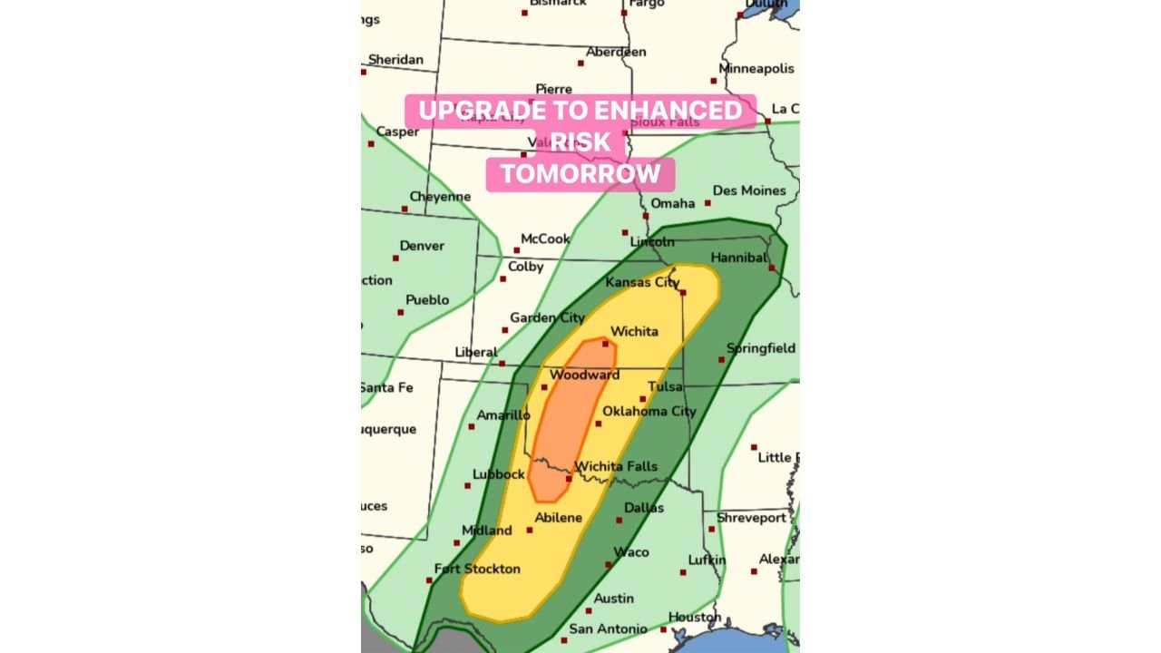
The upgraded outlook covers a broad corridor across three states, organized into four distinct risk tiers:
Enhanced Risk (Level 3) — The Gorilla Hail and Evening Tornado Core The Enhanced zone is centered over western Oklahoma including the Woodward corridor, extending southward through Wichita Falls, Texas and into the northwest Texas region near the Abilene fringe. This is where the largest hail and the highest tornado probability converge during the evening hours. Storms firing off the dry line will be most organized and most dangerous within this zone.
Slight Risk (Level 2) — Widespread Severe Threat The Slight Risk zone expands the threat into a broad corridor covering southern Kansas including Wichita, through Oklahoma City and central Oklahoma, and southward through north and central Texas including the Dallas-Fort Worth metro, Waco, and the northern Austin fringe. Large hail, damaging winds, and tornadoes are all possible across this entire zone.
Marginal Risk (Level 1) — Isolated Severe Possible The Marginal zone reaches Kansas City and the Nebraska fringe to the north, covers all of Oklahoma, extends through Texas to San Antonio and Houston, and pushes into Missouri and Arkansas to the east. Isolated severe thunderstorms are possible but widespread organized severe weather is not expected across the marginal zone.
Severe Weather Data Summary
| Threat | Zone | Key Areas | Timing |
|---|---|---|---|
| Gorilla Hail (Primary Driver) | Enhanced Core | Western OK, NW Texas, Wichita Falls | After 4 PM |
| Tornado (Escalating) | Enhanced and Slight | Western OK through Southern KS | Evening hours |
| Damaging Winds | Enhanced and Slight | OK City, Wichita, DFW corridor | 4 PM to midnight |
| Large Hail | Slight Risk zone | OKC, Wichita, Dallas-Fort Worth | 4 PM onward |
| Isolated Severe | Marginal zone | KC, San Antonio, Houston, Arkansas | Evening |
| Storm Initiation | Dry Line | Western Oklahoma/NW Texas | After 4 PM |
| Wind Shear Peak | Low-Level | Full Enhanced zone | Evening “magic hour” |
State-by-State Risk Assessment
🔴 Oklahoma (Western, Including Woodward Corridor) — Highest risk. The Enhanced zone bullseye sits directly over western Oklahoma. Gorilla hail, significant tornadoes, and damaging winds are all in play beginning after 4 PM and escalating through the evening. Supercells firing off the dry line here will have access to the most dangerous atmospheric environment in tomorrow’s setup.
🔴 Texas (Northwest, Including Wichita Falls and Abilene Fringe) — Highest risk. The Enhanced zone extends southward into northwest Texas, placing Wichita Falls and the surrounding region inside the core gorilla hail and evening tornado corridor. Residents here should be sheltered and alert before 4 PM.
🟠 Kansas (Southern, Including Wichita and Garden City) — Elevated risk. Southern Kansas falls inside the Slight Risk zone, with Wichita positioned within the broader enhanced corridor. Large hail, damaging winds, and tornadoes are possible as storms push northward into the evening.
🟠 Oklahoma (Central, Including Oklahoma City Metro) — Elevated risk. The OKC metro sits inside the Slight Risk zone. While the most intense Enhanced-level activity is focused to the west, organized supercells tracking through central Oklahoma can remain dangerous. Large hail and tornado potential persist through the evening.
🟠 Texas (North and Central, Including Dallas-Fort Worth and Waco) — Elevated risk. The Dallas-Fort Worth metroplex and the Waco corridor fall inside the Slight Risk zone. Large hail and damaging winds are the primary threats here, with an isolated tornado possible if supercells maintain structure as they track southeast.
🟡 Kansas (Central), Missouri (Western), Arkansas (Northwest) — Marginal risk. The Kansas City area and western Missouri fall inside the outer Marginal zone. Isolated severe thunderstorms are possible, primarily through the late evening hours as the storm system tracks northeast.
🟡 Texas (Central to Southern, Including San Antonio and Houston) — Marginal risk. Both the San Antonio and Houston metro areas fall inside the Marginal zone. The severe weather environment weakens considerably across southern Texas, but strong storms with damaging winds and hail remain possible during the overnight hours.
🟢 Nebraska, Iowa, Colorado, New Mexico — General thunderstorm potential only. These areas fall in the outermost light green zone on the outlook. Organized severe weather is not expected, though isolated strong storms are possible.
Forecast Confidence
Forecast Confidence: High for the Enhanced Risk Core. The SPC upgrade to Enhanced status signals that forecasters have reached a high level of certainty that significant severe weather — led by gorilla hail and an escalating evening tornado threat — will impact western Oklahoma, southern Kansas, and northwest Texas tomorrow. The dry line initiation timing after 4 PM is well-established across multiple model runs.
The most critical uncertainty in this setup is how cleanly individual supercells can stay separated from each other during the early evening hours. Storms that remain discrete — meaning they do not interfere with neighboring storm outflow — will have the best chance of producing significant, long-track tornadoes during the evening window when low-level wind shear is at its peak. If storms cluster together quickly into a line, the primary hazard shifts toward widespread damaging winds rather than tornadoes, but the gorilla hail threat remains regardless of storm mode.
All residents across the Enhanced and Slight Risk zones should plan to be sheltered before 4 PM, keep weather alerts active through midnight, and never attempt to seek shelter in a vehicle if a tornado warning is issued for their location.
More severe weather upgrades and storm coverage are always on the horizon. Stay informed at ChicagoMusicGuide.com — your source for supercell, hail, and tornado outbreak tracking across Oklahoma, Kansas, Texas, and the entire United States.