North Dakota and Minnesota Face Intensifying Snowstorm With Over 10 Inches Expected From Bismarck to Grand Forks Into Saturday Morning
NORTH DAKOTA, MINNESOTA — A powerful late-season winter system is set to deliver significant snowfall across the Northern Plains, with the heaviest accumulation expected from central North Dakota into eastern regions near Minnesota between Friday morning and early Saturday. Forecast data shows snow totals exceeding 10 inches in some areas, creating potentially dangerous travel conditions and widespread disruptions.
Heavy Snowfall Corridor Targets Central and Eastern North Dakota
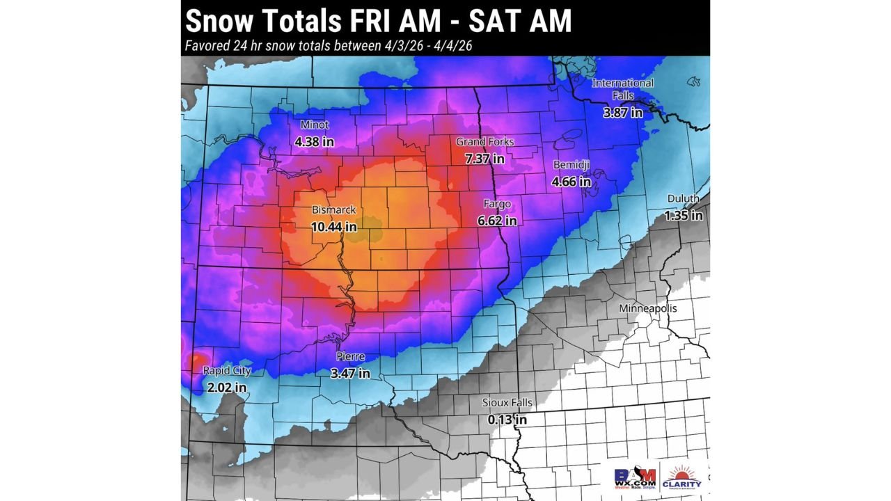
Forecast projections indicate that Bismarck, North Dakota could see the highest accumulation, with totals reaching approximately 10.44 inches, making it the core of this developing storm system. Surrounding regions are also expected to receive substantial snowfall, including Grand Forks at 7.37 inches and Fargo at 6.62 inches, highlighting a broad and intense snow band stretching across the state.
Further west, areas like Minot are expected to receive around 4.38 inches, while southern locations such as Pierre, South Dakota, could see totals near 3.47 inches. Even lighter but still impactful snowfall is expected in places like Rapid City, with around 2.02 inches, showing how widespread the system is across the Northern Plains.
The system’s structure suggests a well-organized snow band, with the most intense accumulation focused in a central corridor where moisture and cold air align perfectly. This setup often leads to prolonged snowfall and reduced visibility over several hours.
Minnesota Sees Moderate Snow With Sharper Drop-Off Toward the South
As the storm pushes eastward, Minnesota will also experience notable snowfall, particularly in northern areas. Bemidji is expected to receive around 4.66 inches, while International Falls could see approximately 3.87 inches, reinforcing the northern tier as a key impact zone.
However, snowfall totals begin to drop significantly moving south. For example, Duluth is projected to receive only around 1.35 inches, while areas like Minneapolis may see minimal or no accumulation as the southern edge of the system weakens.
One of the most striking contrasts appears near Sioux Falls, South Dakota, where totals are expected to be as low as 0.13 inches, illustrating a sharp cutoff in snowfall intensity. This gradient suggests that even small shifts in the storm track could dramatically change outcomes for cities near the boundary zone.
Timing and Travel Impacts Through Saturday Morning
The storm is expected to develop Friday morning and continue through early Saturday, with the heaviest snowfall likely occurring during peak daytime and evening hours. This timing raises concerns for both commuters and long-distance travelers, especially along major routes in North Dakota and northern Minnesota.
Heavy snowfall rates combined with gusty winds may lead to reduced visibility and localized blowing snow, increasing the risk of hazardous road conditions. Areas near Bismarck, Fargo, and Grand Forks should prepare for the most significant disruptions, including possible delays, closures, and difficult driving conditions.
Residents are advised to monitor updates closely as snow bands can shift, potentially altering accumulation totals in a short period. Even regions currently forecast for moderate snow could see higher totals if the system intensifies or shifts slightly.
What This Storm Means for the Northern Plains Region
This event highlights a persistent winter pattern across the Northern Plains, where systems continue to bring impactful snow well into the season. The projected totals—especially the double-digit snowfall near Bismarck—suggest this could be one of the more significant late-season storms for the region.
The contrast between heavy snow in North Dakota and minimal accumulation further south underscores how temperature gradients and storm positioning play a critical role in determining impacts. For communities in the heaviest band, preparation is essential, including limiting travel, securing supplies, and staying informed.
According to the forecast model used in this analysis, snowfall distribution is highly concentrated, reinforcing the need for localized awareness rather than broad regional assumptions.
As this winter storm continues to develop across North Dakota and Minnesota, staying updated on the latest forecasts will be critical for safety and planning. For more detailed weather updates, regional insights, and ongoing coverage of major events impacting communities, visit ChicagoMusicGuide.com.