Carolinas and Southeast Face Growing Dry Spell Risk While Midwest Sees Near Normal Rainfall in 14 Day Outlook Including Chicago and St Louis
UNITED STATES — A newly released 14-day precipitation outlook is raising concerns across the Carolinas and the broader Southeast, where below-normal rainfall is expected to dominate through mid-April. Meanwhile, regions across the Midwest, including Chicago and St. Louis, are forecast to experience closer to normal precipitation levels, highlighting a sharp divide in weather patterns across the country.
Carolinas and Southeast Enter Critical Dry Pattern During Peak Spring Season
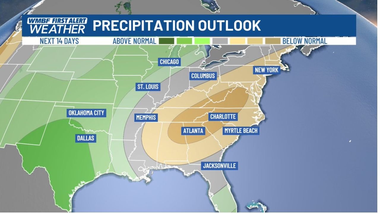
Forecast data shows a large area of below-normal rainfall stretching across North Carolina, South Carolina, Georgia, and parts of the Southeast, with the most pronounced dryness centered near Charlotte, Myrtle Beach, and Atlanta. This region is already entering a time of year when rainfall is typically limited, making the current outlook especially concerning.
April is historically one of the driest months in the Carolinas, and the projected lack of precipitation could accelerate dry soil conditions, increased fire weather risk, and rising water demand as spring activities ramp up. With gardening season beginning and temperatures gradually warming, water usage is expected to increase, further stressing local resources.
The extended nature of this dry outlook suggests that relief may not arrive quickly, increasing the potential for longer-term impacts if rainfall deficits continue to build over the coming weeks.
Midwest Including Chicago and St Louis Expected to See More Balanced Conditions
In contrast, the Midwest region, including cities like Chicago, St. Louis, and Columbus, is forecast to remain in a near-normal precipitation zone. This means rainfall totals over the next two weeks are expected to align more closely with seasonal averages, avoiding both excessive wetness and significant dryness.
This balanced pattern could benefit agricultural areas across Illinois, Missouri, and surrounding states, where stable moisture levels are important for early planting and soil preparation. While occasional storm systems may pass through, no prolonged dry or overly wet pattern is currently indicated for this region.
The positioning of this near-normal zone also acts as a transition area between the wetter Plains to the west and the drier Southeast to the east, further emphasizing the sharp gradient in precipitation across the United States.
Southern Plains Continue to Benefit From Above Normal Rainfall
To the west of the Midwest, parts of the Southern Plains, including Texas, Oklahoma, and areas near Dallas and Oklahoma City, are expected to receive above-normal rainfall. This is indicated by the green shading in the outlook, suggesting frequent storm activity and higher moisture availability.
This wetter pattern could help offset earlier dry conditions in some areas, though it may also bring localized flooding concerns if rainfall becomes excessive. The contrast between this region and the dry Southeast underscores the uneven distribution of precipitation across the country.
Why This Pattern Matters Heading Into Mid-April
The developing pattern reflects a broader atmospheric setup where storm systems are tracking more frequently across the central United States, leaving the Southeast under a relative rain shadow. This type of configuration often leads to prolonged dry periods in the Carolinas and surrounding areas, especially during transitional seasons like spring.
For the Southeast, the concern is not just short-term dryness but the potential for compounding effects, including increased wildfire risk and stress on water systems. Meanwhile, the Midwest’s more stable conditions provide a temporary buffer against extreme weather impacts.
As this 14-day outlook continues to evolve, regional differences in rainfall will play a critical role in shaping local conditions. For ongoing weather updates, regional forecasts, and detailed coverage of developing patterns across the United States, visit ChicagoMusicGuide.com.