Virginia, Maryland and Washington DC Stuck in Sudden Spring Chill as Cold Air Wedge Drops Temperatures 30 Degrees While Nearby Areas Stay Warm
WASHINGTON DC, VIRGINIA, MARYLAND, DELAWARE — A classic cold air wedge pattern has taken hold across the Mid-Atlantic, locking in unusually cool temperatures across Washington DC, northern Virginia, and Maryland, while nearby regions just to the south and west experience much warmer spring conditions. The result is a sharp temperature divide of more than 30 degrees across relatively short distances.
Cold Air Wedge Keeps Temperatures Stuck in the 50s Across DC Region
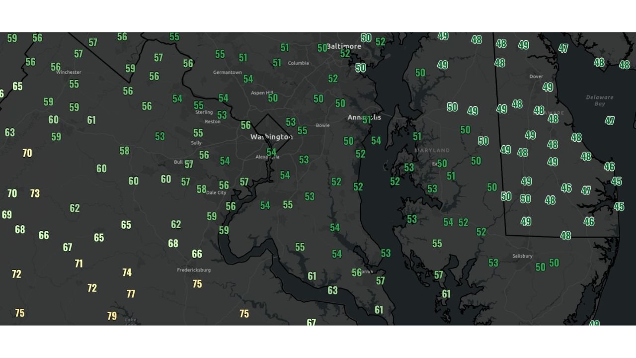
Across Washington DC, Arlington, Alexandria, and much of Maryland, temperatures have remained stuck in the low to mid-50s throughout the day, far below typical early April conditions. This persistent chill is being driven by a cool air mass trapped north of a stalled front, preventing warmer air from moving into the region.
Locations across Baltimore and surrounding areas are also experiencing similar conditions, with widespread readings in the 50 to 54 degree range. The steady inflow of cool air from the north and northeast has reinforced this pattern, making it difficult for temperatures to rise despite daytime heating.
This setup is commonly referred to as a “cold air wedge”, where dense, cool air becomes entrenched at the surface, often lasting for extended periods until the pattern breaks.
Warm Air Just Miles Away Highlights Dramatic Temperature Contrast
While the DC metro area remains cool, conditions change dramatically just to the south and west. Areas near Fredericksburg and Charlottesville in Virginia are seeing temperatures climb into the mid to upper 70s, creating a stark contrast over a relatively small geographic distance.
This temperature gradient highlights the strength of the stalled front, which is acting as a boundary separating cool, stable air to the north from warm, spring-like conditions to the south.
Even more noticeable differences are being observed farther east, where parts of Delaware are reporting temperatures in the 40s, influenced by cool air flowing in from the Atlantic Ocean. This reinforces the wedge effect, keeping coastal areas even cooler than inland regions.
Stalled Front Across Virginia and Delmarva Drives the Pattern
The key feature behind this setup is a stalled frontal boundary draped across central Virginia and the southern Delmarva region. North of this boundary, cool air is locked in place, while south of it, warmer air continues to dominate.
This type of pattern is well-known in the Mid-Atlantic and can lead to persistent cloudy, cool conditions that are difficult to break without a significant shift in the weather system.
The presence of the front also means that small changes in its position could lead to rapid temperature swings, especially in areas located near the boundary line.
Warmer Conditions Expected to Return as Front Lifts North
Relief from the cool conditions is expected as the stalled front begins to retreat northward over the next 24 hours, allowing warmer air to gradually return to the region.
As this shift occurs, areas currently experiencing temperatures in the 50s could quickly warm into the 70s, bringing a return to more typical spring weather across Washington DC, Virginia, and Maryland.
However, until that transition takes place, the cold air wedge will continue to dominate, keeping conditions cooler and more stable than surrounding regions.
What This Means for Residents Across the Mid-Atlantic
For residents across Washington DC, Maryland, Virginia, and Delaware, this pattern highlights how quickly conditions can change during the spring season. The presence of the wedge means that forecast temperatures can vary significantly depending on location, even within the same region.
Those in cooler zones should expect persistent cloud cover and chilly conditions, while areas south of the front will continue to experience warmer, more typical spring temperatures.
As this temperature divide continues to evolve across the Mid-Atlantic, staying updated on shifting conditions will be essential. For ongoing weather coverage, regional updates, and forecast insights, visit ChicagoMusicGuide.com.