Indiana and Southwestern Michigan Face Increasing Tornado Risk This Afternoon as Warm Front and Wind Shear Align Near South Bend and Benton Harbor
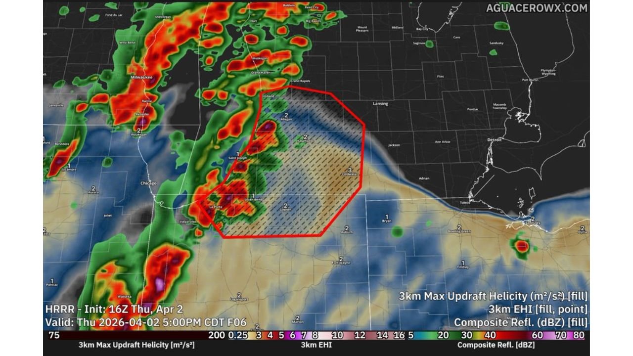
INDIANA, MICHIGAN — A developing severe weather setup is drawing attention to northern Indiana and southwestern Michigan, where conditions this afternoon are becoming increasingly favorable for tornado development and damaging winds. While the broader severe threat spans parts of Iowa, Missouri, Illinois, and Wisconsin, this region near South Bend, Benton Harbor, and the Lake Michigan shoreline is emerging as a secondary but potentially impactful zone.
Warm Front Positioning Creates Focused Risk Zone Near Indiana Michigan Border
The current setup places northern Indiana and southwestern Michigan along and just south of a warm front, a key boundary that often enhances severe weather potential. Cities including South Bend, Elkhart, Benton Harbor, and St. Joseph sit within this zone where temperature contrasts and moisture are aligning.
This boundary acts as a trigger point for storm development, allowing thunderstorms to tap into localized instability. Even though overall instability is described as modest, it remains sufficient for organized storm development, especially when combined with other atmospheric factors.
The positioning of this warm front also means that small shifts north or south could significantly change where the strongest storms develop, increasing uncertainty but also raising concern for areas close to the boundary.
Strong Wind Shear Supports Rotating Storm Potential
One of the most critical ingredients in today’s setup is the presence of strong low-level wind shear, which enhances the likelihood of storm rotation. Wind speeds and directions are changing rapidly with height, creating an environment favorable for supercell development.
Forecast data indicates that if storms become organized in this region, they could develop persistent rotation, increasing the risk for a couple of tornadoes, including the possibility of a stronger tornado if conditions align perfectly.
This type of environment does not necessarily require widespread storms to produce significant impacts. Even one or two well-organized storms could pose a serious threat across northern Indiana and southwestern Michigan.
Storm Development Timing and Areas to Watch Closely
Storms are expected to develop and intensify during the afternoon hours, particularly in areas west of the Indiana-Michigan border before moving east or northeast.
Locations near South Bend, Benton Harbor, and inland toward Elkhart and Niles should be closely monitored, as these areas fall within the highlighted zone of enhanced updraft potential and rotation.
Radar projections suggest that storms approaching from Illinois and Wisconsin may strengthen as they enter this environment, increasing the likelihood of severe weather impacts during peak afternoon and early evening hours.
Damaging Winds Also a Major Concern Across the Region
In addition to tornado potential, damaging straight-line winds remain a significant hazard. As storms organize, they may produce strong wind gusts capable of causing localized damage, particularly in areas where storms merge or intensify rapidly.
This dual threat of tornadoes and damaging winds makes the situation more complex, as different storm modes could evolve throughout the afternoon.
Residents across northern Indiana and southwestern Michigan should be prepared for rapidly changing weather conditions, especially as storms begin to strengthen.
What Residents Should Do as Conditions Continue to Evolve
With favorable conditions for rotating storms developing, residents in South Bend, Benton Harbor, Elkhart, and surrounding communities should remain alert throughout the afternoon.
Having multiple ways to receive weather warnings, including mobile alerts and local updates, will be essential. Identifying safe shelter locations ahead of time is also critical in case warnings are issued.
Even though the tornado risk may be limited to a few storms, the environment supports high-impact weather where storms do form, making awareness and preparedness key.
As this severe weather setup continues to evolve across Indiana and Michigan, staying informed will be critical. For continued updates on tornado risks, storm tracking, and regional forecasts, visit ChicagoMusicGuide.com.