Florida Forecast Signals Major Weather Shift Next Week With Storms, Gusty Winds, and Heavy Rain Potential Along East Coast
FLORIDA — A significant weather pattern change is expected across Florida next week, with increasing chances for showers, thunderstorms, gusty winds, and widespread cloud cover. Forecast data highlights Tuesday and Wednesday as the most active days, while a developing system offshore could further enhance rainfall and wind impacts along the Florida east coast.
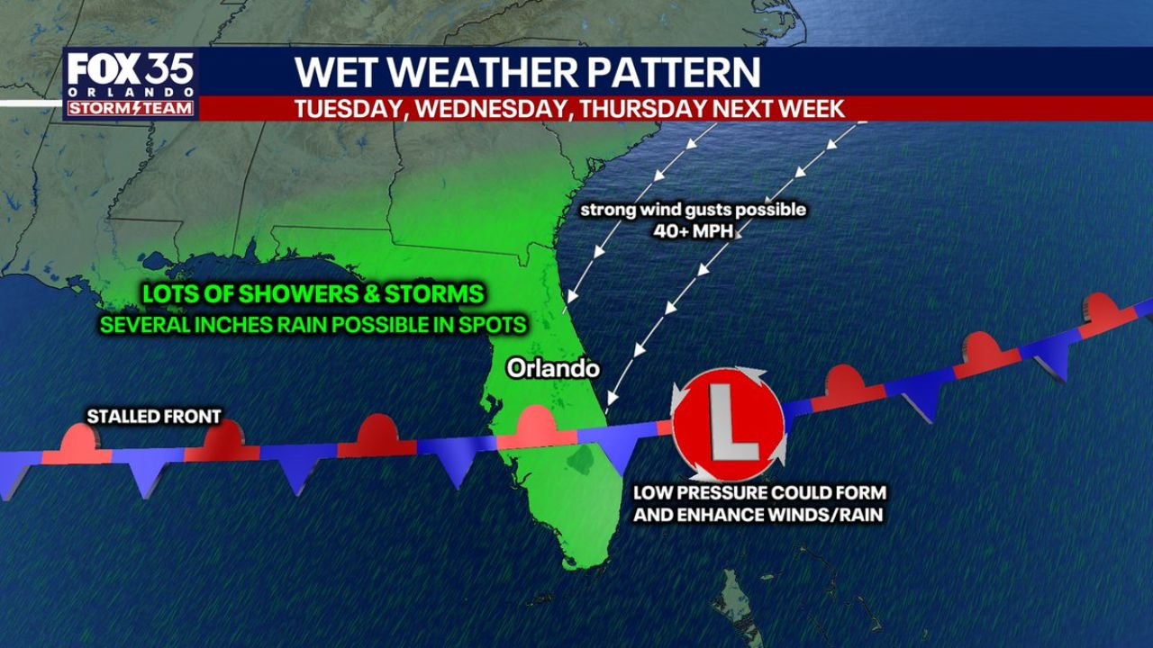
Stalled Front Sets Up Prolonged Wet Weather Across Florida
A stalled frontal boundary is expected to linger across the region, creating the setup for multiple days of unsettled weather conditions. This type of pattern typically allows waves of moisture and storm development to repeatedly move across the state.
Forecast signals indicate numerous showers and storms, with some areas potentially seeing several inches of rainfall, especially where storms repeatedly track over the same locations. Cities including Orlando, Jacksonville, and coastal regions could experience periods of steady rain mixed with thunderstorms.
Alongside the rain, gusty winds could exceed 40 mph, particularly near the coast, where pressure gradients tighten due to nearby systems.
Potential Low Pressure System May Enhance Rain and Wind Threat
One of the key factors in this evolving forecast is the possibility of a non-tropical low pressure system forming off Florida’s east coast. While not expected to become tropical in nature, this system could still play a major role in boosting rainfall totals and increasing wind speeds.
If this low develops as projected, it would likely track northeast into the Atlantic late next week, but not before delivering enhanced rain bands and gusty conditions along Florida’s east coast.
Areas from Miami to Daytona Beach and Jacksonville could see the greatest impacts, including heavier rainfall totals and stronger wind gusts compared to inland locations.
Heaviest Rain Focused on Eastern Florida While Other Areas See Lighter Totals
Rainfall projections suggest a sharp gradient across the state, with heavier totals expected along eastern Florida, while parts of the Gulf Coast may see lighter accumulations.
Some locations could receive a couple of inches of rain, while isolated pockets—especially near the coast—could see locally higher totals depending on storm track and intensity.
This pattern may also bring much-needed drought relief in some areas, though localized flooding cannot be ruled out if heavier bands persist.
Cooler, Gloomy Conditions Expected With Impact on Travel Plans
Temperatures across Florida are expected to drop closer to the low 70s, a noticeable shift from recent warmer conditions. Combined with persistent cloud cover and rain chances, the overall feel will be cooler and more unsettled.
This could impact outdoor plans, particularly in high-traffic destinations like Orlando theme parks, where midweek conditions may remain cloudy, damp, and occasionally stormy.
As the forecast continues to evolve, timing and intensity of storms will become clearer, but early signals strongly suggest a wet and active stretch of weather across Florida next week.
For continued updates on Florida weather patterns, storm developments, and regional forecasts, visit ChicagoMusicGuide.com.