Chicago, St Louis, Memphis and Little Rock Highlighted as April 13 Severe Weather Setup Signals Busy Tornado Stretch Across Midwest and South
CHICAGO, ILLINOIS — A significant uptick in severe weather activity is being signaled across the central United States, with forecast models pointing toward a busy stretch of storms and possible tornadoes around April 13, impacting major cities including Chicago, St Louis, Memphis, Little Rock, and surrounding regions.
After a brief lull in storm activity, atmospheric patterns are expected to re-align in a way that supports widespread severe weather development, particularly across the Midwest and Lower Mississippi Valley.
April 13 Emerging as Key Date for Severe Weather Risk
Forecast guidance highlights the April 13–14 timeframe as a period where tornado potential could increase notably, especially across:
- Chicago and northern Illinois
- St Louis and central Missouri
- Memphis and western Tennessee
- Little Rock and much of Arkansas
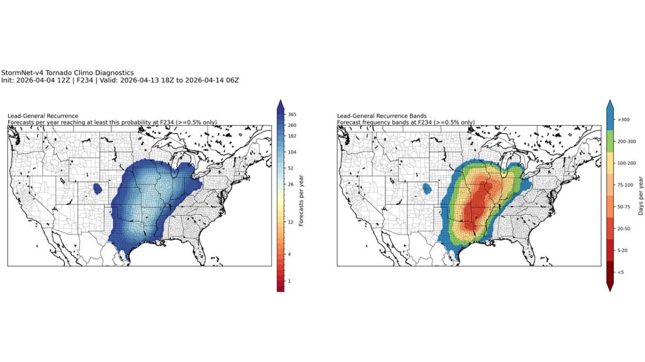
Climatology-based model diagnostics show a broad corridor of heightened tornado probability, stretching from the southern Plains through the Midwest, aligning with regions that frequently experience spring severe weather outbreaks.
This setup suggests the potential for multiple storm systems or a prolonged severe weather window, rather than a single isolated event.
Why This Setup Is Raising Concern
The expected increase in storm activity is tied to a combination of classic springtime severe weather ingredients, including:
- Strengthening jet stream energy across the central U.S.
- Increasing warm, moist air from the Gulf of Mexico
- Enhanced wind shear across key storm corridors
These factors can combine to produce organized thunderstorms capable of rotating, increasing the risk for tornado development, damaging winds, and large hail.
Cities like St Louis and Memphis sit in a particularly favorable zone where instability and wind dynamics often overlap, making them areas to watch closely as the pattern evolves.
Midwest and Southern States in Focus
The geographic focus of this developing threat spans a wide region, including:
- Illinois, Missouri, Arkansas, and Tennessee
- Parts of Kansas, Oklahoma, and Texas extending northward
For cities such as Chicago, St Louis, Little Rock, and Memphis, this could mean a return to active storm tracking conditions, especially if timing aligns with peak daytime heating.
The setup also suggests that storms could organize into larger systems, potentially producing multiple severe weather hazards across several states simultaneously.
Pattern May Continue Beyond April 13
Beyond the initial surge around April 13, longer-range signals indicate that the active severe weather pattern may persist into mid-April, keeping much of the central U.S. under continued threat for additional storm systems.
This extended activity window increases the likelihood of:
- Repeated rounds of thunderstorms
- Accumulated storm impacts across multiple days
- Higher overall severe weather frequency during this period
Residents across the Midwest and South should begin preparing for rapidly changing weather conditions, especially as more detailed forecasts become available closer to the event.
As always during spring, conditions can evolve quickly, and even slight changes in timing or atmospheric setup can significantly impact storm intensity and location.
For the latest severe weather updates, storm outlooks, and regional coverage, visit ChicagoMusicGuide.com and stay informed as this developing weather pattern takes shape.