Corpus Christi, San Antonio and Laredo Under Marginal Severe Storm Risk as Damaging Winds Lead Weekend Weather Threat in South Texas
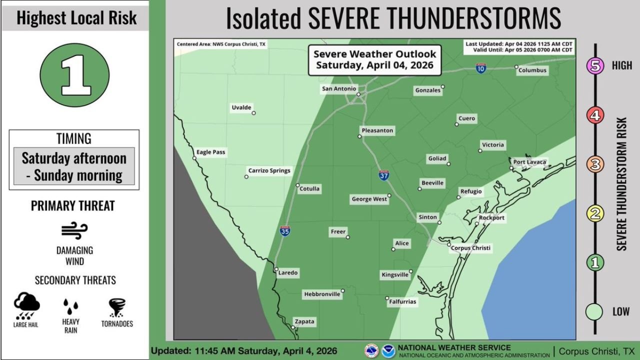
CORPUS CHRISTI, TEXAS — A Marginal Risk (Level 1 of 5) for severe thunderstorms is in place across Corpus Christi, San Antonio, Laredo, and much of South Texas, with storms expected to develop from Saturday afternoon through early Sunday morning, bringing the potential for damaging winds, hail, and heavy rainfall.
While the overall threat level remains on the lower end of the severe weather scale, conditions are still supportive of isolated strong storms, and residents across the region are being advised to stay alert as storms move through.
Timing and Areas Most Likely to See Storms
The primary window for storm activity is expected to begin Saturday afternoon, continuing into the overnight hours and early Sunday morning.
The areas most at risk include:
- Corpus Christi and coastal South Texas
- San Antonio and surrounding inland regions
- Laredo and areas near the Rio Grande
- Communities including Victoria, Beeville, Kingsville, Alice, and Sinton
Storm coverage is expected to be scattered, meaning not every location will see severe weather, but any storm that does develop could briefly intensify.
Primary and Secondary Threats Explained
The main concern with this setup is damaging wind gusts, which can:
- Knock down tree limbs
- Cause localized power outages
- Create hazardous travel conditions
In addition to winds, secondary threats include:
- Small to marginally severe hail
- Heavy downpours, which could lead to temporary street flooding
- A low but non-zero chance of isolated tornadoes, especially if storms become more organized
Even in a Level 1 risk environment, these hazards can still produce localized impacts, particularly in areas directly under stronger storm cells.
Why the Severe Risk Remains Limited
Despite the presence of storms, the overall environment is only marginally supportive of severe weather, meaning:
- Storm organization may be limited
- Stronger storms will likely be isolated rather than widespread
- Severe conditions may be short-lived
This type of setup is common during spring transitions, where instability is present but not fully aligned with stronger atmospheric dynamics needed for a higher-end outbreak.
Cities like San Antonio and Corpus Christi may experience periods of rain and thunderstorms, but not all storms will reach severe limits.
What Residents Should Watch For Overnight
As storms move into the evening and overnight hours, visibility and awareness can become more challenging, increasing the importance of monitoring conditions.
Residents across South Texas, especially in Corpus Christi, Laredo, and Victoria, should:
- Stay updated with weather alerts
- Be prepared for brief strong wind bursts
- Watch for heavy rainfall reducing visibility on roads
Although the overall severe risk is low, nighttime storms can still produce sudden impacts, particularly if they strengthen unexpectedly.
As South Texas continues through an active spring weather pattern, staying informed is key. For more updates on severe weather, storm outlooks, and regional coverage, visit ChicagoMusicGuide.com and keep track of changing conditions across your area.