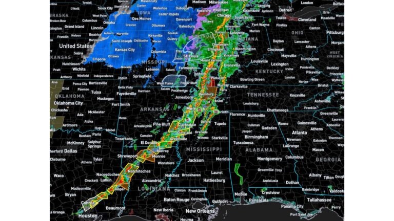
Chicago, Indianapolis and St Louis See Rare 3-Day Dry Window as Planting Conditions Improve Across Midwest and Plains
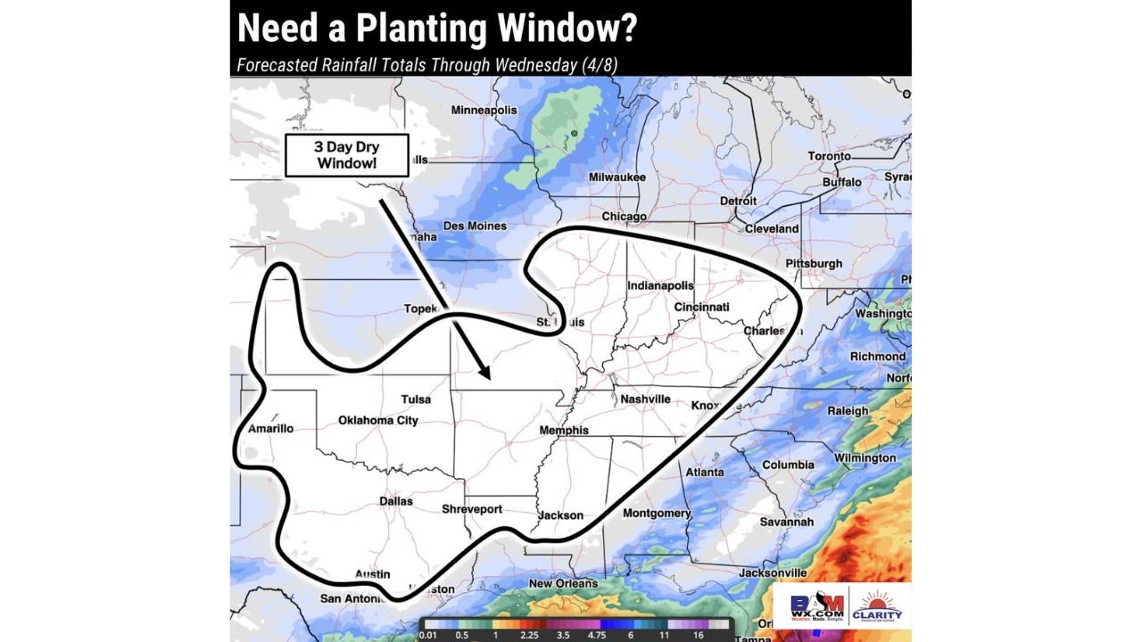
CHICAGO, ILLINOIS — After a stretch of much-needed rainfall across the Plains and Midwest, a valuable 3-day dry window is emerging through Wednesday, offering improved conditions for cities like Chicago, Indianapolis, and St. Louis as the early planting season begins.
Forecast data highlights this period as a critical opportunity for agricultural activity, especially as wetter weather is expected to return later in the week, potentially limiting field access once again.
Dry Window Expands Across Plains and Midwest
A broad region of drier weather conditions is expected to stretch from:
- Amarillo and Oklahoma City
- Through St. Louis and Chicago
- Extending into Indianapolis and Cincinnati
This dry zone will allow soils to:
- Drain after recent rainfall
- Become more accessible for planting operations
- Support fieldwork across multiple states
The 3-day stretch is particularly important given the recent pattern of frequent precipitation, which has slowed early-season agricultural progress in parts of the Midwest and central Plains.
Cities such as Chicago and Indianapolis will experience a noticeable break from rainfall, with limited precipitation expected through Wednesday.
Why This Window Matters for Planting Season
This period is being closely monitored because:
- Spring planting timelines are tightening
- Farmers rely on short dry periods to prepare fields
- Soil moisture levels are currently favorable but need drying time
The balance between adequate moisture and workable soil conditions is critical, and this window provides:
- A chance to accelerate planting schedules
- Opportunities to avoid delays caused by saturated ground
- Better conditions for equipment access across fields
Regions near St. Louis, Memphis, and parts of the Ohio Valley are also included in this favorable zone, increasing the geographic impact of this dry stretch.
Rain Returns Later in the Week
While early-week conditions remain favorable, forecast models indicate a return to wetter weather patterns beyond Wednesday, especially across:
- The central Plains
- Portions of the Midwest
- Areas extending toward the Southeast
Rainfall totals later in the week are expected to increase, particularly:
- Along the Gulf Coast and Southeast U.S.
- Gradually pushing northward toward Midwest regions
This shift means the current dry period is temporary, reinforcing the importance of utilizing the short window before conditions become wetter again.
Regional Outlook and What to Expect
Across key cities:
- Chicago: Dry and stable conditions through midweek, ideal for field activity
- Indianapolis: Similar dry stretch with improved ground conditions
- St. Louis: Positioned near the center of the dry zone, benefiting significantly
Meanwhile:
- Areas farther east may begin seeing rain returning sooner
- Southern regions could experience heavier rainfall later in the week
This evolving pattern highlights a classic spring transition, where short dry breaks are quickly followed by renewed storm activity.
A Narrow Opportunity Before the Next Weather Shift
The current setup offers a brief but important opportunity across the Midwest and Plains, especially for those tracking planting schedules and soil conditions.
With rainfall expected to return after Wednesday, this 3-day stretch may be one of the most usable early-season windows so far.
For more updates on Midwest weather patterns, planting forecasts, and regional outlooks, visit ChicagoMusicGuide.com and stay informed as changing conditions impact communities across the region.