Miami Florida Storm System Brings Gusty Winds and Heavy Rain From Tuesday Through Thursday With Flooding Risk in Fort Lauderdale and West Palm Beach
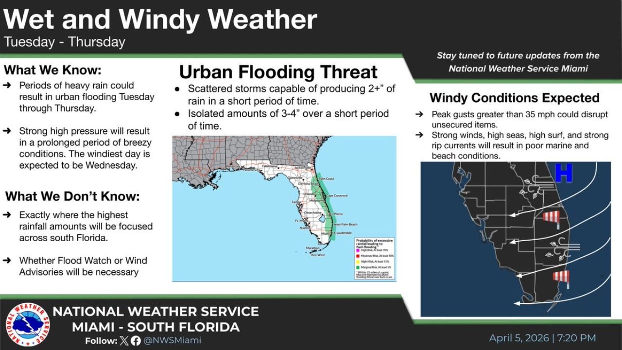
MIAMI, FLORIDA — A developing weather pattern is set to bring periods of heavy rainfall and gusty winds across South Florida from Tuesday through Thursday, with cities including Miami, Fort Lauderdale, and West Palm Beach facing the potential for urban flooding and hazardous coastal conditions.
While this will not be a continuous rain event, forecasters warn that short bursts of intense rainfall combined with strong winds could create localized but impactful disruptions, especially in densely populated areas.
Heavy Rainfall Could Trigger Urban Flooding Concerns
The most significant concern with this system is the potential for urban flooding, particularly in low-lying and poorly drained areas across South Florida.
Forecast guidance indicates:
- Scattered storms may produce over 2 inches of rain in a short period
- Isolated locations could receive 3 to 4 inches of rainfall quickly
- Rainfall intensity, rather than duration, will be the key risk factor
Cities like Miami and Fort Lauderdale, which are especially vulnerable to drainage issues, could see water accumulation on roadways during peak rainfall periods. Timing and storm placement will determine exactly where the heaviest impacts occur.
Strong Winds and Coastal Hazards Expected Midweek
In addition to heavy rain, gusty winds are expected to intensify across the region, particularly on Wednesday, which is likely to be the windiest day of the week.
Wind impacts may include:
- Wind gusts exceeding 35 mph, capable of moving unsecured objects
- Rough marine conditions with high seas and strong surf
- Increased risk of rip currents along Atlantic beaches
Coastal cities such as West Palm Beach and Miami Beach could experience deteriorating beach conditions, making swimming and boating activities potentially dangerous.
What Makes This System Uncertain
Despite growing confidence in a wet and windy pattern, there are still key uncertainties:
- The exact placement of the heaviest rainfall bands remains unclear
- Localized flooding could vary significantly between neighborhoods
- It is still uncertain whether Flood Watches or Wind Advisories will be issued
This means some areas may see only moderate rain, while others could experience intense downpours within a short timeframe.
Timeline of Impacts Across South Florida
The system is expected to unfold in phases:
- Tuesday: Increasing clouds, scattered showers begin developing
- Wednesday: Peak impacts with strong winds and heavier rain bursts
- Thursday: Continued unsettled weather with lingering showers and breezy conditions
Residents across Miami, Fort Lauderdale, and West Palm Beach should prepare for changing conditions throughout this period.
How Residents Should Prepare
With both heavy rainfall and gusty winds expected, residents are encouraged to:
- Secure outdoor items ahead of increasing winds
- Monitor local forecasts for flood-prone areas
- Allow extra travel time during periods of heavy rain
- Avoid flooded roadways, even if water appears shallow
Even though this is not expected to be a prolonged storm system, the short-duration intensity of rainfall and wind could still create meaningful disruptions.
As weather patterns continue to shift across the U.S., staying informed is essential. For more updates on storm systems, regional weather alerts, and detailed forecasts, visit ChicagoMusicGuide.com and stay prepared for changing conditions.