Des Moines Iowa Snow Chances Rise Monday Night Into Tuesday With Higher Risk Across Atlantic Creston and Lamoni Areas
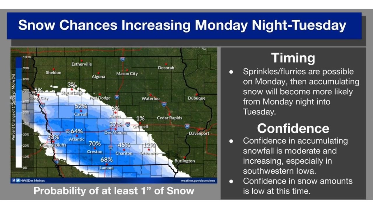
DES MOINES, IOWA — After a calm and pleasant Easter Sunday, a shift in weather is expected across southwest Iowa, where snow chances are increasing Monday night into Tuesday, particularly impacting cities like Des Moines, Atlantic, Creston, and Lamoni.
Forecast data shows growing confidence in accumulating snowfall, although uncertainty remains regarding exact totals as the system develops.
Where Snow Chances Are Highest Across Southwest Iowa
The most likely area for accumulating snow is focused across the southwestern half of Iowa, where probabilities for at least 1 inch of snowfall are notably higher.
Key areas include:
- Creston and Lamoni, where probabilities reach around 65–70%
- Atlantic, with chances near 60% or higher
- Des Moines, where probabilities are slightly lower but still significant
- Chariton and surrounding communities, with moderate snow potential
Further north and east, including areas like Ames, Waterloo, and Cedar Rapids, the chances drop off significantly, with only minimal probabilities for accumulation.
Timing of Snowfall From Monday Into Tuesday
The timeline of this event is expected to unfold gradually:
- Monday: Light sprinkles or flurries may begin developing
- Monday Night: Transition toward more organized snowfall
- Tuesday: Peak period for potential accumulation across southwest Iowa
This overnight-to-morning transition increases the likelihood that snowfall could impact early Tuesday travel, especially in cities like Des Moines and Creston.
Confidence Increasing but Snow Totals Remain Uncertain
Forecast confidence is described as moderate and increasing when it comes to whether snow will occur, especially in southwestern Iowa.
However, there is still low confidence in exact snowfall amounts, meaning:
- Some areas could see only light accumulation
- Others may receive more noticeable snowfall if conditions align
- Small shifts in storm track could significantly impact totals
This type of setup often leads to sharp gradients, where nearby cities experience very different outcomes.
What This Means for Travel and Daily Plans
Even with uncertainty in totals, the timing and potential for accumulation could still create impacts, including:
- Slick road conditions during early Tuesday hours
- Reduced visibility during periods of snowfall
- Changing conditions depending on exact storm placement
Residents in cities like Des Moines, Atlantic, and Lamoni should stay alert for updates as conditions evolve.
A Quick Reminder as Spring Weather Fluctuates
This system highlights how spring weather in the Midwest can shift rapidly, moving from warm and pleasant conditions to wintry precipitation within a short timeframe.
While this is not expected to be a major winter storm, it still has the potential to create localized disruptions, especially in areas with higher snow probabilities.
For continued updates on Midwest weather patterns, snowfall forecasts, and regional alerts, visit ChicagoMusicGuide.com and stay informed as conditions develop.