Chicago Illinois Detroit Michigan And Cleveland Ohio Brace For Sudden Temperature Drop As Canadian Cold Surge Brings Snow Back To Midwest And Northeast Cities
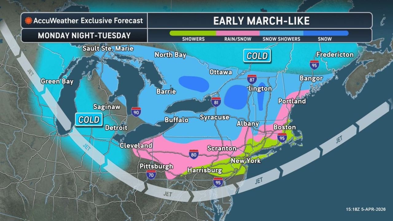
CHICAGO, ILLINOIS — A powerful second surge of cold Canadian air is set to sweep across the Midwest and Northeast, bringing a sharp temperature drop and a return of snow showers to cities including Chicago, Detroit, Cleveland, Buffalo, and Boston from Monday night into Tuesday.
Cold Canadian Air Mass Targets Midwest And Great Lakes Cities
The incoming system is driven by a strong push of cold air descending from Canada, reinforced by an active jet stream dipping across the Great Lakes region.
Cities expected to feel the immediate impact include:
- Chicago, Illinois: Noticeable drop in temperatures with scattered snow showers possible
- Detroit, Michigan: Transition to colder conditions with lake-enhanced snow activity
- Cleveland, Ohio: Likely to see a mix of rain changing to snow overnight
- Green Bay and Saginaw: Already positioned closer to the cold core, increasing chances for persistent snow showers
This setup resembles a late-season winter pattern, often described as “early March-like conditions,” despite the calendar moving deeper into spring.
Snow, Rain-Snow Mix, And Travel Impacts Across The Northeast
As the cold air pushes eastward, it will collide with lingering moisture, creating a band of mixed precipitation stretching across the Northeast corridor.
Key impacts expected:
- Buffalo, Syracuse, and Albany (New York): Periods of snow showers with localized accumulation
- Scranton and Harrisburg (Pennsylvania): A rain-to-snow transition zone, increasing travel concerns
- New York City and Boston: Primarily rain or rain/snow mix, but colder air could briefly support wet snow
- Portland, Maine and Bangor: Higher confidence in snow showers due to colder temperatures
The most active zone appears along an I-80 to I-95 corridor, where changing precipitation types could create slippery roads during early morning hours.
Temperature Drop Will Be Sharp And Noticeable
One of the biggest impacts from this system will be the rapid temperature decline, especially across the Midwest and Great Lakes.
- Temperatures will fall well below seasonal averages
- Wind chills will make conditions feel even colder in cities like Chicago, Detroit, and Cleveland
- The return of cold air may briefly halt early spring warming trends
This type of cold surge is typical when Arctic air masses break southward, often bringing brief but impactful winter-like conditions.
What Residents Should Expect During This Short-Lived Pattern
Although the system will be impactful, it is expected to be relatively short-lived. However, residents should prepare for:
- Slippery morning commutes due to snow or mixed precipitation
- Sudden weather changes between rain and snow within hours
- Reduced visibility during bursts of snow showers
- Cold and windy conditions lingering through midweek
Cities like Chicago, Cleveland, and Buffalo may experience the most noticeable disruptions, especially during peak travel times.
Spring Still Ahead Despite This Late-Season Cold Snap
While this cold surge may feel like a setback, it does not signal a return to winter dominance. Instead, it highlights the volatile nature of spring weather across the Midwest and Northeast.
After this system moves through:
- Temperatures are expected to gradually recover
- Snow chances will decrease
- A more typical spring pattern will likely return
For now, however, cities across both regions should remain alert for rapid weather changes and brief winter-like impacts.
Stay updated with the latest weather developments and regional forecasts by visiting ChicagoMusicGuide.com for timely alerts, detailed coverage, and daily updates.