Much-Above-Normal Heat Targeting New York, New England, Georgia and the Carolinas the Week of April 18 While Wildfire Danger Climbs Across Oklahoma, Texas, Colorado and the Entire Southeast
ATLANTA, GA — Two separate but connected weather threats are converging on different corners of the United States this month — and taken together, they paint a picture of a country entering a dangerous stretch of spring weather that demands attention from millions of residents across the South, the Southeast, the Northeast, and the southern Plains simultaneously.
In the East, an official hazardous temperature outlook is now in place for the week of April 18 through 24, flagging much-above-normal heat targeting New York, New England, Pennsylvania, Georgia, the Carolinas, and Florida. In the South and West, a separate wildfire potential outlook for April 2026 is showing above-normal fire danger across Oklahoma, Texas, Colorado, New Mexico, and a vast swath of the Southeast — and the connection between the two threats is not coincidental. The same dry, warm conditions fueling the temperature anomalies are the identical conditions that make wildfires ignite faster, spread further, and resist containment longer.
The Hazardous Heat Outlook: April 18 Through 24
The Climate Prediction Center released its official Risk of Hazardous Temperatures outlook on April 10, 2026, valid for the seven-day period from April 18 through April 24. The map identifies three distinct risk tiers across the eastern United States, each carrying a different probability level and duration window for much-above-normal temperatures.
The High Risk zone — defined as greater than a 60% probability of hazardous above-normal temperatures — is centered on the northeastern corridor and is valid for the opening two days of the outlook window, April 18 and 19. This zone covers New York, New England, Pennsylvania, New Jersey, Delaware, Maryland, and the northern Virginia fringe. A greater than 60% probability designation on a weekly temperature outlook from the Climate Prediction Center represents one of the strongest signals the agency issues. Residents across New York City, Boston, Philadelphia, Baltimore, and surrounding metropolitan areas should prepare for the arrival of significantly above-normal heat during the middle of next week.
The Moderate Risk zone — 40 to 60% probability — covers the Southeast core and is valid through April 20, spanning three days. This zone encompasses Georgia, South Carolina, North Carolina, Tennessee, and the Alabama fringe. Cities including Atlanta, Charlotte, Raleigh, Columbia, and Nashville fall within this moderate-probability above-normal heat corridor. Three consecutive days of well-above-normal temperatures in mid-April across the Deep South carries real health implications, particularly for outdoor workers, elderly residents, and anyone without reliable air conditioning.
The Slight Risk zone — 20 to 40% probability — carries the longest valid window of the three tiers, running from April 18 all the way through April 22. This zone covers the broader Southeast including Florida, the coastal Carolinas, and extends the duration of the above-normal temperature signal the furthest into the week. Miami, Jacksonville, Tampa, Savannah, and the Florida Panhandle all fall within this longer-duration slight risk corridor.
Hazardous Temperature Outlook Data Summary
| Risk Level | Probability | Valid Dates | Primary States and Cities Affected |
|---|---|---|---|
| High Risk | Greater than 60% | April 18 to 19 | New York, New England, Pennsylvania, New Jersey, Maryland, Delaware |
| Moderate Risk | 40 to 60% | April 18 to 20 | Georgia, South Carolina, North Carolina, Tennessee, Alabama fringe |
| Slight Risk | 20 to 40% | April 18 to 22 | Florida, Coastal Carolinas, broader Southeast |
The Wildfire Threat: Where Drought and Heat Collide
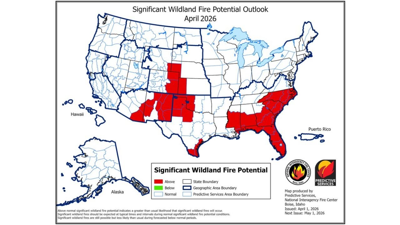
The April 2026 Significant Wildland Fire Potential Outlook, issued by the National Interagency Fire Center on April 1, 2026, identifies multiple large regions of above-normal wildfire potential across the United States this month. Above-normal wildfire potential does not mean fires are guaranteed — it means the conditions of vegetation dryness, wind, low humidity, and heat are combining to create a greater-than-usual likelihood that significant wildland fires will occur if ignition happens.
Three distinct geographic concentrations of elevated wildfire risk stand out in the April 2026 data.
The first and most expansive cluster spans the southern Plains, covering the majority of Oklahoma, central and western Texas, and eastern New Mexico. This zone sits directly within the exceptional drought footprint that has been expanding across the region through late winter and early spring. When drought-stressed vegetation — grass, shrubs, and timber that have received well-below-normal precipitation for months — encounters above-normal heat and low relative humidity, it becomes the equivalent of dry kindling across millions of acres. The combination of much-above-normal temperatures forecast for the region alongside pre-existing exceptional drought conditions creates a wildfire environment that fire managers take extremely seriously.
The second cluster covers the Colorado, Wyoming, and South Dakota corridor, where above-normal fire potential stretches across eastern Colorado, southeast Wyoming, and western South Dakota. Spring is historically the most dangerous wildfire season across this region, when winter snowpack has melted, new vegetation has not yet greened up, and strong wind events can push fires across the landscape faster than suppression resources can respond.
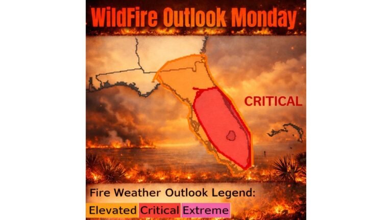
The third cluster — and arguably the most geographically significant given the population centers involved — covers the Southeast. Above-normal wildfire potential is mapped across North Carolina, South Carolina, Georgia, Florida, southern Alabama, and the Mississippi coastal fringe for April 2026. The overlap between this wildfire risk zone and the hazardous temperature outlook for the same region is direct and reinforcing. Above-normal heat dries out vegetation faster, lowers relative humidity, and increases wind-driven fire spread potential. The cities of Raleigh, Charlotte, Atlanta, Jacksonville, Orlando, and Tampa all sit within or adjacent to this elevated wildfire risk zone.
Wildfire Potential Outlook: State-by-State
| Risk Level | States | Key Areas |
|---|---|---|
| Above Normal — Southern Plains | Oklahoma, Texas, New Mexico | Statewide OK, Central/West TX, Eastern NM |
| Above Normal — Central Rockies | Colorado, Wyoming, South Dakota | Eastern CO, SE Wyoming, W. South Dakota |
| Above Normal — Southeast | North Carolina, South Carolina, Georgia, Florida, Alabama (S), Mississippi (coastal) | Raleigh, Charlotte, Atlanta, Jacksonville, Tampa, Orlando |
| Normal | Midwest, Pacific Coast, Mountain West, Northern Plains | No elevated risk |
Regional Breakdown: Who Faces What and When
New York, New England and the Northeast — April 18 to 19
The High Risk designation for the Northeast during April 18 and 19 is the most immediately actionable piece of this outlook for the region’s residents. Much-above-normal temperatures arriving in mid-April can be deceptive — the body has not yet acclimated to heat after a winter and early spring of cool conditions, making heat illness more likely at temperatures that might feel manageable in August. New York City, Boston, Providence, Hartford, Albany, and Philadelphia should all prepare for the possibility of a significant early-season heat event during the opening days of the April 18 to 24 window.
Georgia, the Carolinas and Tennessee — April 18 to 20
The Moderate Risk designation covering Atlanta, Charlotte, Raleigh, Columbia, and Nashville through April 20 arrives on top of an already-elevated wildfire risk for the region. The combination of above-normal heat, dry conditions from existing drought, and above-normal wildfire potential across the Southeast means that outdoor burning bans, elevated fire weather watches, and heat health advisories are all realistic possibilities across this corridor heading into the week of April 18.
Florida and the Coastal Southeast — April 18 to 22
The Slight Risk zone valid through April 22 gives Florida and the coastal Southeast the longest duration above-normal temperature signal in the entire outlook. Combined with above-normal wildfire potential across the state for April 2026, the dry and warm pattern across Florida, Georgia, and the Carolinas carries compounding risk for communities near wildland-urban interface areas — the boundary zones where developed neighborhoods meet forests, scrubland, and other fire-prone vegetation.
Oklahoma, Texas and New Mexico — Wildfire Focus
While the hazardous temperature outlook does not specifically flag Oklahoma, Texas, and New Mexico in the April 18 to 24 window, the wildfire risk data for these states in April 2026 stands on its own as a serious threat. Exceptional drought across Oklahoma and western Texas, combined with the region’s typical spring wind pattern and above-normal wildfire potential, means fire weather conditions can develop rapidly on any given afternoon when temperatures spike, humidity drops, and south winds increase. Residents across Oklahoma City, Tulsa, Amarillo, Lubbock, Midland, and Albuquerque should maintain awareness of local fire weather watches and warnings throughout the month.
Forecast Confidence
Confidence: High for the Heat Outlook, Moderate for the Wildfire Outlook. The Climate Prediction Center hazardous temperature map released April 10 carries strong institutional confidence behind its High and Moderate risk designations for the April 18 to 24 period. The greater than 60% probability flag on the Northeast for April 18 and 19 in particular represents a well-supported signal with multiple data sources in agreement.
The wildfire potential outlook for April 2026 reflects the best available assessment of large-scale conditions as of April 1, 2026, and is subject to evolution as individual weather systems move through the affected regions. Wildfire potential is a background risk assessment, not a day-specific forecast. Actual fire weather conditions are determined by real-time wind, humidity, and temperature on any given day — but the above-normal potential designation means the overall environment this month is more primed for significant fire activity than a normal April across the flagged states.
Residents across every affected region — from New York to Florida, from Oklahoma to Colorado — should monitor local weather authority updates closely as April 18 approaches and throughout the remainder of the month.
More heat outlook and wildfire risk coverage is always on the horizon. Stay informed at ChicagoMusicGuide.com — your source for hazardous temperature and wildfire weather tracking across the Southeast, the Southern Plains, the Northeast, and the entire United States.