Northern Illinois, Iowa and Wisconsin Brace for Explosive Severe Weather Tuesday Evening as Tennis Ball Hail, 75 MPH Winds and Tornadoes Threaten the I-80 Corridor Between 5 PM and Midnight
CHICAGO, IL — A severe weather setup with serious credentials is taking shape for Tuesday evening across northern Illinois, Iowa, and Wisconsin — and the data behind it is not subtle. A strong atmospheric cap that has been holding storms in check throughout Tuesday will break down between 4 and 6 PM, and when it does, forecasters are expecting explosive convection to erupt across the region and continue through midnight and beyond.
The window that matters most for northern Illinois runs from 5 PM to midnight Tuesday, with the greatest storm convergence expected along and north of Interstate 80 — a corridor that cuts directly through some of the most densely populated communities in the state.
Why Tuesday Evening Is So Dangerous
The cap — a layer of warm air in the middle atmosphere that acts like a lid on a pressure cooker, preventing storms from firing prematurely — has been allowing extreme destabilization to build at the surface across Iowa, Wisconsin, and northern Illinois all day Tuesday. Every hour the cap holds, more energy loads into the atmosphere below it. When that cap finally breaks between 4 and 6 PM Tuesday evening, the accumulated energy releases all at once.
This is the precise mechanism that produces the most violent and rapidly intensifying thunderstorms. Storms that develop after a cap breaks into an extremely unstable environment do not ease into existence — they explode upward, organize quickly into supercells, and immediately begin producing severe hazards.
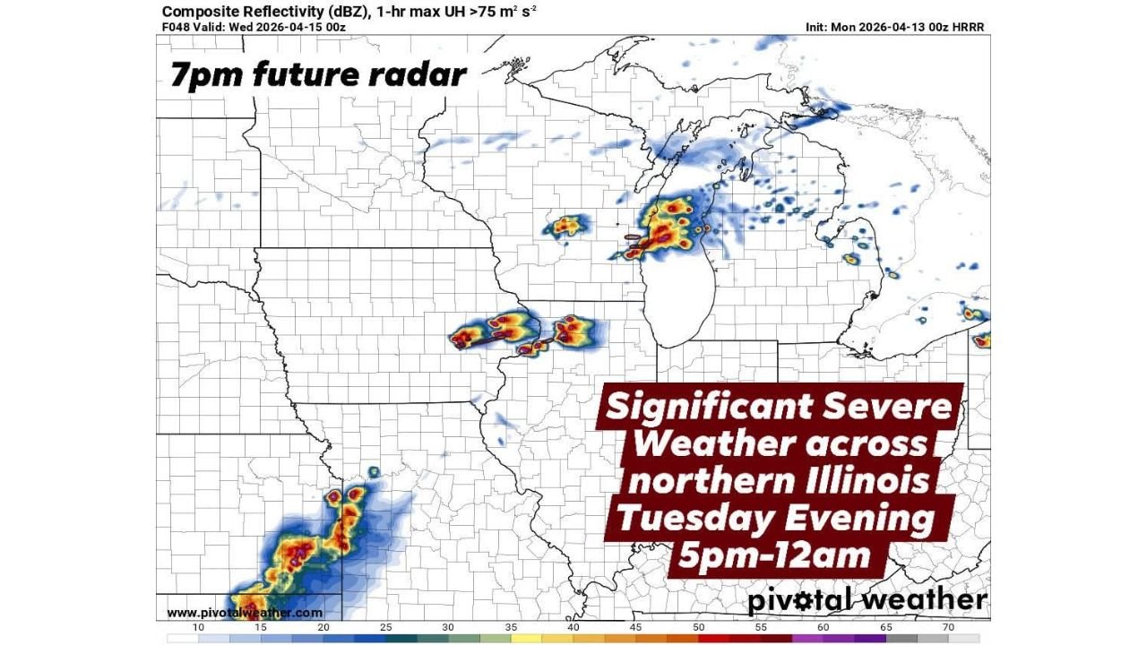
Current model data, initialized Monday April 13, shows the 7 PM future radar projection placing organized storm clusters across northern Illinois and extending into Wisconsin and Michigan, with the highest updraft helicity values — the measure of how strongly a storm is rotating — concentrated along the I-80 corridor and north.
What Storms Will Be Capable of Tuesday Night
Storms across northern Illinois on Tuesday evening are forecast to be capable of producing all three major severe weather hazards simultaneously:
Very large hail ranging from quarter size to tennis ball size — quarter-sized hail measures about one inch in diameter and can damage vehicle paint and crack windshields, while tennis ball-sized hail measures approximately 2.5 inches and is capable of shattering glass, punching through roofing material, and causing serious injury to anyone caught outdoors.
Significant damaging wind gusts exceeding 75 mph — winds at this threshold are equivalent to a Category 1 hurricane and are capable of snapping large trees, downing power lines across wide areas, causing structural damage to buildings, and making driving conditions on highways like I-80 extremely dangerous.
Isolated tornadoes — the rotating supercell environment that produces tennis ball hail and extreme wind gusts is the same environment capable of generating tornadoes. The tornado threat is not the headline hazard Tuesday but it is real and cannot be dismissed.
Severe Weather Timeline and Data Summary
| Threat | Details | Timing |
|---|---|---|
| Cap Break and Storm Initiation | Explosive convection begins | 4 to 6 PM Tuesday |
| Primary Severe Weather Window | Northern Illinois I-80 corridor | 5 PM to Midnight |
| Hail Size | Quarter to tennis ball size | 5 PM onward |
| Wind Gusts | Exceeding 75 mph | Evening hours |
| Tornado Threat | Isolated | Evening through midnight |
| Storm Weakening | Gradual decay | Wednesday morning |
State-by-State Breakdown
Illinois — Northern Counties Along and North of I-80 The highest risk zone for Tuesday evening. The best storm convergence is explicitly forecast along and north of Interstate 80, placing communities across northern Illinois — including the broader Chicago metro area and surrounding counties — in the direct path of what could be an extremely active severe weather corridor between 5 PM and midnight. Tennis ball hail, 75-plus mph wind gusts, and isolated tornadoes are all within the forecast envelope. Residents across northern Illinois should be indoors with a shelter plan active before 5 PM Tuesday.
Iowa Iowa is identified as one of the three states where extreme destabilization is building under the cap through Tuesday. Storm initiation across Iowa during the 4 to 6 PM cap-break window will feed organized severe weather that tracks eastward into northern Illinois through the evening. Severe thunderstorms with large hail and damaging winds are expected across Iowa ahead of the main Illinois event.
Wisconsin Wisconsin falls within the destabilization zone and will see severe storm activity as the system pushes northward through the evening. The future radar projection shows organized storm clusters extending into Wisconsin by 7 PM, with large hail and damaging winds the primary threats as the line pushes northeast.
Forecast Confidence
Forecast Confidence: Moderate to High. The cap-break mechanism driving Tuesday evening’s event is well-supported across multiple model runs initialized Monday. The timing window of 4 to 6 PM for explosive storm initiation is consistent and the 5 PM to midnight severe weather window for northern Illinois carries strong model agreement. The primary uncertainty is exactly how quickly individual storms organize after the cap breaks and whether discrete supercell mode is maintained long enough to maximize the hail and tornado threat before the system transitions to a squall line.
Residents across northern Illinois, Iowa, and Wisconsin should treat Tuesday afternoon as a preparation window — identify shelter locations, charge devices, and have a weather alert source active before evening storms arrive.
More severe weather coverage is always on the horizon. Stay informed at ChicagoMusicGuide.com — your source for tornado, hail, and severe storm tracking across northern Illinois, Iowa, Wisconsin, and the entire United States.