The Active Storm Pattern Refuses to Quit as Several More Rounds of Rain Target Texas, Oklahoma, St. Louis, Cincinnati and Ohio Through April 25 While the Pacific Northwest and Northern Plains Stay Dry
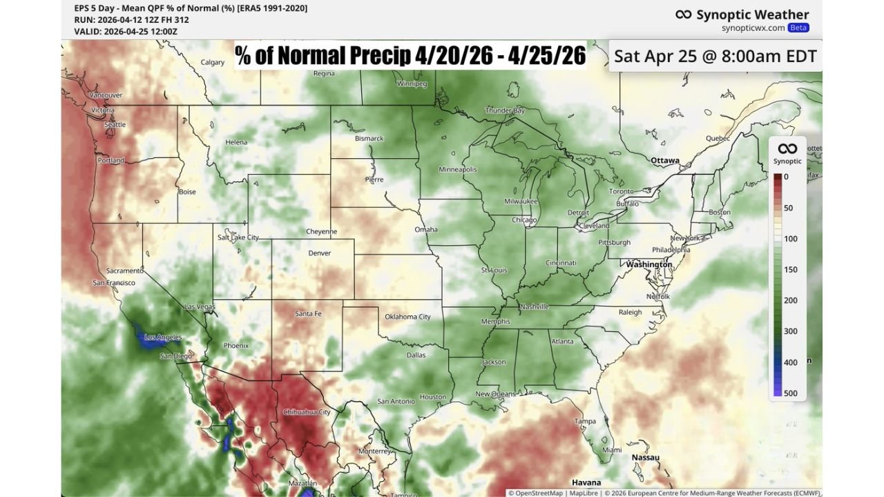
DALLAS, TX — The relentless spring storm pattern that has dominated the central United States through April is not finished yet. The latest Week 2 precipitation outlook, valid from April 20 through April 25, 2026, confirms that several more rounds of rain are on the way across a corridor stretching from Texas through Oklahoma, St. Louis, Cincinnati, and Ohio — while the areas surrounding that active zone trend notably drier and the first hints of a pattern change begin to appear toward the start of May.
The message from the data is straightforward: if you live between Texas and Ohio, keep the umbrella handy for at least another week.
What the Week 2 Outlook Is Showing
The precipitation outlook measures rainfall as a percentage of normal — meaning how much rain is expected compared to what is climatologically typical for that period. Values above 100% mean above-normal rainfall. Values below 100% signal a drier-than-normal stretch.
The green corridor dominating the map from April 20 through April 25 covers the heart of the central and eastern United States with above-normal to well-above-normal precipitation values. The deepest greens — representing 150% to 300% of normal rainfall — are concentrated across the Texas, Oklahoma, Arkansas, Missouri, Tennessee, and Ohio Valley corridor. This is where multiple storm systems are expected to track during the Week 2 window, delivering repeated rounds of rain and potentially thunderstorms to an area that has already seen significant moisture accumulation through the first half of April.
Dallas, Oklahoma City, St. Louis, Memphis, Nashville, Cincinnati, and Cleveland all fall within the above-normal precipitation corridor for this period. The Chicago area sits at the northern fringe of the active zone, with near-normal to slightly above-normal rainfall expected.
The Dry Zones: Who Gets a Break
Not every part of the country is in the wet pattern. The outlook shows a clear and significant dry signal across two distinct regions.
The Pacific Northwest — including Seattle, Portland, and the Oregon coast — is showing well-below-normal precipitation for the April 20 to 25 window, with red and orange values indicating less than 50% of normal rainfall across much of Washington and Oregon. This extends the already-dry spring pattern across the region and adds to wildfire concern heading into late April.
The Northern Plains and Upper Midwest — including Bismarck, Pierre, and the Dakotas — also trend drier than normal during this period, sitting largely outside the active storm track that is keeping the central corridor wet.
The Desert Southwest including Phoenix and Las Vegas shows near-zero precipitation as expected for this time of year.
Week 2 Precipitation Outlook by Region
| Region | Precipitation Forecast | Key Cities |
|---|---|---|
| Texas to Ohio Corridor | 150% to 300% of normal | Dallas, OKC, St. Louis, Cincinnati, Cleveland |
| Tennessee and Mid-South | Above normal | Memphis, Nashville, Jackson |
| Southeast | Near to slightly above normal | Atlanta, Raleigh, Charlotte |
| Great Lakes | Near normal to slightly above | Chicago, Detroit, Milwaukee |
| Pacific Northwest | Well below normal, 25 to 50% | Seattle, Portland |
| Northern Plains | Below normal | Bismarck, Pierre, Fargo |
| Desert Southwest | Near zero, normal dry season | Phoenix, Las Vegas |
State-by-State Breakdown for April 20 to 25
Texas Dallas, Houston, San Antonio, and Oklahoma City all fall inside the above-normal rainfall corridor. Several rounds of rain are expected across Texas during this period, consistent with the active southern Plains storm track that has defined April 2026. Flash flooding potential will need to be monitored with each system given the already-saturated soils across portions of the state.
Oklahoma, Arkansas and Missouri The corridor from Oklahoma City through St. Louis sits inside some of the highest above-normal precipitation values on the entire map. Multiple storm systems tracking through this zone between April 20 and 25 will keep rainfall totals elevated and maintain the potential for locally heavy downpours with each passing system.
Tennessee, Kentucky and Ohio Nashville, Cincinnati, and Cleveland fall within the active precipitation zone through April 25. The Ohio Valley corridor has been a repeated target for storm systems throughout April, and the Week 2 outlook confirms that pattern continues through at least the end of the month.
Illinois and the Great Lakes Chicago and the Great Lakes region sit at the northern fringe of the active corridor with near-normal to slightly above-normal rainfall expected. Storm systems may clip this area but the heaviest totals are expected to remain south and southwest of the metro.
Pacific Northwest — Washington and Oregon Seattle and Portland trend significantly drier than normal through April 25, continuing a dry spring pattern across the region. Below-normal precipitation combined with above-normal temperatures across the Pacific Northwest keeps wildfire weather concerns elevated heading into late April and early May.
What Changes at the Start of May
Current analysis is already flagging the start of May as a potential transition point where the active central US storm pattern may begin to break down and drier conditions could become more widespread across the corridor that has seen repeated rainfall through April. This is not a confirmed forecast — it is an emerging signal worth watching as the pattern evolves.
Forecast Confidence
Forecast Confidence: Moderate. Week 2 precipitation outlooks carry inherent uncertainty in the exact placement and timing of individual storm systems. What the data is highly confident about is the overall pattern direction — the central corridor from Texas to Ohio remains in an active, above-normal rainfall regime through April 25, while the Pacific Northwest and Northern Plains trend drier. The specific rainfall totals for any given city within the active zone will depend on how individual storm systems track during this period.
More active pattern and precipitation outlook coverage is always on the horizon. Stay informed at ChicagoMusicGuide.com — your source for weekly storm pattern tracking across Texas, the Ohio Valley, and the entire United States.