Baltimore’s Summer-Like Heat Wave Will Not Last as Upper-Level Pattern Data Shows a Significant Cool Down Arriving Next Sunday With a Deep Trough Sweeping the Northeast by April 20
BALTIMORE, MD — The summer heat gripping Baltimore and the broader mid-Atlantic region right now has an expiration date — and it is coming sooner than the temperatures outside might suggest. Upper-level atmospheric pattern data valid for Monday, April 20, 2026 shows a dramatic and decisive shift sweeping through the Northeast, with a powerful trough — a deep dip in the jet stream that pulls cold air southward — positioned to replace the current warmth with significantly cooler conditions beginning next Sunday.
For Baltimore residents enduring what feels like a July afternoon in mid-April, the relief is about one week away.
What the Upper-Level Pattern Is Showing
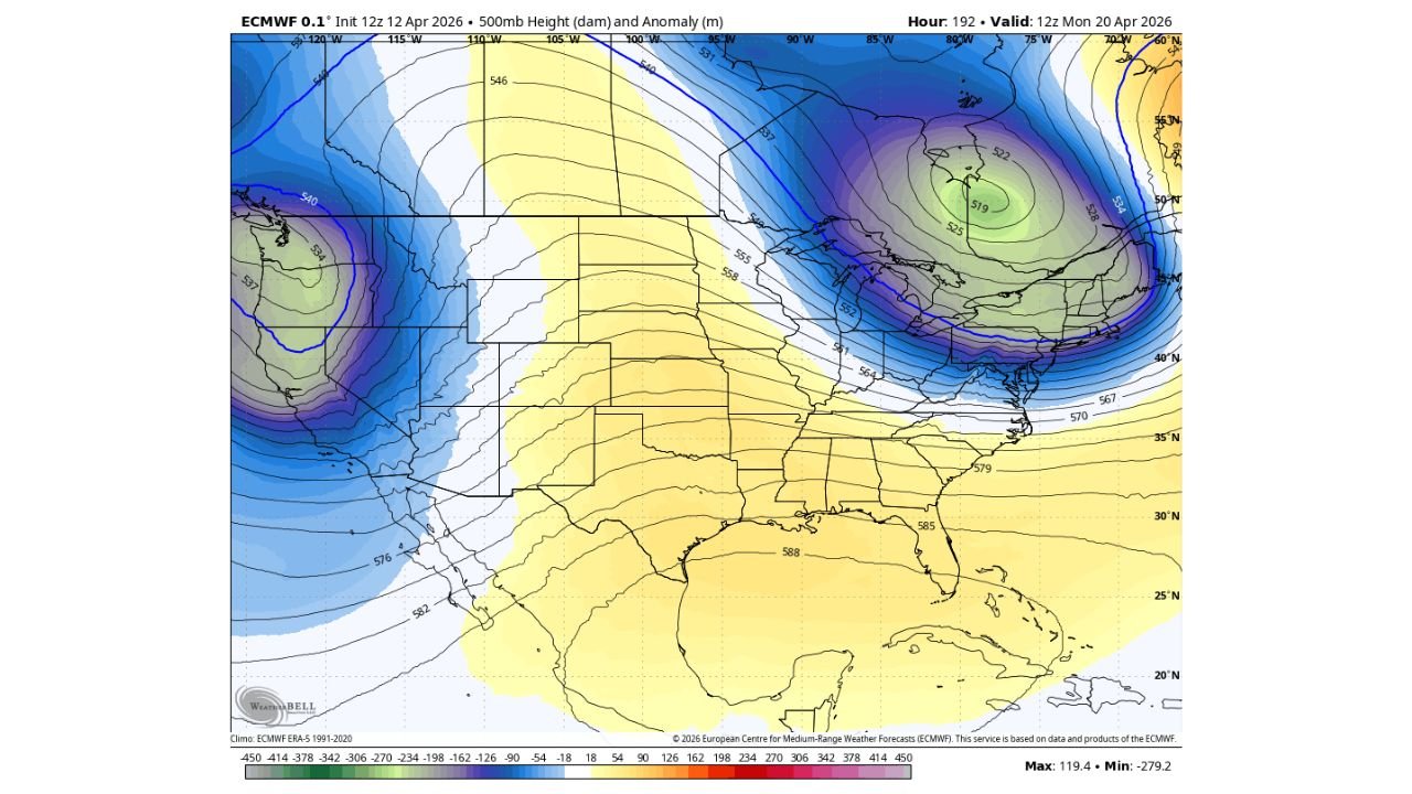
The atmospheric map valid for April 20 tells a clear story at the 500mb level — approximately 18,000 feet above the surface, where the steering currents that control surface weather patterns originate. At this level, forecasters look at height anomalies — areas where the atmosphere is running higher or lower than normal — to identify where warmth and cold air are positioned.
Right now, a sprawling ridge of high pressure — depicted in warm yellow and orange tones on the pattern map — is sitting across the southern and central United States, pushing well above-normal warmth northward into the mid-Atlantic and Northeast. This is the direct cause of Baltimore’s current summer-like heat.
By April 20, that ridge is no longer in control of the Northeast. Current model data shows a deep, negatively tilted trough — shown in the bold blue and purple colors on the map — digging sharply into eastern Canada and the northeastern United States. The 500mb height values across the Great Lakes and Northeast corridor drop dramatically, with the trough center positioned over eastern Canada and its southern reach extending directly into the mid-Atlantic region.
The anomaly values associated with this trough are strongly negative — meaning the atmosphere at that level will be running well below the 1991 to 2020 climatological average for late April. Below-normal heights at 500mb translate directly to cooler-than-normal temperatures at the surface. The deeper and more amplified the trough, the sharper and more significant the cool-down that follows at ground level.
The Heat Now vs. What Arrives April 20
| Feature | Current Pattern | Valid April 20 |
|---|---|---|
| Upper-Level Pattern | Ridge dominant over eastern US | Deep trough over Northeast |
| 500mb Anomaly | Well above normal, yellow/orange | Well below normal, blue/purple |
| Surface Temperature | Summer-like heat for mid-April | Significantly cooler |
| Jet Stream Position | Displaced far north of Baltimore | Digging south through Northeast |
| Pattern Driver | High pressure ridge aloft | Amplified trough from Canada |
| Timing of Change | — | Starting next Sunday |
What This Means Region by Region
Baltimore and the Mid-Atlantic Baltimore is the focal point of this forecast story. The city has been experiencing summer-like heat that is dramatically out of place for mid-April, driven by the current upper-level ridge pumping warm air northward from the Gulf. That pattern breaks down next weekend as the trough sweeps through. Current analysis indicates the cool-down begins arriving next Sunday, with temperatures dropping toward more seasonally appropriate mid-to-late April levels heading into the week of April 20. The heat wave is real — but it is short-lived, lasting approximately one week before the atmosphere resets.
Northeast — New York, Philadelphia, Boston, Washington D.C. The entire Northeast corridor from Washington D.C. through Philadelphia, New York, and Boston is underneath the same ridge-driven warmth currently affecting Baltimore. All of these cities will experience the same pattern transition next weekend as the trough arrives. The cool-down will be felt simultaneously across the full Northeast starting Sunday and solidifying through the week of April 20.
Great Lakes and Midwest The trough on the April 20 map is positioned with its axis running through the Great Lakes region, meaning Chicago, Detroit, Cleveland, and Pittsburgh will all be under the influence of the cooler, more active atmospheric pattern by that date. The transition away from any lingering warmth will be sharp and well-defined across this corridor.
South and Southeast The southern United States — including Texas, Louisiana, Georgia, and Florida — remains under the influence of the ridge through the April 20 timeframe, with the warm yellow anomaly values holding across the Gulf Coast and Deep South. The cool-down is a Northeast and mid-Atlantic story, not a national one. Baltimore and its neighbors lose the heat next Sunday. The South holds onto warmth considerably longer.
Forecast Confidence
Forecast Confidence: Moderate to High. The upper-level pattern shift shown in the April 20 data is a well-supported and consistent signal across the latest model run. The positioning of the deep trough over eastern Canada and the Northeast by that date gives high confidence to the overall direction of the forecast — heat ends, cooler air arrives, and the summer-like anomaly across Baltimore and the Northeast is replaced by a more typical late-April atmospheric regime.
The precise magnitude of the cool-down and the exact day-by-day temperature values through the week of April 20 will be refined as the event draws closer and short-range model guidance comes into sharper focus. What the data confirms clearly right now is the timeline: Baltimore’s heat lasts about one more week, and relief arrives next Sunday.
More temperature pattern and heat wave coverage is always on the horizon. Stay informed at ChicagoMusicGuide.com — your source for upper-level pattern analysis and temperature forecasts across Baltimore, the Northeast, and the entire United States.