Southwest Colorado and Arizona Could See an Active Monsoon Season This Summer While Oklahoma and Kansas Face a Dry July Through September
DENVER, CO — The summer seasonal precipitation outlook for July through September 2026 is drawing attention across the Southwest and southern Plains — and the picture it paints is one of striking contrasts. Southwest Colorado, Arizona, and New Mexico are favored for an above-normal monsoon season, while Oklahoma, Kansas, and Missouri are staring down a below-normal precipitation signal for the heart of summer.
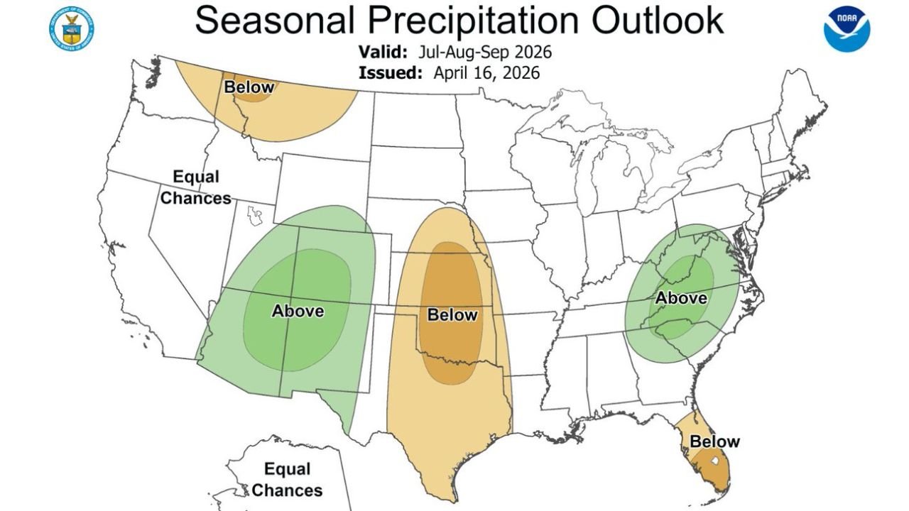
The NOAA Climate Prediction Center outlook, issued April 16, 2026 and valid for July through September 2026, identifies several distinct precipitation zones across the country driven largely by a warming Eastern Pacific and a possible rapid transition toward El Nino conditions — the oceanic warming pattern that historically enhances Southwest monsoon activity while suppressing rainfall across the southern Plains.
The Southwest Monsoon Signal
The most promising signal in this outlook for drought-stressed communities falls across the Southwest. The above-normal precipitation zone — shown in green — covers southwest Colorado, Utah, Arizona, and New Mexico, with the core of the highest above-normal probability centered over Arizona and the Four Corners region.
The North American Monsoon — the seasonal wind shift that draws moisture northward from the Gulf of California into the Desert Southwest each summer between roughly July and September — is the primary mechanism that would deliver this above-normal rainfall. When Eastern Pacific sea surface temperatures run warm and atmospheric conditions favor an El Nino transition, monsoon moisture typically penetrates further north and deeper into Colorado and Utah than in neutral or La Nina years.
Southwest Colorado is specifically highlighted as a region that would especially benefit from this pattern — a significant development for a state that has faced persistent drought conditions and elevated wildfire risk heading into the summer season. Above-normal monsoon rainfall across southwestern Colorado would provide meaningful drought relief, reduce wildfire fuel moisture deficits, and replenish reservoir levels that have been drawn down through the dry spring.
The Plains Dry Signal
The contrasting story sits directly to the east. A below-normal precipitation zone covers Kansas, Oklahoma, Missouri, and extends into Arkansas and Louisiana for the July through September period. The core of the driest below-normal signal — shown in the deepest orange — is centered over Oklahoma and Kansas, two states that have already been dealing with drought and above-normal wildfire potential through spring 2026.
A below-normal summer precipitation signal across Oklahoma and Kansas during the hottest months of the year compounds the drought risk significantly. Less monsoon-related moisture pushing northward from the Gulf of Mexico, combined with above-normal summer temperatures that are often associated with El Nino transitions, creates conditions that can rapidly intensify existing drought and push agricultural stress to critical levels across the southern Plains.
The Mid-Atlantic Above-Normal Signal
A separate above-normal precipitation zone appears across the mid-Atlantic corridor, covering Virginia, Maryland, Delaware, and surrounding states. This signal reflects a different large-scale driver than the Southwest monsoon enhancement and suggests a wetter-than-normal summer for communities along the Chesapeake Bay and Atlantic coast corridor.
Florida shows a below-normal signal, which is somewhat counterintuitive for a state that typically sees its heaviest rainfall during summer thunderstorm season — but is consistent with El Nino pattern tendencies that can suppress convection across the Florida Peninsula during summer months.
Seasonal Outlook Summary
| Signal | States | Implication |
|---|---|---|
| Above Normal | SW Colorado, Utah, Arizona, New Mexico | Active monsoon, drought relief potential |
| Above Normal | Virginia, Maryland, Delaware, Mid-Atlantic | Wetter than normal summer |
| Below Normal | Oklahoma, Kansas, Missouri, Arkansas | Dry summer, drought risk increases |
| Below Normal | Washington, Idaho fringe | Pacific Northwest summer dryness |
| Below Normal | Florida | Suppressed summer thunderstorm season |
| Equal Chances | California, Great Plains broadly, Midwest | No strong signal either direction |
Forecast Confidence
Confidence: Low to Moderate. Seasonal outlooks at the three-to-six month range carry significant inherent uncertainty. The Southwest above-normal monsoon signal and the Plains below-normal signal are both driven by the same large-scale oceanic pattern — a warming Eastern Pacific and possible El Nino development — which gives the outlook internal consistency and adds confidence to the directional signal. However, whether El Nino fully develops and how strongly it influences summer precipitation patterns will not be fully known until closer to the July through September window. The outlook represents the most probable outcome given current conditions, not a guaranteed forecast.
More seasonal precipitation outlook coverage is always on the horizon. Stay informed at ChicagoMusicGuide.com — your source for monsoon season and summer climate outlooks across Colorado, Oklahoma, the Southwest, and the entire United States.