Supercells Explode Along the Kansas-Oklahoma Border as the Cap Breaks and 45000-Foot Storms Erupt Near Enid and Blackwell in Minutes
ENID, OK — In one of the most dramatic storm initiation sequences of the spring season, the atmospheric cap along the Kansas-Oklahoma border shattered Thursday afternoon — and what followed happened with stunning speed. At 4:55 PM, there were no storms. By 5:20 PM, 45,000-foot supercells were exploding into the atmosphere near Enid, Oklahoma and the Blackwell corridor along the state line.
Twenty-five minutes. Clear sky to violent rotating storms reaching nearly nine miles into the atmosphere.
What Just Happened
The cap — the layer of warm air in the mid-levels of the atmosphere that had been suppressing storm development across Kansas and Oklahoma through the afternoon — gave way all at once along the Kansas-Oklahoma border. When a cap breaks in an environment this loaded with instability and wind shear, the result is not gradual storm development. It is explosive, near-instantaneous convection — storms that shoot from nothing to severe in minutes.
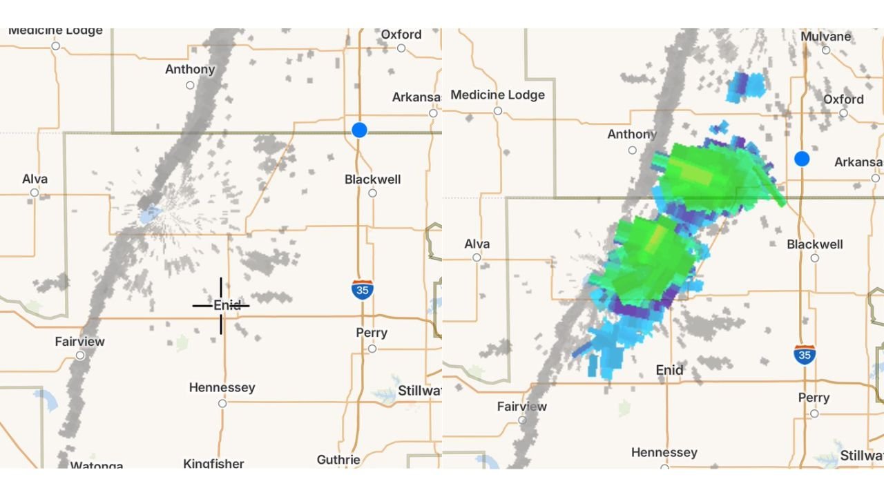
The radar sequence tells the story precisely. The first image, captured just before 5:00 PM, shows virtually no precipitation returns across the Enid, Anthony, Blackwell, and Alva corridor — gray noise and satellite clutter but no organized storm cells. The second image, captured approximately 25 minutes later, shows fully developed supercell storm cores in green, yellow, and blue tones stretching from near Anthony in southern Kansas southward through Blackwell and into the Enid corridor in northern Oklahoma.
The storm tops reaching 45,000 feet — nearly nine miles above the surface — are a direct measure of how violently the atmosphere responded when the cap finally broke. Storm tops at that altitude reflect updraft speeds that can only be sustained by an atmosphere that was under extreme suppression and released all at once. These are not ordinary thunderstorms. These are the rotating supercells that produce large hail, damaging winds, and tornadoes.
The Storm Development Timeline
| Time | Conditions |
|---|---|
| 4:55 PM | No storms — cap holding across Kansas-Oklahoma border |
| 5:20 PM | 45,000-foot supercells erupting — cap broken, supercells exploding |
| Active Zone | Anthony KS, Blackwell OK, Enid OK, Alva OK corridor |
| Storm Type | Supercells — rotating thunderstorms |
| Tops | 45,000 feet — extreme updraft intensity |
Where the Storms Are Right Now
Current radar shows the active supercell corridor extending along a north-south line from near Anthony, Kansas southward through Blackwell, Oklahoma and into the Enid area. The most intense radar returns — shown in yellow and green cores — are positioned along the Kansas-Oklahoma state line between Anthony and Blackwell, with a second organizing cluster near Enid to the south.
The storm motion is tracking generally eastward and southeastward, meaning communities east of the current storm position are in the path of these rapidly intensifying cells. Blackwell, Ponca City, Perry, Stillwater, and the broader north-central Oklahoma corridor are all downwind of the active supercell zone and should be on immediate weather alert status.
Who Needs to Act Right Now
Blackwell, Oklahoma Directly in the path of the most intense current radar returns along the Kansas-Oklahoma border. Blackwell residents should be sheltered immediately. Do not wait for a warning to be issued before moving to interior shelter on the lowest floor of a sturdy building.
Enid, Oklahoma The southern supercell cluster is positioned near Enid and moving east-southeast. Enid residents should treat this as an active tornado threat situation and be indoors with weather alerts active right now.
Anthony and Harper County, Kansas The northern extent of the active supercell line is near Anthony in Harper County, Kansas. Southern Kansas communities along and east of the storm line should be sheltered.
Ponca City, Perry and Stillwater These communities lie downwind of the current supercell position. As storms track eastward through the evening, Ponca City, Perry, and Stillwater will move into the active storm corridor. Monitor conditions continuously and be ready to shelter immediately upon warning issuance.
Forecast Confidence
Confidence: High — this is a live, active severe weather event. The supercells now erupting along the Kansas-Oklahoma border are real, radar-confirmed, and intensifying. The 25-minute window from clear skies to 45,000-foot storm tops reflects an atmosphere that was maximally loaded before the cap break — meaning these storms have access to extraordinary energy and wind shear as they continue to mature. All severe weather hazards including very large hail, damaging winds, and tornadoes are possible with these storms as they track east through north-central Oklahoma through the evening hours.
Seek shelter now if you are in the path of these storms. Do not attempt to observe or photograph from outside.
More live severe weather coverage is always on the horizon. Stay informed at ChicagoMusicGuide.com — your source for real-time supercell and tornado tracking across Kansas, Oklahoma, and the entire United States.