Large Tornadoes Possible Sunday From Texas to Iowa as a 10% Probability Zone Centers on Wichita and Kansas City
WICHITA, KS — The southern and central Plains are not getting a break. One day after a significant severe weather event hammered Oklahoma and northeast Texas, current tornado probability data issued Saturday afternoon is already pointing to another dangerous tornado day on Sunday, April 26, 2026 — and this time the bull’s-eye has shifted north, centering directly on Wichita, Kansas and the Kansas City metro corridor.
The next 72 hours across the central United States are shaping up to be one of the most active multi-day severe weather stretches of the spring season. Residents from north Texas all the way to Iowa need to be prepared before Sunday afternoon arrives.
What the Tornado Probability Data Shows
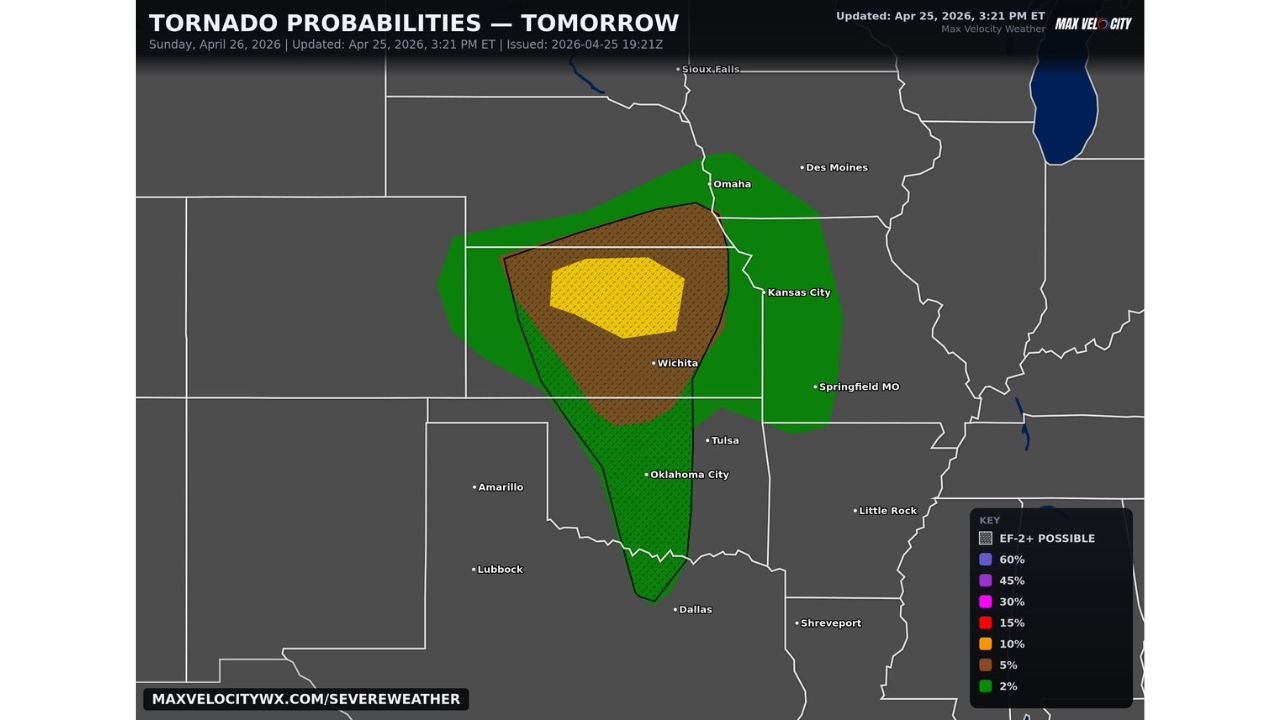
Tornado probability data issued at 3:21 PM ET on April 25, 2026, valid for Sunday, April 26, shows a layered threat zone that spans an enormous geographic footprint across the central Plains. The probability contours tell a clear story about where the greatest tornado danger is concentrated.
The innermost and highest-risk zone — shown in yellow on the probability map — carries a 10% tornado probability and is centered directly over south-central Kansas, encompassing the Wichita metro area and extending toward the Kansas City region to the northeast. A 10% tornado probability in a focused zone like this is a significant signal. It means that within any given 25-mile radius inside that zone, there is a 1-in-10 chance of a tornado touching down — and when atmospheric conditions support large, long-track tornadoes as they do in this setup, that number carries serious weight.
Surrounding that yellow core is a broader 5% probability zone shown in brown, which expands the risk corridor northward through eastern Kansas and into Nebraska, and southward through central Oklahoma toward the Dallas-Fort Worth area of Texas. The outermost 2% zone in green stretches the threat window from the Texas Panhandle and Oklahoma all the way to Omaha, Nebraska and the fringes of Iowa — a corridor spanning well over 600 miles from south to north.
Critically, the data also flags EF-2 or stronger tornadoes as possible across the higher-probability zones. An EF-2 on the Enhanced Fujita scale means winds of at least 111 mph — powerful enough to destroy mobile homes, snap large trees, and cause significant damage to well-built frame houses.
Why Large Tornadoes Are on the Table
The atmospheric setup driving Sunday’s threat is rooted in a persistent and aggressive storm pattern that has been fueling severe weather across the Plains for multiple consecutive days. A strong jet stream disturbance tracking across the central United States is providing the upper-level support needed for supercell development. At the surface, Gulf moisture continues to stream northward into Kansas and Nebraska, keeping dewpoints elevated and instability high.
The combination of strong directional wind shear — where winds change both speed and direction with altitude — and high atmospheric instability creates the rotating updraft environment that produces supercell thunderstorms. When supercells develop in a corridor like this on a day when low-level wind shear is this strong, large and violent tornadoes become a realistic outcome rather than a remote possibility.
Tornado Probability Breakdown Table
| Probability Zone | Coverage Area | Key Cities at Risk |
|---|---|---|
| 10% (Yellow Core) | South-central Kansas | Wichita, KS / Kansas City corridor |
| 5% (Brown) | Eastern Kansas, central Oklahoma, NE Texas | Tulsa OK, Oklahoma City OK, Dallas TX fringe |
| 2% (Green Outer) | Texas to Iowa broad corridor | Dallas TX, Amarillo TX, Omaha NE, Des Moines IA fringe |
| EF-2+ Flagged | Inside 5% and 10% zones | Wichita KS, Kansas City area, eastern Kansas |
State-by-State Threat Assessment
Kansas — Highest tornado risk on Sunday. The 10% probability core sits directly over the state. Wichita and surrounding communities in south-central Kansas face the greatest exposure to large, potentially violent tornadoes. The Kansas City metro on the northeast edge of the risk zone is also within range. Every resident in Kansas should have their warning plan locked in before noon Sunday.
Oklahoma — The 5% probability zone extends through central and eastern Oklahoma including the Oklahoma City and Tulsa corridors. After Saturday’s destructive tornado event near Enid, another round of tornado-warned storms is possible Sunday across the state.
Nebraska — The northern fringe of the 5% zone pushes into southern Nebraska. The Omaha area sits on the edge of the outer 2% contour. Tornado-warned storms are possible, particularly during the evening hours as the storm system tracks northeast.
Texas — The southern tail of the probability zone extends into north Texas, with the Dallas area and communities near the Oklahoma border sitting within the 2% to 5% range. Another severe weather day is in play for the northern tier of the state.
Iowa — The outer 2% zone clips the southern fringe of Iowa. While the tornado risk is lower here compared to Kansas, the threat is not zero. Severe thunderstorm and wind threats extend into the state as well.
Missouri — Springfield, Missouri sits near the eastern edge of the probability footprint. Tornado and severe storm chances increase if the storm track shifts slightly east of current model guidance.
Forecast Confidence
Confidence in a significant tornado day across south-central Kansas and adjacent areas on Sunday is MODERATE to HIGH. The tornado probability data is well-supported by current atmospheric analysis and the overall synoptic pattern. The primary uncertainty involves exact storm initiation timing and whether any morning convection could disrupt the environment — a factor that was also in play for Saturday’s event. Confidence in the EF-2 or stronger tornado potential within the 10% zone is MODERATE.
Do not wait for warnings to start preparing. Identify your shelter location now. Charge your devices. Know how you will receive warnings on Sunday — weather radio, smartphone alerts, and local broadcasts are all essential layers of your warning system.
More severe weather coverage is always on the horizon. Stay informed at ChicagoMusicGuide.com — your source for tornado tracking, multi-day outbreak coverage, and breaking severe weather alerts across the Plains and the entire United States.