Extreme Instability Builds Along a Sharp Texas and Oklahoma Boundary as Destructive Hail and Strong Tornadoes Expected Within Hours
DALLAS, TX — A razor-sharp atmospheric boundary is carving a line across north Texas and southern Oklahoma Saturday afternoon, and on one side of that line sits some of the most explosive storm fuel observed this entire spring season. Current analysis indicates surface-based instability values — the raw energy available to thunderstorms — are surging to between 4,000 and 5,000 joules per kilogram across the sunlit corridor of north-central Texas. That is an extraordinarily high number. For context, values above 2,500 joules per kilogram are considered very high. What is showing up on current data this afternoon is nearly double that threshold.
Storms are expected to fire within the next 1 to 3 hours from the time of this analysis, and when they do, they will have nearly unlimited fuel to work with.
The Differential Heating Boundary and Why It Matters
The atmospheric feature driving this setup is called a Differential Heating Boundary, or DHB. This is a surface boundary that forms when one part of the atmosphere receives intense direct solar heating while an adjacent area remains cooled and shaded under thick cloud cover. The result is a stark contrast — on the sunlit side, the air heats rapidly, moisture destabilizes, and instability explodes. On the cloudy side, the atmosphere remains capped and comparatively stable despite still being warm and moist.
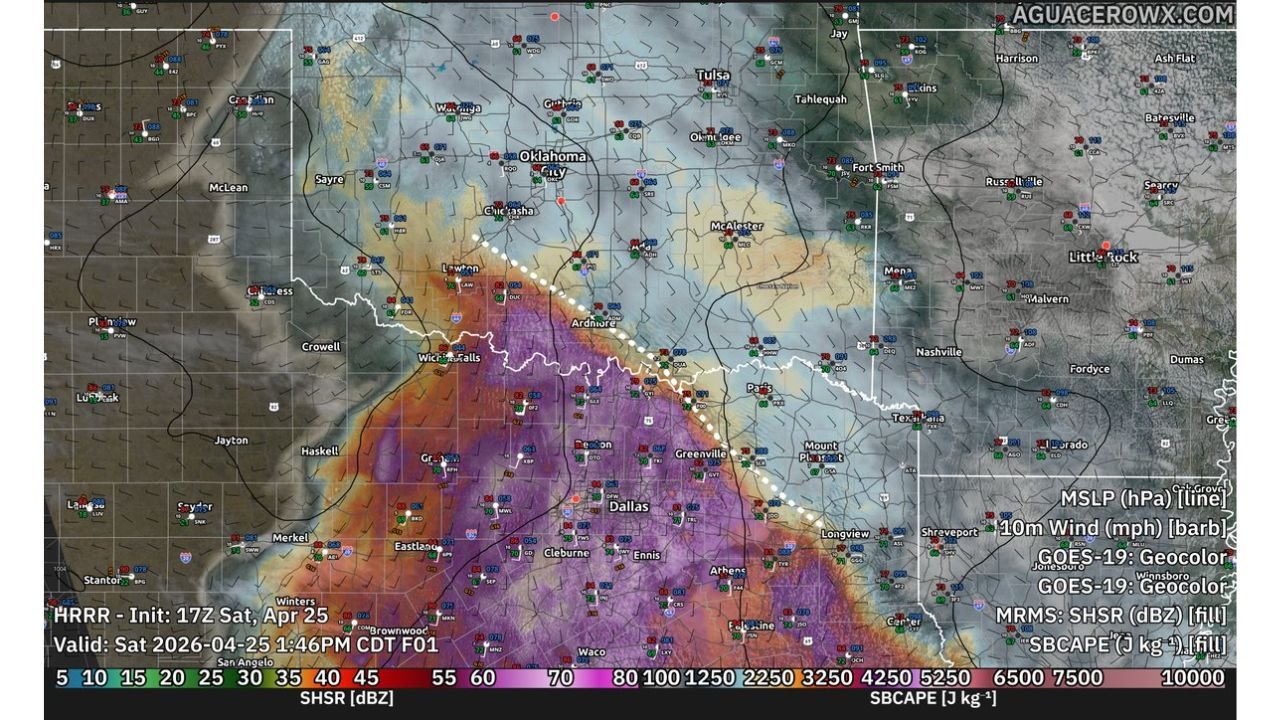
Current surface analysis shows this boundary draped across the region from north-central Texas through southern Oklahoma, oriented roughly from southwest to northeast. The dotted white line visible on current analysis maps traces this boundary precisely across communities including Ardmore, Paris, and Texarkana in the Texas-Oklahoma border region.
The critical forecasting concern is what happens when a developing supercell thunderstorm interacts directly with this boundary. Boundaries are known to dramatically enhance tornado potential by providing an additional source of low-level wind shear and spin at the surface. Any storm that tracks along or near this DHB will have substantially elevated tornado potential compared to storms that develop away from it.
The Numbers Behind the Threat
The instability data being observed right now across north Texas and the Red River Valley is striking. SBCAPE — which stands for Surface-Based Convective Available Potential Energy, the measure of explosive energy available to storms drawing from the lowest layers of the atmosphere — is reading between 4,000 and 5,000 J/kg across the core of the heated unstable plume south and west of Dallas. Values in the deep red and purple shading on current analysis maps extend across a broad swath of north-central and west Texas, indicating this is not a narrow ribbon of instability but a wide, deep reservoir of storm energy.
The northern tongue of this instability plume — where the heated, unstable air mass pushes farthest north into Oklahoma — is the focal point for initial storm development. This is where the atmosphere is most primed to explode in the coming hours.
Storm Initiation Timeline and Threat Window
Current analysis indicates storm initiation is expected within 1 to 3 hours of the early afternoon observation period, placing the first storm development during mid to late afternoon CDT on Saturday, April 25, 2026. Once storms fire along the DHB, they will have access to both the extreme instability values and the strong wind shear present in the environment — a combination that strongly favors organized supercell development.
The primary threats from afternoon and evening storms are identified as destructive hail and strong tornadoes. The tornado threat is specifically tied to storm interactions with the DHB itself. Storms that develop on or near the boundary will be able to tap into enhanced low-level rotation, increasing the probability of significant tornado development — including tornadoes rated EF-2 or higher on the Enhanced Fujita scale, meaning winds above 111 mph.
Instability and Threat Data Summary
| Parameter | Value / Status | Significance |
|---|---|---|
| SBCAPE (Peak) | 4,000 to 5,000 J/kg | Extremely high — nearly double severe threshold |
| Boundary Type | Differential Heating Boundary (DHB) | Major tornado enhancement feature |
| Boundary Location | North Texas through southern Oklahoma | Ardmore OK to Paris TX to Texarkana corridor |
| Storm Initiation | Within 1 to 3 hours of analysis | Mid to late afternoon CDT Saturday |
| Primary Threats | Destructive hail, strong tornadoes | EF-2+ tornado possible near boundary |
| Greatest Tornado Risk | Storms interacting with DHB directly | Boundary-hugging supercells most dangerous |
Area Threat Assessment
North-Central Texas — Highest instability values on the map. The Dallas-Fort Worth metro and surrounding communities including Wichita Falls, Greenville, and Corsicana are within the extreme instability plume. Afternoon supercell development is expected. Hail and tornado threats are both elevated.
Southern Oklahoma — The northern tongue of the instability plume pushes into southern Oklahoma through the Ardmore and McAlester corridors. The DHB intersects this area, making it the prime zone for boundary-enhanced tornado development. Oklahoma City sits on the northern fringe of the most elevated threat.
Red River Valley corridor (Texas-Oklahoma border) — This is the most critical zone to watch. The DHB is oriented along this corridor and any storm developing here will have maximum access to both instability and boundary-enhanced wind shear. Communities along U.S. Highway 82 and the Red River drainage are in the highest-risk area for strong tornadoes.
East Texas and ArkLaTex — The Texarkana area and eastern Texas communities sit downstream of the primary initiation zone. As storms mature and move east-northeast through the afternoon and evening, this corridor will see increasing severe weather impacts including hail and tornado-warned cells.
Tulsa and northeast Oklahoma — On the northern and eastern fringe of the instability plume. Storm activity is possible but the greatest instability is displaced to the south and west. Monitor for incoming severe cells from the southwest.
Forecast Confidence
Confidence in significant severe weather developing across north Texas and southern Oklahoma this afternoon and evening is HIGH. The instability values are observed, not just modeled — this energy is already in place. The DHB is clearly defined on current surface analysis. The primary remaining uncertainty is exact storm track and which specific communities fall in the path of the strongest cells. Confidence in the destructive hail threat is very high. Confidence in strong tornadoes is high, particularly for storms that develop along or interact with the DHB.
Afternoon severe weather in this setup can develop and intensify rapidly. A storm can go from initiation to tornado-warned in under 20 minutes in an environment this explosive. Do not wait for warnings to be issued before moving to your shelter.
More severe weather coverage is always on the horizon. Stay informed at ChicagoMusicGuide.com — your source for real-time severe storm analysis, tornado tracking, and breaking weather coverage across Texas, Oklahoma, and the entire United States.