Plains and Midwest Severe Weather Pattern Shows Signs of Returning for the Final Week of May 2026
OKLAHOMA CITY, OK — After a relatively quiet start to May, the atmosphere is showing early signals of a more active severe weather pattern developing as the month comes to a close. Current long-range model data is painting a concerning picture for the Plains and Midwest during the final week of May 2026, with the ingredients for organized severe weather beginning to come together.
What the Upper Level Pattern Is Showing
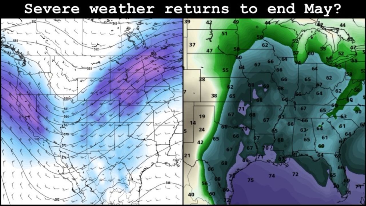
The left panel of current model analysis shows a deep upper-level trough digging into the western United States, with height values dropping into the 555 to 561 decameter range across the northern Plains and Midwest. This kind of upper-level pattern is the large-scale driver that sends severe weather outbreaks across Tornado Alley during late May. A strong trough to the west combined with a ridge to the east creates the jet stream configuration that channels storm systems directly into the central Plains.
Gulf Moisture Is Already Loading
The right panel shows surface dewpoints surging northward from the Gulf of Mexico, with values of 70 to 75 degrees Fahrenheit already present across southern Texas, Louisiana, and the Gulf Coast. Dewpoints of 66 to 70 degrees are shown pushing into Oklahoma, Kansas, and Missouri. This is the warm, moist airmass that fuels violent supercells and tornado outbreaks across the Plains in late May.
The combination of a deepening western trough and rich Gulf moisture streaming northward is precisely the setup that produces the most dangerous severe weather events of the spring season.
What This Means for Late May
| Factor | Current Signal | Severe Weather Implication |
|---|---|---|
| Upper level trough | Deep and digging westward | Strong jet stream forcing for Plains storms |
| Gulf dewpoints | 70 to 75°F at source | Exceptional fuel for supercell development |
| Midwest dewpoints | 66 to 70°F | Deep moisture well north into risk zone |
| Pattern timing | Final week of May | Peak climatological tornado season overlap |
Confidence and Timing
At this range confidence in specific event details remains LOW, but confidence in an active severe weather pattern returning to the Plains and Midwest for the final week of May is MODERATE and growing. Late May is climatologically the most dangerous tornado period of the entire year for Oklahoma, Kansas, Texas, and Nebraska. The pattern trend currently aligns with that climatological peak.
Residents across the central Plains and Midwest should begin monitoring the forecast closely heading into the May 25 through May 31 window.
More severe weather coverage is always on the horizon. Stay informed at ChicagoMusicGuide.com — your source for extended pattern analysis and breaking severe weather coverage across the Plains, Midwest, and the entire United States.